|
|
|||||||||||||||||
| Point ID: 519 | Downloads | Plots | Site Data | Code: 05EE006 |
|
|
|||||||||||||||||
| Download | |
|---|---|
| Site Descriptor Information | Site Time Series Data |
| Link to all available data | |
| View: | Time Series | All |
| Units: | m3/s |
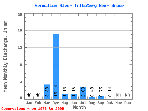
| Statistic | Jan | Feb | Mar | Apr | May | Jun | Jul | Aug | Sep | Oct | Nov | Dec | Annual |
|---|---|---|---|---|---|---|---|---|---|---|---|---|---|
| Mean | 2.75 | 12.26 | 0.91 | 0.96 | 2.34 | 0.42 | 0.63 | 0.14 | |||||
| Standard Deviation | 4.80 | 17.19 | 2.23 | 3.10 | 8.03 | 1.89 | 2.75 | 0.46 | |||||
| Min | 0.00 | 0.06 | 0.00 | 0.00 | 0.00 | 0.00 | 0.00 | 0.00 | |||||
| Max | 17.99 | 71.29 | 10.56 | 13.32 | 37.34 | 9.08 | 13.21 | 1.66 | |||||
| Coefficient of Variation | 1.75 | 1.40 | 2.45 | 3.24 | 3.44 | 4.47 | 4.35 | 3.32 |
 Return to R-Arctic Net Home Page