|
|
|||||||||||||||||
| Point ID: 5188 | Downloads | Plots | Site Data | Code: 04NA003 |
|
|
|||||||||||||||||
| Download | |
|---|---|
| Site Descriptor Information | Site Time Series Data |
| Link to all available data | |
|
|
| View: | Statistics | Time Series |
| Units: | mm |
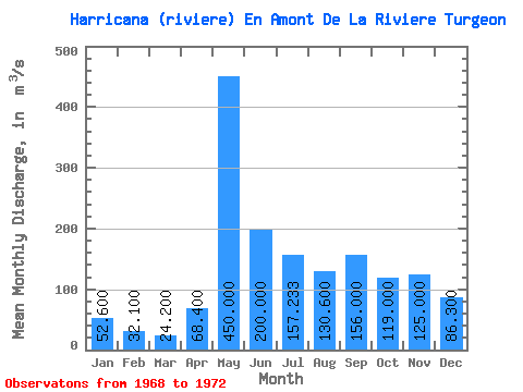
| Statistic | Jan | Feb | Mar | Apr | May | Jun | Jul | Aug | Sep | Oct | Nov | Dec | Annual |
|---|---|---|---|---|---|---|---|---|---|---|---|---|---|
| Mean | 52.60 | 32.10 | 24.20 | 68.40 | 450.00 | 200.00 | 157.23 | 130.60 | 156.00 | 119.00 | 125.00 | 86.30 | |
| Standard Deviation | 23.48 | 68.79 | 110.31 | 87.81 | 71.46 | 46.36 | |||||||
| Min | 52.60 | 32.10 | 24.20 | 50.20 | 372.00 | 122.00 | 91.70 | 85.60 | 104.00 | 119.00 | 125.00 | 86.30 | |
| Max | 52.60 | 32.10 | 24.20 | 94.90 | 502.00 | 278.00 | 257.00 | 213.00 | 193.00 | 119.00 | 125.00 | 86.30 | |
| Coefficient of Variation | 0.34 | 0.15 | 0.55 | 0.56 | 0.55 | 0.30 |
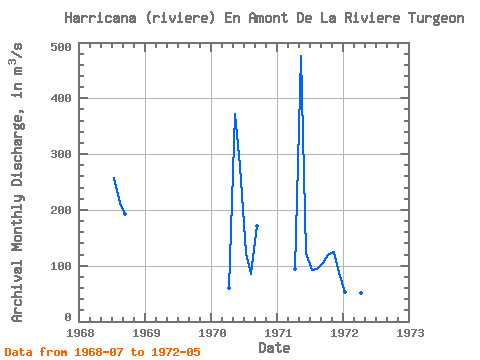
| Year | Jan | Feb | Mar | Apr | May | Jun | Jul | Aug | Sep | Oct | Nov | Dec | Annual | 1968 | 257.00 | 213.00 | 193.00 | 1970 | 60.10 | 372.00 | 278.00 | 123.00 | 85.60 | 171.00 | 1971 | 94.90 | 476.00 | 122.00 | 91.70 | 93.20 | 104.00 | 119.00 | 125.00 | 86.30 | 1972 | 52.60 | 32.10 | 24.20 | 50.20 | 502.00 |
|---|
 Return to R-Arctic Net Home Page