|
|
|||||||||||||||||
| Point ID: 5174 | Downloads | Plots | Site Data | Other Close Sites | Code: 03LA001 |
|
|
|||||||||||||||||
| Download | |
|---|---|
| Site Descriptor Information | Site Time Series Data |
| Link to all available data | |
|
|
| View: | Statistics | Time Series |
| Units: | mm |
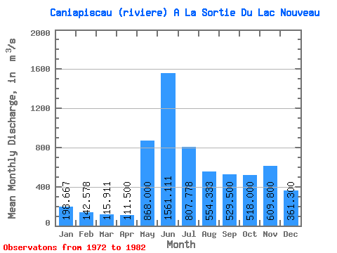
| Statistic | Jan | Feb | Mar | Apr | May | Jun | Jul | Aug | Sep | Oct | Nov | Dec | Annual |
|---|---|---|---|---|---|---|---|---|---|---|---|---|---|
| Mean | 198.67 | 142.58 | 115.91 | 111.50 | 868.00 | 1561.11 | 807.78 | 554.33 | 529.50 | 518.00 | 609.80 | 361.30 | 539.67 |
| Standard Deviation | 79.22 | 46.67 | 35.55 | 38.90 | 577.96 | 241.68 | 199.53 | 165.29 | 192.71 | 124.93 | 442.47 | 219.18 | 144.78 |
| Min | 132.00 | 95.20 | 75.90 | 71.80 | 222.00 | 1110.00 | 572.00 | 349.00 | 334.00 | 354.00 | 330.00 | 187.00 | 400.74 |
| Max | 349.00 | 209.00 | 185.00 | 182.00 | 2220.00 | 1980.00 | 1140.00 | 918.00 | 913.00 | 715.00 | 1800.00 | 875.00 | 845.67 |
| Coefficient of Variation | 0.40 | 0.33 | 0.31 | 0.35 | 0.67 | 0.15 | 0.25 | 0.30 | 0.36 | 0.24 | 0.73 | 0.61 | 0.27 |
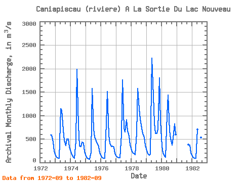
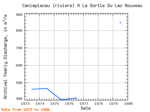
| Year | Jan | Feb | Mar | Apr | May | Jun | Jul | Aug | Sep | Oct | Nov | Dec | Annual | 1972 | 583.00 | 588.00 | 435.00 | 243.00 | 1973 | 149.00 | 108.00 | 90.40 | 86.20 | 1150.00 | 1110.00 | 697.00 | 463.00 | 364.00 | 496.00 | 496.00 | 329.00 | 461.55 | 1974 | 228.00 | 164.00 | 116.00 | 95.90 | 460.00 | 1980.00 | 785.00 | 349.00 | 340.00 | 439.00 | 410.00 | 232.00 | 466.57 | 1975 | 138.00 | 95.20 | 75.90 | 71.80 | 222.00 | 1570.00 | 701.00 | 538.00 | 452.00 | 401.00 | 342.00 | 202.00 | 400.74 | 1976 | 134.00 | 104.00 | 90.40 | 87.40 | 824.00 | 1510.00 | 572.00 | 408.00 | 334.00 | 354.00 | 330.00 | 187.00 | 411.23 | 1977 | 135.00 | 113.00 | 106.00 | 105.00 | 598.00 | 1760.00 | 731.00 | 646.00 | 913.00 | 669.00 | 563.00 | 374.00 | 559.42 | 1978 | 265.00 | 209.00 | 185.00 | 171.00 | 626.00 | 1570.00 | 1140.00 | 918.00 | 730.00 | 614.00 | 530.00 | 364.00 | 610.17 | 1979 | 258.00 | 193.00 | 153.00 | 182.00 | 2220.00 | 1680.00 | 839.00 | 616.00 | 617.00 | 715.00 | 1800.00 | 875.00 | 845.67 | 1980 | 349.00 | 194.00 | 135.00 | 115.00 | 1010.00 | 1440.00 | 675.00 | 514.00 | 371.00 | 518.00 | 823.00 | 600.00 | 562.00 | 1981 | 386.00 | 369.00 | 207.00 | 1982 | 132.00 | 103.00 | 91.50 | 89.20 | 702.00 | 1430.00 | 1130.00 | 537.00 | 591.00 |
|---|
| Other Close Sites | ||||||
|---|---|---|---|---|---|---|
| PointID | Latitude | Longitude | Drainage Area | Source | Name | |
| 5175 | "CANIAPISCAU (RIVIERE) EN AMONT DE LA DECHARGE DU LAC CHASTRIER" | 53.99 | -1406366 | Hydat | ||
 Return to R-Arctic Net Home Page