|
|
|||||||||||||||||
| Point ID: 5173 | Downloads | Plots | Site Data | Code: 03KE001 |
|
|
|||||||||||||||||
| Download | |
|---|---|
| Site Descriptor Information | Site Time Series Data |
| Link to all available data | |
|
|
| View: | Statistics | Time Series |
| Units: | mm |
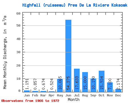
| Statistic | Jan | Feb | Mar | Apr | May | Jun | Jul | Aug | Sep | Oct | Nov | Dec | Annual |
|---|---|---|---|---|---|---|---|---|---|---|---|---|---|
| Mean | 1.19 | 0.86 | 0.67 | 0.52 | 10.06 | 54.38 | 17.63 | 15.00 | 10.19 | 15.93 | 7.10 | 2.17 | 13.35 |
| Standard Deviation | 0.37 | 0.43 | 0.46 | 0.35 | 10.99 | 24.82 | 2.82 | 7.92 | 5.55 | 6.30 | 2.79 | 0.67 | |
| Min | 0.71 | 0.19 | 0.07 | 0.05 | 1.13 | 22.80 | 15.40 | 9.40 | 4.39 | 8.67 | 3.59 | 1.41 | 13.35 |
| Max | 1.67 | 1.32 | 1.30 | 0.94 | 23.90 | 83.00 | 20.80 | 20.60 | 17.40 | 23.80 | 9.59 | 3.19 | 13.35 |
| Coefficient of Variation | 0.31 | 0.51 | 0.68 | 0.66 | 1.09 | 0.46 | 0.16 | 0.53 | 0.55 | 0.40 | 0.39 | 0.31 |
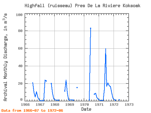
| Year | Jan | Feb | Mar | Apr | May | Jun | Jul | Aug | Sep | Oct | Nov | Dec | Annual | 1966 | 20.80 | 9.40 | 4.39 | 10.70 | 4.59 | 1.99 | 1967 | 0.71 | 0.19 | 0.07 | 0.05 | 23.90 | 22.80 | 20.00 | 8.68 | 2.42 | 1968 | 1.42 | 1.07 | 0.88 | 0.77 | 11.20 | 23.80 | 9.05 | 1.41 | 1969 | 1.06 | 1.32 | 1.30 | 0.94 | 15.40 | 1970 | 1.13 | 83.00 | 7.77 | 8.67 | 3.59 | 1.86 | 1971 | 1.09 | 0.69 | 0.48 | 0.40 | 13.90 | 59.60 | 16.70 | 20.60 | 17.40 | 16.50 | 9.59 | 3.19 | 13.35 | 1972 | 1.67 | 1.01 | 0.63 | 0.46 | 1.33 | 52.10 |
|---|
 Return to R-Arctic Net Home Page