|
|
|||||||||||||||||
| Point ID: 5172 | Downloads | Plots | Site Data | Other Close Sites | Code: 03KC004 |
|
|
|||||||||||||||||
| Download | |
|---|---|
| Site Descriptor Information | Site Time Series Data |
| Link to all available data | |
|
|
| View: | Statistics | Time Series |
| Units: | mm |
| Statistic | Jan | Feb | Mar | Apr | May | Jun | Jul | Aug | Sep | Oct | Nov | Dec | Annual |
|---|---|---|---|---|---|---|---|---|---|---|---|---|---|
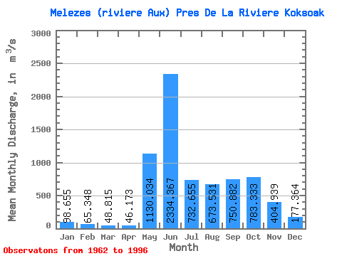
| Mean | 98.66 | 65.35 | 48.81 | 46.17 | 1130.03 | 2334.37 | 732.65 | 673.53 | 750.88 | 783.33 | 404.94 | 177.36 | 611.41 |
| Standard Deviation | 27.29 | 20.32 | 17.13 | 17.34 | 723.67 | 922.28 | 260.54 | 413.29 | 252.32 | 218.86 | 151.03 | 48.83 | 86.78 |
| Min | 60.10 | 33.70 | 25.00 | 23.20 | 44.10 | 645.00 | 246.00 | 219.00 | 330.00 | 305.00 | 199.00 | 112.00 | 338.08 |
| Max | 170.00 | 122.00 | 103.00 | 100.00 | 2400.00 | 4170.00 | 1190.00 | 2190.00 | 1510.00 | 1120.00 | 858.00 | 298.00 | 752.87 |
| Coefficient of Variation | 0.28 | 0.31 | 0.35 | 0.38 | 0.64 | 0.40 | 0.36 | 0.61 | 0.34 | 0.28 | 0.37 | 0.28 | 0.14 |
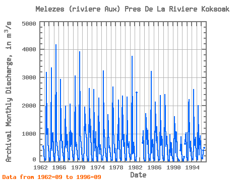
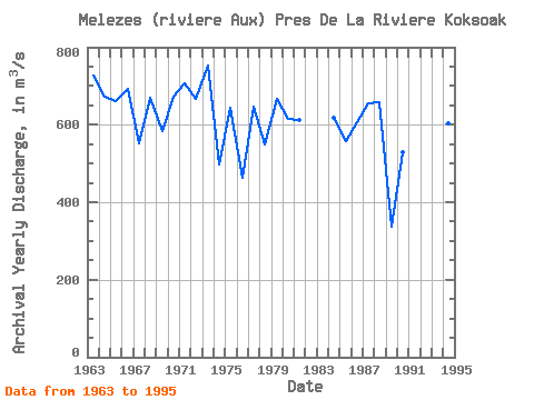
| Year | Jan | Feb | Mar | Apr | May | Jun | Jul | Aug | Sep | Oct | Nov | Dec | Annual | 1962 | 526.00 | 573.00 | 320.00 | 214.00 | 1963 | 128.00 | 67.70 | 38.70 | 54.40 | 762.00 | 3180.00 | 969.00 | 1010.00 | 1170.00 | 623.00 | 521.00 | 207.00 | 727.57 | 1964 | 80.50 | 43.20 | 31.20 | 38.20 | 864.00 | 3340.00 | 614.00 | 396.00 | 987.00 | 1030.00 | 407.00 | 222.00 | 671.09 | 1965 | 117.00 | 68.40 | 43.40 | 33.70 | 585.00 | 4170.00 | 768.00 | 643.00 | 557.00 | 528.00 | 256.00 | 148.00 | 659.79 | 1966 | 93.40 | 65.30 | 52.70 | 48.30 | 1440.00 | 2930.00 | 848.00 | 962.00 | 484.00 | 734.00 | 390.00 | 258.00 | 692.14 | 1967 | 127.00 | 68.30 | 41.90 | 30.90 | 1050.00 | 1980.00 | 493.00 | 520.00 | 647.00 | 950.00 | 501.00 | 200.00 | 550.76 | 1968 | 128.00 | 94.80 | 72.00 | 61.50 | 2050.00 | 1650.00 | 548.00 | 1040.00 | 615.00 | 1010.00 | 574.00 | 191.00 | 669.52 | 1969 | 119.00 | 102.00 | 78.00 | 50.70 | 493.00 | 3060.00 | 852.00 | 540.00 | 691.00 | 550.00 | 276.00 | 184.00 | 582.98 | 1970 | 132.00 | 97.50 | 71.70 | 54.50 | 120.00 | 3910.00 | 1110.00 | 722.00 | 683.00 | 665.00 | 334.00 | 157.00 | 671.39 | 1971 | 84.40 | 52.70 | 37.60 | 34.00 | 539.00 | 1950.00 | 1110.00 | 1690.00 | 994.00 | 981.00 | 734.00 | 266.00 | 706.06 | 1972 | 134.00 | 73.40 | 42.60 | 29.50 | 44.10 | 2600.00 | 1190.00 | 875.00 | 1510.00 | 1030.00 | 320.00 | 139.00 | 665.63 | 1973 | 79.30 | 51.50 | 37.40 | 31.20 | 2200.00 | 2580.00 | 926.00 | 384.00 | 559.00 | 1070.00 | 858.00 | 258.00 | 752.87 | 1974 | 104.00 | 55.60 | 35.40 | 29.80 | 993.00 | 2270.00 | 561.00 | 270.00 | 570.00 | 602.00 | 308.00 | 186.00 | 498.73 | 1975 | 116.00 | 77.40 | 54.50 | 42.20 | 388.00 | 3230.00 | 967.00 | 1130.00 | 592.00 | 556.00 | 377.00 | 201.00 | 644.26 | 1976 | 115.00 | 67.60 | 41.90 | 30.30 | 1680.00 | 1250.00 | 494.00 | 563.00 | 563.00 | 424.00 | 199.00 | 128.00 | 462.98 | 1977 | 87.60 | 63.10 | 48.20 | 41.20 | 1510.00 | 2660.00 | 1170.00 | 732.00 | 517.00 | 305.00 | 473.00 | 152.00 | 646.59 | 1978 | 60.10 | 33.70 | 25.00 | 23.20 | 895.00 | 1060.00 | 457.00 | 2190.00 | 905.00 | 577.00 | 252.00 | 114.00 | 549.33 | 1979 | 71.90 | 55.30 | 49.60 | 59.30 | 1520.00 | 2330.00 | 997.00 | 548.00 | 871.00 | 961.00 | 406.00 | 146.00 | 667.92 | 1980 | 78.90 | 55.80 | 46.70 | 44.10 | 1850.00 | 2310.00 | 644.00 | 507.00 | 567.00 | 706.00 | 363.00 | 192.00 | 613.71 | 1981 | 128.00 | 98.30 | 82.00 | 74.60 | 443.00 | 3750.00 | 913.00 | 280.00 | 330.00 | 685.00 | 407.00 | 157.00 | 612.33 | 1982 | 78.50 | 52.70 | 39.70 | 35.80 | 315.00 | 2470.00 | 1983 | 671.00 | 1100.00 | 402.00 | 122.00 | 1984 | 64.80 | 42.40 | 34.20 | 43.10 | 1720.00 | 1420.00 | 951.00 | 611.00 | 834.00 | 1120.00 | 408.00 | 161.00 | 617.46 | 1985 | 83.50 | 56.50 | 45.80 | 42.40 | 477.00 | 3210.00 | 366.00 | 315.00 | 723.00 | 794.00 | 462.00 | 131.00 | 558.85 | 1986 | 73.00 | 53.00 | 43.20 | 53.70 | 2120.00 | 1270.00 | 798.00 | 678.00 | 1240.00 | 543.00 | 282.00 | 112.00 | 605.49 | 1987 | 61.90 | 46.90 | 41.20 | 76.20 | 2040.00 | 2360.00 | 580.00 | 609.00 | 913.00 | 699.00 | 308.00 | 124.00 | 654.93 | 1988 | 69.70 | 52.50 | 46.70 | 52.90 | 2400.00 | 1600.00 | 555.00 | 906.00 | 839.00 | 904.00 | 322.00 | 157.00 | 658.73 | 1989 | 87.30 | 53.20 | 33.40 | 28.10 | 819.00 | 956.00 | 430.00 | 219.00 | 373.00 | 668.00 | 263.00 | 127.00 | 338.08 | 1990 | 69.40 | 41.90 | 28.10 | 25.20 | 1600.00 | 1110.00 | 509.00 | 316.00 | 1060.00 | 1040.00 | 359.00 | 202.00 | 530.05 | 1991 | 130.00 | 90.00 | 64.90 | 50.50 | 401.00 | 840.00 | 888.00 | 347.00 | 141.00 | 1992 | 69.90 | 43.40 | 32.30 | 28.70 | 165.00 | 637.00 | 940.00 | 1030.00 | 355.00 | 175.00 | 1993 | 102.00 | 67.80 | 50.50 | 44.20 | 2050.00 | 2210.00 | 583.00 | 364.00 | 617.00 | 721.00 | 259.00 | 137.00 | 600.46 | 1994 | 90.50 | 69.70 | 60.50 | 56.50 | 641.00 | 2570.00 | 598.00 | 574.00 | 751.00 | 869.00 | 731.00 | 246.00 | 604.77 | 1995 | 121.00 | 72.90 | 56.90 | 74.80 | 1990.00 | 645.00 | 246.00 | 422.00 | 766.00 | 914.00 | 589.00 | 298.00 | 516.30 | 1996 | 170.00 | 122.00 | 103.00 | 100.00 | 398.00 | 499.00 | 625.00 |
|---|
| Other Close Sites | ||||||
|---|---|---|---|---|---|---|
| PointID | Latitude | Longitude | Drainage Area | Source | Name | |
| 5171 | "MELEZES (RIVIERE AUX) PRES DE LA RIVIERE KOKSOAK-2" | 57.68 | -1236787 | Hydat | ||
 Return to R-Arctic Net Home Page