|
|
|||||||||||||||||
| Point ID: 5157 | Downloads | Plots | Site Data | Code: 03GC001 |
|
|
|||||||||||||||||
| Download | |
|---|---|
| Site Descriptor Information | Site Time Series Data |
| Link to all available data | |
|
|
| View: | Statistics | Time Series |
| Units: | mm |
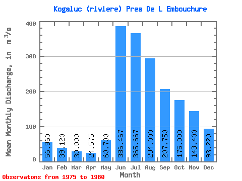
| Statistic | Jan | Feb | Mar | Apr | May | Jun | Jul | Aug | Sep | Oct | Nov | Dec | Annual |
|---|---|---|---|---|---|---|---|---|---|---|---|---|---|
| Mean | 56.96 | 39.12 | 30.00 | 24.57 | 60.70 | 386.47 | 365.67 | 294.00 | 207.75 | 175.00 | 143.40 | 93.22 | 159.96 |
| Standard Deviation | 11.32 | 6.15 | 4.35 | 2.35 | 40.57 | 368.58 | 151.86 | 113.41 | 87.52 | 69.94 | 30.98 | 23.77 | 73.42 |
| Min | 40.40 | 29.70 | 24.10 | 22.30 | 20.90 | 81.40 | 224.00 | 210.00 | 139.00 | 112.00 | 110.00 | 62.80 | 97.69 |
| Max | 66.10 | 44.50 | 35.30 | 27.50 | 102.00 | 796.00 | 526.00 | 423.00 | 326.00 | 289.00 | 185.00 | 120.00 | 240.92 |
| Coefficient of Variation | 0.20 | 0.16 | 0.14 | 0.10 | 0.67 | 0.95 | 0.41 | 0.39 | 0.42 | 0.40 | 0.22 | 0.26 | 0.46 |
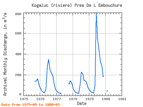
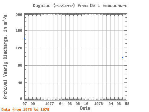
| Year | Jan | Feb | Mar | Apr | May | Jun | Jul | Aug | Sep | Oct | Nov | Dec | Annual | 1975 | 139.00 | 140.00 | 162.00 | 106.00 | 1976 | 66.10 | 44.50 | 33.10 | 27.50 | 59.20 | 282.00 | 347.00 | 249.00 | 222.00 | 192.00 | 110.00 | 62.80 | 141.27 | 1977 | 40.40 | 29.70 | 24.10 | 22.30 | 112.00 | 142.00 | 120.00 | 1978 | 65.40 | 40.70 | 28.50 | 23.10 | 20.90 | 81.40 | 224.00 | 210.00 | 144.00 | 142.00 | 118.00 | 74.30 | 97.69 | 1979 | 50.00 | 36.60 | 29.00 | 25.40 | 102.00 | 796.00 | 526.00 | 423.00 | 326.00 | 289.00 | 185.00 | 103.00 | 240.92 | 1980 | 62.90 | 44.10 | 35.30 |
|---|
 Return to R-Arctic Net Home Page