|
|
|||||||||||||||||
| Point ID: 5153 | Downloads | Plots | Site Data | Other Close Sites | Code: 03FC006 |
|
|
|||||||||||||||||
| Download | |
|---|---|
| Site Descriptor Information | Site Time Series Data |
| Link to all available data | |
|
|
| View: | Statistics | Time Series |
| Units: | mm |
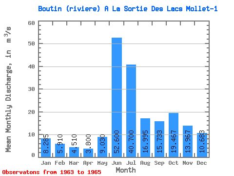
| Statistic | Jan | Feb | Mar | Apr | May | Jun | Jul | Aug | Sep | Oct | Nov | Dec | Annual |
|---|---|---|---|---|---|---|---|---|---|---|---|---|---|
| Mean | 8.29 | 5.91 | 4.51 | 3.80 | 9.03 | 52.60 | 40.70 | 17.00 | 15.73 | 19.47 | 13.97 | 10.68 | 17.09 |
| Standard Deviation | 0.05 | 0.81 | 0.99 | 0.88 | 7.31 | 8.63 | 16.41 | 12.59 | 5.02 | 4.76 | 3.77 | 1.92 | 1.96 |
| Min | 8.25 | 5.34 | 3.81 | 3.18 | 3.86 | 46.50 | 29.10 | 8.09 | 10.50 | 15.20 | 11.40 | 9.05 | 15.70 |
| Max | 8.32 | 6.48 | 5.21 | 4.42 | 14.20 | 58.70 | 52.30 | 25.90 | 20.50 | 24.60 | 18.30 | 12.80 | 18.48 |
| Coefficient of Variation | 0.01 | 0.14 | 0.22 | 0.23 | 0.81 | 0.16 | 0.40 | 0.74 | 0.32 | 0.24 | 0.27 | 0.18 | 0.12 |
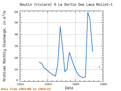
| Year | Jan | Feb | Mar | Apr | May | Jun | Jul | Aug | Sep | Oct | Nov | Dec | Annual | 1963 | 16.20 | 15.20 | 11.40 | 10.20 | 1964 | 8.25 | 6.48 | 5.21 | 4.42 | 14.20 | 46.50 | 29.10 | 8.09 | 10.50 | 24.60 | 18.30 | 12.80 | 15.70 | 1965 | 8.32 | 5.34 | 3.81 | 3.18 | 3.86 | 58.70 | 52.30 | 25.90 | 20.50 | 18.60 | 12.20 | 9.05 | 18.48 |
|---|
| Other Close Sites | ||||||
|---|---|---|---|---|---|---|
| PointID | Latitude | Longitude | Drainage Area | Source | Name | |
| 5151 | "BALEINE (PETITE RIVIERE DE LA)" | 55.73 | -991273 | Hydat | ||
| 5154 | "BOUTIN (RIVIERE) A LA SORTIE DES LAC MOLLET-2" | 55.57 | -1006550 | Hydat | ||
| 5155 | "BALEINE (PETITE RIVIERE DE LA) EN AMONT DU CHENAL ANCEL" | 55.68 | -1015440 | Hydat | ||
 Return to R-Arctic Net Home Page