|
|
|||||||||||||||||
| Point ID: 5144 | Downloads | Plots | Site Data | Code: 03FA003 |
|
|
|||||||||||||||||
| Download | |
|---|---|
| Site Descriptor Information | Site Time Series Data |
| Link to all available data | |
|
|
| View: | Statistics | Time Series |
| Units: | mm |
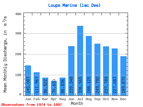
| Statistic | Jan | Feb | Mar | Apr | May | Jun | Jul | Aug | Sep | Oct | Nov | Dec | Annual |
|---|---|---|---|---|---|---|---|---|---|---|---|---|---|
| Mean | 145.09 | 111.97 | 86.52 | 70.63 | 86.84 | 239.35 | 336.56 | 288.12 | 249.79 | 237.78 | 227.09 | 189.87 | 192.58 |
| Standard Deviation | 23.61 | 16.34 | 11.73 | 9.66 | 23.48 | 75.00 | 99.18 | 68.69 | 62.25 | 63.34 | 60.00 | 40.31 | 23.19 |
| Min | 108.00 | 84.60 | 68.00 | 57.80 | 58.30 | 101.00 | 129.00 | 171.00 | 145.00 | 139.00 | 145.00 | 133.00 | 139.91 |
| Max | 206.00 | 155.00 | 119.00 | 95.40 | 138.00 | 431.00 | 551.00 | 485.00 | 364.00 | 403.00 | 369.00 | 282.00 | 237.70 |
| Coefficient of Variation | 0.16 | 0.15 | 0.14 | 0.14 | 0.27 | 0.31 | 0.29 | 0.24 | 0.25 | 0.27 | 0.26 | 0.21 | 0.12 |
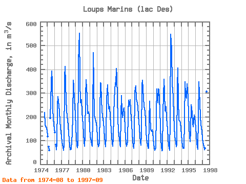
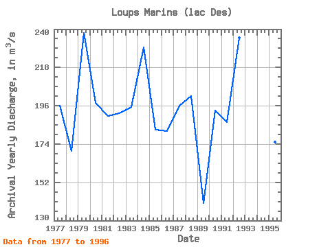
| Year | Jan | Feb | Mar | Apr | May | Jun | Jul | Aug | Sep | Oct | Nov | Dec | Annual | 1974 | 219.00 | 167.00 | 159.00 | 157.00 | 142.00 | 1975 | 118.00 | 74.60 | 58.60 | 195.00 | 341.00 | 393.00 | 346.00 | 231.00 | 192.00 | 167.00 | 1976 | 135.00 | 83.00 | 62.30 | 89.80 | 248.00 | 286.00 | 246.00 | 221.00 | 181.00 | 151.00 | 135.00 | 1977 | 117.00 | 93.30 | 72.60 | 59.10 | 81.60 | 366.00 | 412.00 | 340.00 | 266.00 | 198.00 | 187.00 | 162.00 | 196.22 | 1978 | 131.00 | 105.00 | 79.30 | 62.00 | 63.40 | 101.00 | 129.00 | 203.00 | 353.00 | 331.00 | 270.00 | 214.00 | 170.14 | 1979 | 153.00 | 111.00 | 81.50 | 68.90 | 85.00 | 431.00 | 551.00 | 351.00 | 259.00 | 270.00 | 273.00 | 218.00 | 237.70 | 1980 | 167.00 | 127.00 | 94.30 | 76.90 | 121.00 | 290.00 | 356.00 | 284.00 | 215.00 | 214.00 | 220.00 | 204.00 | 197.43 | 1981 | 151.00 | 118.00 | 98.10 | 82.40 | 76.40 | 198.00 | 470.00 | 341.00 | 207.00 | 188.00 | 179.00 | 174.00 | 190.24 | 1982 | 154.00 | 115.00 | 89.60 | 74.70 | 90.20 | 221.00 | 343.00 | 338.00 | 270.00 | 226.00 | 202.00 | 177.00 | 191.71 | 1983 | 143.00 | 114.00 | 90.50 | 74.30 | 117.00 | 277.00 | 334.00 | 272.00 | 233.00 | 244.00 | 243.00 | 200.00 | 195.15 | 1984 | 149.00 | 113.00 | 90.80 | 76.60 | 110.00 | 207.00 | 277.00 | 343.00 | 335.00 | 403.00 | 369.00 | 279.00 | 229.37 | 1985 | 193.00 | 144.00 | 107.00 | 84.30 | 74.80 | 205.00 | 290.00 | 222.00 | 197.00 | 228.00 | 238.00 | 206.00 | 182.43 | 1986 | 151.00 | 114.00 | 90.60 | 75.50 | 93.10 | 220.00 | 269.00 | 244.00 | 254.00 | 272.00 | 225.00 | 168.00 | 181.35 | 1987 | 127.00 | 98.70 | 79.50 | 67.30 | 105.00 | 304.00 | 330.00 | 274.00 | 266.00 | 257.00 | 242.00 | 204.00 | 196.21 | 1988 | 151.00 | 117.00 | 94.90 | 80.50 | 127.00 | 333.00 | 353.00 | 277.00 | 247.00 | 231.00 | 223.00 | 184.00 | 201.53 | 1989 | 138.00 | 107.00 | 82.60 | 68.20 | 68.10 | 187.00 | 265.00 | 201.00 | 145.00 | 139.00 | 145.00 | 133.00 | 139.91 | 1990 | 108.00 | 84.60 | 68.00 | 58.50 | 68.30 | 215.00 | 317.00 | 278.00 | 260.00 | 318.00 | 314.00 | 231.00 | 193.37 | 1991 | 154.00 | 105.00 | 74.40 | 57.80 | 59.70 | 219.00 | 359.00 | 302.00 | 225.00 | 245.00 | 243.00 | 194.00 | 186.49 | 1992 | 147.00 | 105.00 | 83.10 | 67.40 | 58.30 | 191.00 | 548.00 | 485.00 | 331.00 | 320.00 | 277.00 | 209.00 | 235.15 | 1993 | 155.00 | 117.00 | 91.20 | 74.20 | 84.20 | 325.00 | 405.00 | 272.00 | 187.00 | 182.00 | 173.00 | 151.00 | 184.72 | 1994 | 123.00 | 97.10 | 79.50 | 67.50 | 67.90 | 187.00 | 347.00 | 293.00 | 286.00 | 278.00 | 338.00 | 282.00 | 203.83 | 1995 | 206.00 | 155.00 | 119.00 | 95.40 | 138.00 | 250.00 | 217.00 | 171.00 | 159.00 | 186.00 | 208.00 | 196.00 | 175.03 | 1996 | 155.00 | 119.00 | 91.30 | 71.60 | 63.20 | 196.00 | 348.00 | 259.00 | 202.00 | 168.00 | 154.00 | 137.00 | 163.68 | 1997 | 111.00 | 91.60 | 74.60 | 60.50 | 68.40 | 139.00 | 194.00 | 307.00 | 364.00 |
|---|
 Return to R-Arctic Net Home Page