|
|
|||||||||||||||||
| Point ID: 5131 | Downloads | Plots | Site Data | Code: 03DF001 |
|
|
|||||||||||||||||
| Download | |
|---|---|
| Site Descriptor Information | Site Time Series Data |
| Link to all available data | |
| View: | Time Series | All |
| Units: | m3/s |
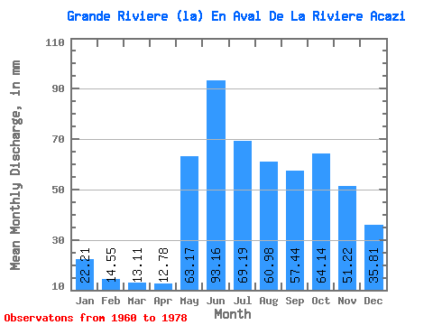
| Statistic | Jan | Feb | Mar | Apr | May | Jun | Jul | Aug | Sep | Oct | Nov | Dec | Annual |
|---|---|---|---|---|---|---|---|---|---|---|---|---|---|
| Mean | 22.21 | 14.67 | 13.11 | 12.78 | 63.16 | 93.17 | 69.17 | 60.98 | 57.44 | 64.13 | 51.22 | 35.80 | 552.23 |
| Standard Deviation | 4.83 | 2.97 | 2.22 | 2.13 | 20.90 | 20.24 | 19.21 | 20.48 | 17.50 | 18.77 | 11.81 | 8.51 | 81.84 |
| Min | 15.33 | 9.67 | 9.56 | 9.53 | 31.60 | 48.03 | 48.79 | 31.33 | 29.78 | 34.10 | 26.83 | 19.96 | 410.21 |
| Max | 32.99 | 22.03 | 19.13 | 17.15 | 116.71 | 124.50 | 118.38 | 97.03 | 89.08 | 100.63 | 74.06 | 56.28 | 695.18 |
| Coefficient of Variation | 0.22 | 0.20 | 0.17 | 0.17 | 0.33 | 0.22 | 0.28 | 0.34 | 0.30 | 0.29 | 0.23 | 0.24 | 0.15 |
 Return to R-Arctic Net Home Page