|
|
|||||||||||||||||
| Point ID: 5126 | Downloads | Plots | Site Data | Other Close Sites | Code: 03DE001 |
|
|
|||||||||||||||||
| Download | |
|---|---|
| Site Descriptor Information | Site Time Series Data |
| Link to all available data | |
|
|
| View: | Statistics | Time Series |
| Units: | mm |
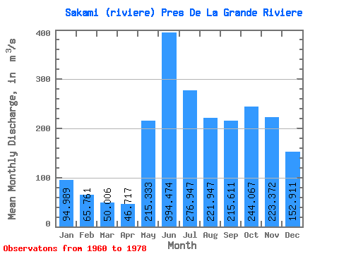
| Statistic | Jan | Feb | Mar | Apr | May | Jun | Jul | Aug | Sep | Oct | Nov | Dec | Annual |
|---|---|---|---|---|---|---|---|---|---|---|---|---|---|
| Mean | 94.99 | 65.76 | 50.01 | 46.72 | 215.33 | 394.47 | 276.95 | 221.95 | 215.61 | 244.07 | 223.37 | 152.91 | 183.37 |
| Standard Deviation | 23.64 | 13.26 | 7.82 | 7.14 | 81.14 | 109.20 | 90.50 | 79.20 | 86.41 | 96.49 | 69.54 | 38.63 | 33.06 |
| Min | 49.90 | 41.80 | 35.90 | 34.20 | 125.00 | 195.00 | 193.00 | 118.00 | 87.60 | 83.20 | 84.70 | 64.60 | 134.18 |
| Max | 155.00 | 97.10 | 66.60 | 58.60 | 414.00 | 685.00 | 524.00 | 348.00 | 372.00 | 403.00 | 340.00 | 240.00 | 242.64 |
| Coefficient of Variation | 0.25 | 0.20 | 0.16 | 0.15 | 0.38 | 0.28 | 0.33 | 0.36 | 0.40 | 0.40 | 0.31 | 0.25 | 0.18 |
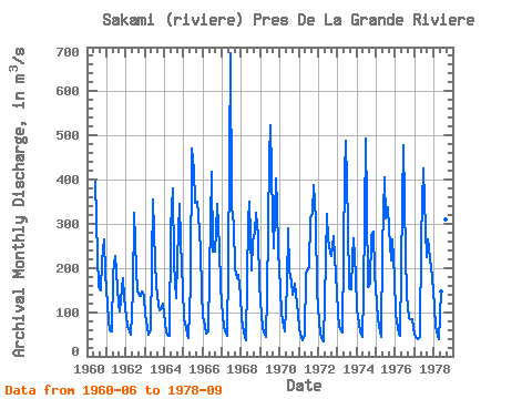
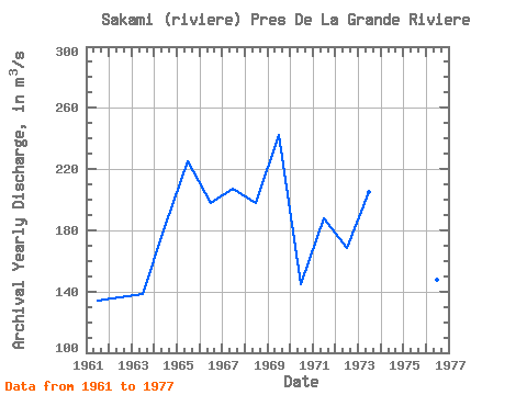
| Year | Jan | Feb | Mar | Apr | May | Jun | Jul | Aug | Sep | Oct | Nov | Dec | Annual | 1960 | 395.00 | 227.00 | 156.00 | 149.00 | 216.00 | 265.00 | 187.00 | 1961 | 120.00 | 80.80 | 59.50 | 56.90 | 187.00 | 228.00 | 193.00 | 118.00 | 101.00 | 155.00 | 178.00 | 133.00 | 134.18 | 1962 | 90.00 | 68.10 | 56.70 | 48.20 | 146.00 | 324.00 | 197.00 | 149.00 | 137.00 | 136.00 | 148.00 | 136.00 | 136.33 | 1963 | 94.00 | 64.70 | 47.90 | 58.60 | 212.00 | 355.00 | 212.00 | 161.00 | 116.00 | 105.00 | 111.00 | 120.00 | 138.10 | 1964 | 77.20 | 54.90 | 46.00 | 47.00 | 290.00 | 379.00 | 210.00 | 132.00 | 219.00 | 346.00 | 259.00 | 151.00 | 184.26 | 1965 | 86.40 | 64.30 | 48.70 | 40.40 | 164.00 | 471.00 | 422.00 | 348.00 | 351.00 | 321.00 | 243.00 | 143.00 | 225.23 | 1966 | 91.90 | 68.10 | 51.20 | 55.50 | 189.00 | 418.00 | 237.00 | 236.00 | 282.00 | 346.00 | 247.00 | 156.00 | 198.14 | 1967 | 91.20 | 66.50 | 52.50 | 46.10 | 208.00 | 685.00 | 340.00 | 297.00 | 198.00 | 176.00 | 185.00 | 140.00 | 207.11 | 1968 | 83.80 | 55.30 | 42.20 | 36.20 | 307.00 | 351.00 | 194.00 | 263.00 | 281.00 | 325.00 | 272.00 | 161.00 | 197.62 | 1969 | 93.90 | 67.40 | 53.00 | 44.40 | 139.00 | 447.00 | 524.00 | 315.00 | 245.00 | 403.00 | 340.00 | 240.00 | 242.64 | 1970 | 155.00 | 97.10 | 66.60 | 56.20 | 163.00 | 291.00 | 194.00 | 170.00 | 140.00 | 164.00 | 142.00 | 96.80 | 144.64 | 1971 | 62.10 | 45.00 | 35.90 | 45.80 | 186.00 | 195.00 | 201.00 | 315.00 | 323.00 | 387.00 | 307.00 | 149.00 | 187.65 | 1972 | 77.30 | 53.60 | 40.30 | 34.20 | 125.00 | 322.00 | 265.00 | 235.00 | 227.00 | 271.00 | 225.00 | 146.00 | 168.45 | 1973 | 96.70 | 68.70 | 57.00 | 53.40 | 414.00 | 488.00 | 300.00 | 154.00 | 152.00 | 223.00 | 267.00 | 183.00 | 204.73 | 1974 | 107.00 | 72.90 | 52.80 | 44.50 | 139.00 | 493.00 | 346.00 | 156.00 | 164.00 | 273.00 | 282.00 | 188.00 | 193.18 | 1975 | 122.00 | 83.50 | 55.40 | 43.70 | 245.00 | 404.00 | 313.00 | 337.00 | 288.00 | 218.00 | 265.00 | 179.00 | 212.80 | 1976 | 96.40 | 63.50 | 50.10 | 47.60 | 348.00 | 478.00 | 229.00 | 139.00 | 87.60 | 83.20 | 84.70 | 64.60 | 147.64 | 1977 | 49.90 | 41.80 | 38.40 | 43.90 | 268.00 | 426.00 | 353.00 | 225.00 | 264.00 | 245.00 | 200.00 | 179.00 | 194.50 | 1978 | 115.00 | 67.50 | 45.90 | 38.30 | 146.00 | 345.00 | 305.00 | 311.00 | 372.00 |
|---|
| Other Close Sites | ||||||
|---|---|---|---|---|---|---|
| PointID | Latitude | Longitude | Drainage Area | Source | Name | |
| 5113 | "KANAAUPSCOW (RIVIERE) EN AMONT DU RUISSEAU POUTRE" | 53.75 | -893069 | Hydat | ||
| 5114 | "KANAAUPSCOW (RIVIERE) EN AMONT DU RUISSEAU POUTRE-2" | 53.75 | -893743 | Hydat | ||
| 5116 | "GRANDE RIVIERE (LA) EN AVAL DE LA RIVIERE SAKAMI" | 53.68 | -907562 | Hydat | ||
 Return to R-Arctic Net Home Page