|
|
|||||||||||||||||
| Point ID: 5105 | Downloads | Plots | Site Data | Code: 03CB004 |
|
|
|||||||||||||||||
| Download | |
|---|---|
| Site Descriptor Information | Site Time Series Data |
| Link to all available data | |
|
|
| View: | Statistics | Time Series |
| Units: | mm |
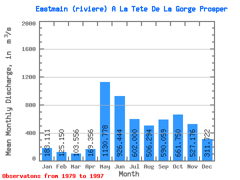
| Statistic | Jan | Feb | Mar | Apr | May | Jun | Jul | Aug | Sep | Oct | Nov | Dec | Annual |
|---|---|---|---|---|---|---|---|---|---|---|---|---|---|
| Mean | 183.11 | 125.15 | 103.56 | 169.36 | 1130.78 | 926.44 | 602.00 | 506.29 | 590.06 | 661.75 | 527.18 | 311.72 | 491.41 |
| Standard Deviation | 33.53 | 19.95 | 32.07 | 124.75 | 209.01 | 233.59 | 212.68 | 161.21 | 193.67 | 127.61 | 140.46 | 75.32 | 51.61 |
| Min | 125.00 | 80.70 | 57.20 | 71.50 | 751.00 | 559.00 | 287.00 | 205.00 | 275.00 | 394.00 | 365.00 | 212.00 | 399.09 |
| Max | 235.00 | 155.00 | 213.00 | 589.00 | 1590.00 | 1520.00 | 1240.00 | 720.00 | 1020.00 | 934.00 | 916.00 | 440.00 | 576.67 |
| Coefficient of Variation | 0.18 | 0.16 | 0.31 | 0.74 | 0.18 | 0.25 | 0.35 | 0.32 | 0.33 | 0.19 | 0.27 | 0.24 | 0.10 |
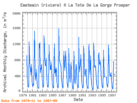
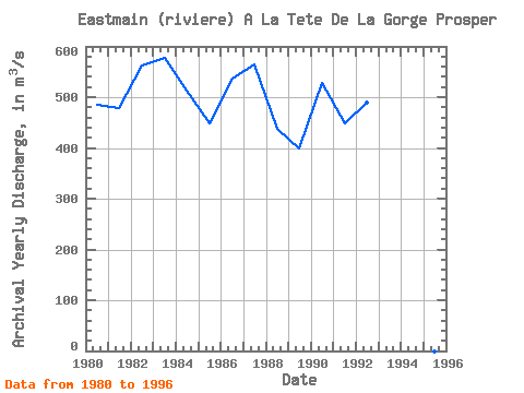
| Year | Jan | Feb | Mar | Apr | May | Jun | Jul | Aug | Sep | Oct | Nov | Dec | Annual | 1979 | 916.00 | 395.00 | 1980 | 225.00 | 155.00 | 120.00 | 151.00 | 1260.00 | 796.00 | 634.00 | 579.00 | 432.00 | 685.00 | 499.00 | 280.00 | 484.67 | 1981 | 161.00 | 132.00 | 213.00 | 173.00 | 1090.00 | 1520.00 | 550.00 | 301.00 | 420.00 | 565.00 | 379.00 | 236.00 | 478.33 | 1982 | 149.00 | 106.00 | 88.10 | 95.80 | 1210.00 | 1100.00 | 1240.00 | 478.00 | 590.00 | 577.00 | 693.00 | 424.00 | 562.58 | 1983 | 235.00 | 152.00 | 112.00 | 162.00 | 1410.00 | 1150.00 | 805.00 | 662.00 | 655.00 | 843.00 | 492.00 | 242.00 | 576.67 | 1984 | 163.00 | 131.00 | 120.00 | 217.00 | 1180.00 | 834.00 | 762.00 | 555.00 | 563.00 | 743.00 | 525.00 | 373.00 | 513.83 | 1985 | 205.00 | 133.00 | 104.00 | 105.00 | 775.00 | 1210.00 | 474.00 | 565.00 | 390.00 | 608.00 | 531.00 | 289.00 | 449.08 | 1986 | 172.00 | 120.00 | 102.00 | 208.00 | 1590.00 | 832.00 | 773.00 | 720.00 | 687.00 | 616.00 | 373.00 | 238.00 | 535.92 | 1987 | 158.00 | 114.00 | 93.30 | 589.00 | 1020.00 | 752.00 | 543.00 | 715.00 | 1020.00 | 783.00 | 545.00 | 440.00 | 564.36 | 1988 | 231.00 | 145.00 | 107.00 | 322.00 | 1090.00 | 559.00 | 379.00 | 243.00 | 526.00 | 741.00 | 547.00 | 358.00 | 437.33 | 1989 | 194.00 | 117.00 | 78.60 | 71.50 | 1020.00 | 797.00 | 287.00 | 205.00 | 275.00 | 653.00 | 692.00 | 399.00 | 399.09 | 1990 | 220.00 | 137.00 | 96.50 | 136.00 | 1370.00 | 805.00 | 506.00 | 616.00 | 702.00 | 934.00 | 540.00 | 280.00 | 528.54 | 1991 | 175.00 | 126.00 | 99.90 | 133.00 | 1150.00 | 905.00 | 512.00 | 388.00 | 501.00 | 571.00 | 568.00 | 245.00 | 447.82 | 1992 | 150.00 | 109.00 | 87.90 | 87.00 | 1070.00 | 1200.00 | 560.00 | 440.00 | 904.00 | 674.00 | 372.00 | 212.00 | 488.82 | 1993 | 125.00 | 80.70 | 57.20 | 76.80 | 1230.00 | 974.00 | 647.00 | 614.00 | 665.00 | 601.00 | 365.00 | 223.00 | 471.56 | 1994 | 144.00 | 103.00 | 84.80 | 88.90 | 908.00 | 986.00 | 715.00 | 683.00 | 783.00 | 600.00 | 443.00 | 266.00 | 483.73 | 1995 | 180.00 | 134.00 | 105.00 | 101.00 | 1050.00 | 693.00 | 383.00 | 365.00 | 1996 | 222.00 | 152.00 | 120.00 | 246.00 | 1180.00 | 835.00 | 502.00 | 405.00 | 398.00 | 394.00 | 482.00 | 346.00 | 440.17 | 1997 | 187.00 | 106.00 | 74.70 | 85.40 | 751.00 | 728.00 | 564.00 | 438.00 | 520.00 |
|---|
 Return to R-Arctic Net Home Page