|
|
|||||||||||||||||
| Point ID: 5095 | Downloads | Plots | Site Data | Code: 03BC001 |
|
|
|||||||||||||||||
| Download | |
|---|---|
| Site Descriptor Information | Site Time Series Data |
| Link to all available data | |
|
|
| View: | Statistics | Time Series |
| Units: | mm |
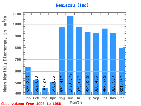
| Statistic | Jan | Feb | Mar | Apr | May | Jun | Jul | Aug | Sep | Oct | Nov | Dec | Annual |
|---|---|---|---|---|---|---|---|---|---|---|---|---|---|
| Mean | 635.27 | 527.82 | 459.09 | 508.64 | 974.42 | 1070.08 | 979.08 | 934.00 | 926.46 | 963.75 | 928.50 | 801.18 | 836.14 |
| Standard Deviation | 105.47 | 94.65 | 80.88 | 157.79 | 163.83 | 195.27 | 231.60 | 244.66 | 237.62 | 233.91 | 167.14 | 120.07 | 120.54 |
| Min | 447.00 | 366.00 | 333.00 | 350.00 | 671.00 | 736.00 | 687.00 | 625.00 | 581.00 | 676.00 | 741.00 | 634.00 | 655.92 |
| Max | 769.00 | 674.00 | 590.00 | 895.00 | 1280.00 | 1470.00 | 1450.00 | 1370.00 | 1280.00 | 1330.00 | 1270.00 | 953.00 | 965.08 |
| Coefficient of Variation | 0.17 | 0.18 | 0.18 | 0.31 | 0.17 | 0.18 | 0.24 | 0.26 | 0.26 | 0.24 | 0.18 | 0.15 | 0.14 |
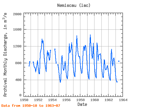
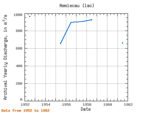
| Year | Jan | Feb | Mar | Apr | May | Jun | Jul | Aug | Sep | Oct | Nov | Dec | Annual | 1950 | 724.00 | 828.00 | 1951 | 822.00 | 736.00 | 690.00 | 687.00 | 581.00 | 676.00 | 741.00 | 859.00 | 1952 | 714.00 | 606.00 | 543.00 | 541.00 | 1030.00 | 1090.00 | 1160.00 | 1370.00 | 1280.00 | 1330.00 | 1050.00 | 867.00 | 965.08 | 1953 | 769.00 | 674.00 | 590.00 | 895.00 | 1090.00 | 978.00 | 1050.00 | 866.00 | 876.00 | 1100.00 | 1954 | 1130.00 | 952.00 | 802.00 | 754.00 | 669.00 | 1955 | 535.00 | 427.00 | 333.00 | 413.00 | 898.00 | 979.00 | 791.00 | 625.00 | 625.00 | 710.00 | 844.00 | 691.00 | 655.92 | 1956 | 526.00 | 447.00 | 421.00 | 667.00 | 955.00 | 1260.00 | 1040.00 | 1070.00 | 1130.00 | 1290.00 | 1080.00 | 904.00 | 899.17 | 1957 | 724.00 | 585.00 | 491.00 | 468.00 | 943.00 | 1110.00 | 1450.00 | 1200.00 | 1040.00 | 964.00 | 945.00 | 953.00 | 906.08 | 1958 | 745.00 | 631.00 | 545.00 | 574.00 | 923.00 | 1140.00 | 1200.00 | 1090.00 | 1220.00 | 1210.00 | 1050.00 | 794.00 | 926.83 | 1959 | 600.00 | 498.00 | 447.00 | 411.00 | 1200.00 | 1470.00 | 1220.00 | 1140.00 | 907.00 | 933.00 | 1270.00 | 943.00 | 919.92 | 1960 | 684.00 | 550.00 | 472.00 | 438.00 | 1280.00 | 1200.00 | 858.00 | 992.00 | 997.00 | 1010.00 | 1020.00 | 849.00 | 862.50 | 1961 | 676.00 | 552.00 | 456.00 | 456.00 | 881.00 | 846.00 | 687.00 | 636.00 | 644.00 | 694.00 | 744.00 | 650.00 | 660.17 | 1962 | 568.00 | 470.00 | 402.00 | 382.00 | 1000.00 | 1130.00 | 808.00 | 730.00 | 891.00 | 924.00 | 816.00 | 634.00 | 729.58 | 1963 | 447.00 | 366.00 | 350.00 | 350.00 | 671.00 | 842.00 | 822.00 |
|---|
 Return to R-Arctic Net Home Page