|
|
|||||||||||||||||
| Point ID: 5092 | Downloads | Plots | Site Data | Code: 03BB001 |
|
|
|||||||||||||||||
| Download | |
|---|---|
| Site Descriptor Information | Site Time Series Data |
| Link to all available data | |
|
|
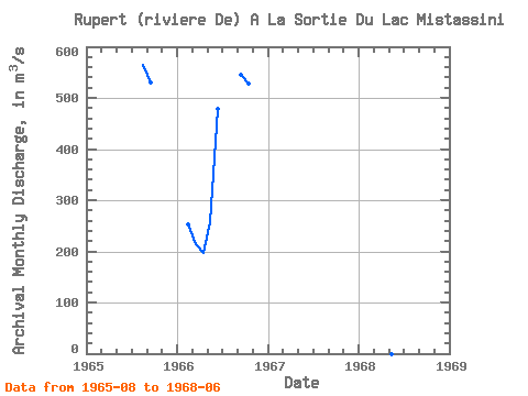
| View: | Statistics | Time Series |
| Units: | mm |
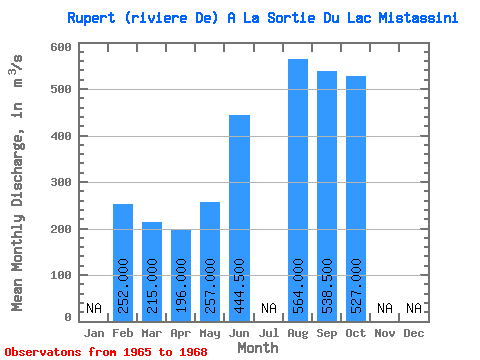
| Statistic | Jan | Feb | Mar | Apr | May | Jun | Jul | Aug | Sep | Oct | Nov | Dec | Annual |
|---|---|---|---|---|---|---|---|---|---|---|---|---|---|
| Mean | 252.00 | 215.00 | 196.00 | 257.00 | 444.50 | 564.00 | 538.50 | 527.00 | |||||
| Standard Deviation | 47.38 | 10.61 | |||||||||||
| Min | 252.00 | 215.00 | 196.00 | 257.00 | 411.00 | 564.00 | 531.00 | 527.00 | |||||
| Max | 252.00 | 215.00 | 196.00 | 257.00 | 478.00 | 564.00 | 546.00 | 527.00 | |||||
| Coefficient of Variation | 0.11 | 0.02 |
| Year | Jan | Feb | Mar | Apr | May | Jun | Jul | Aug | Sep | Oct | Nov | Dec | Annual | 1965 | 564.00 | 531.00 | 1966 | 252.00 | 215.00 | 196.00 | 257.00 | 478.00 | 546.00 | 527.00 | 1968 | 411.00 |
|---|
 Return to R-Arctic Net Home Page