|
|
|||||||||||||||||
| Point ID: 5090 | Downloads | Plots | Site Data | Code: 03AD001 |
|
|
|||||||||||||||||
| Download | |
|---|---|
| Site Descriptor Information | Site Time Series Data |
| Link to all available data | |
|
|
| View: | Statistics | Time Series |
| Units: | mm |
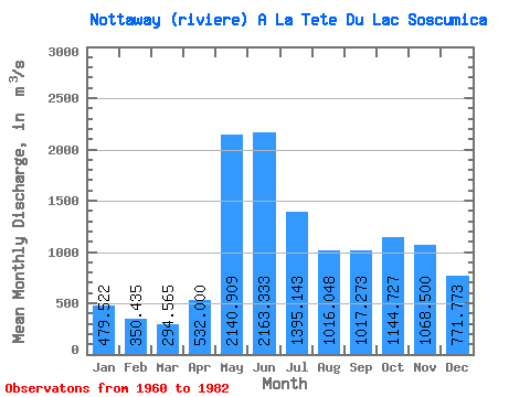
| Statistic | Jan | Feb | Mar | Apr | May | Jun | Jul | Aug | Sep | Oct | Nov | Dec | Annual |
|---|---|---|---|---|---|---|---|---|---|---|---|---|---|
| Mean | 479.52 | 350.44 | 294.56 | 532.00 | 2140.91 | 2163.33 | 1395.14 | 1016.05 | 1017.27 | 1144.73 | 1068.50 | 771.77 | 1032.14 |
| Standard Deviation | 115.96 | 63.68 | 71.07 | 312.04 | 506.65 | 669.20 | 379.84 | 249.88 | 319.37 | 342.88 | 354.40 | 282.37 | 167.92 |
| Min | 296.00 | 237.00 | 190.00 | 183.00 | 1340.00 | 1180.00 | 899.00 | 532.00 | 441.00 | 573.00 | 540.00 | 425.00 | 754.50 |
| Max | 831.00 | 495.00 | 561.00 | 1420.00 | 3320.00 | 4450.00 | 2330.00 | 1420.00 | 1680.00 | 1710.00 | 1760.00 | 1580.00 | 1424.00 |
| Coefficient of Variation | 0.24 | 0.18 | 0.24 | 0.59 | 0.24 | 0.31 | 0.27 | 0.25 | 0.31 | 0.30 | 0.33 | 0.37 | 0.16 |
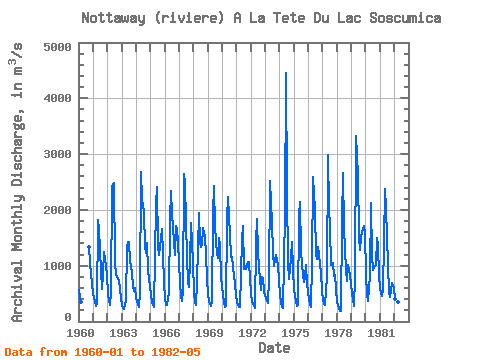
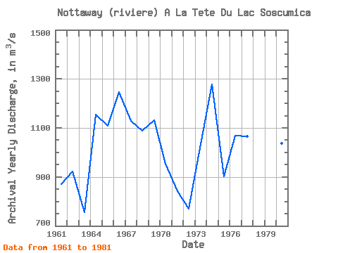
| Year | Jan | Feb | Mar | Apr | May | Jun | Jul | Aug | Sep | Oct | Nov | Dec | Annual | 1960 | 558.00 | 415.00 | 342.00 | 1340.00 | 1050.00 | 844.00 | 664.00 | 1961 | 485.00 | 359.00 | 281.00 | 310.00 | 1820.00 | 1660.00 | 899.00 | 581.00 | 846.00 | 1250.00 | 1120.00 | 833.00 | 870.33 | 1962 | 476.00 | 376.00 | 303.00 | 534.00 | 2410.00 | 2490.00 | 1070.00 | 839.00 | 823.00 | 732.00 | 588.00 | 425.00 | 922.17 | 1963 | 296.00 | 237.00 | 225.00 | 391.00 | 1340.00 | 1420.00 | 1430.00 | 1090.00 | 863.00 | 615.00 | 540.00 | 607.00 | 754.50 | 1964 | 426.00 | 313.00 | 265.00 | 504.00 | 2680.00 | 2180.00 | 1970.00 | 1340.00 | 1220.00 | 1410.00 | 908.00 | 628.00 | 1153.67 | 1965 | 460.00 | 352.00 | 290.00 | 266.00 | 2090.00 | 2410.00 | 1340.00 | 1200.00 | 1330.00 | 1660.00 | 1200.00 | 703.00 | 1108.42 | 1966 | 409.00 | 295.00 | 294.00 | 525.00 | 1800.00 | 2330.00 | 1920.00 | 1420.00 | 1190.00 | 1710.00 | 1640.00 | 1430.00 | 1246.92 | 1967 | 692.00 | 452.00 | 361.00 | 562.00 | 2640.00 | 2470.00 | 1130.00 | 708.00 | 618.00 | 1080.00 | 1760.00 | 1070.00 | 1128.58 | 1968 | 506.00 | 346.00 | 291.00 | 704.00 | 1940.00 | 1400.00 | 1330.00 | 1370.00 | 1680.00 | 1520.00 | 1200.00 | 769.00 | 1088.00 | 1969 | 496.00 | 369.00 | 275.00 | 373.00 | 1950.00 | 2430.00 | 1700.00 | 1210.00 | 1140.00 | 1500.00 | 1350.00 | 794.00 | 1132.25 | 1970 | 474.00 | 358.00 | 268.00 | 283.00 | 1840.00 | 2230.00 | 1550.00 | 1150.00 | 1160.00 | 973.00 | 673.00 | 480.00 | 953.25 | 1971 | 343.00 | 292.00 | 267.00 | 264.00 | 1460.00 | 1710.00 | 949.00 | 994.00 | 943.00 | 1060.00 | 1070.00 | 763.00 | 842.92 | 1972 | 505.00 | 349.00 | 273.00 | 240.00 | 1400.00 | 1840.00 | 1220.00 | 736.00 | 567.00 | 794.00 | 781.00 | 529.00 | 769.50 | 1973 | 413.00 | 364.00 | 328.00 | 766.00 | 2520.00 | 1760.00 | 1220.00 | 994.00 | 1110.00 | 1190.00 | 1020.00 | 721.00 | 1033.83 | 1974 | 478.00 | 338.00 | 260.00 | 247.00 | 1930.00 | 4450.00 | 2330.00 | 1050.00 | 765.00 | 1130.00 | 1430.00 | 937.00 | 1278.75 | 1975 | 563.00 | 375.00 | 276.00 | 300.00 | 1890.00 | 2140.00 | 1250.00 | 821.00 | 707.00 | 804.00 | 1020.00 | 673.00 | 901.58 | 1976 | 397.00 | 296.00 | 262.00 | 1040.00 | 2590.00 | 1990.00 | 1190.00 | 1120.00 | 1330.00 | 1190.00 | 869.00 | 539.00 | 1067.75 | 1977 | 383.00 | 317.00 | 292.00 | 817.00 | 2990.00 | 2030.00 | 1680.00 | 1010.00 | 1040.00 | 823.00 | 830.00 | 581.00 | 1066.08 | 1978 | 349.00 | 241.00 | 190.00 | 183.00 | 1800.00 | 2670.00 | 1670.00 | 916.00 | 727.00 | 1010.00 | 916.00 | 828.00 | 958.33 | 1979 | 502.00 | 378.00 | 278.00 | 780.00 | 3320.00 | 2620.00 | 1510.00 | 1280.00 | 1520.00 | 1610.00 | 1710.00 | 1580.00 | 1424.00 | 1980 | 831.00 | 495.00 | 368.00 | 842.00 | 2130.00 | 1180.00 | 930.00 | 976.00 | 1020.00 | 1500.00 | 1350.00 | 826.00 | 1037.33 | 1981 | 575.00 | 453.00 | 561.00 | 1420.00 | 2370.00 | 2020.00 | 1010.00 | 532.00 | 441.00 | 573.00 | 688.00 | 599.00 | 936.83 | 1982 | 412.00 | 290.00 | 225.00 | 353.00 | 2190.00 |
|---|
 Return to R-Arctic Net Home Page