|
|
|||||||||||||||||
| Point ID: 5079 | Downloads | Plots | Site Data | Code: 03AB001 |
|
|
|||||||||||||||||
| Download | |
|---|---|
| Site Descriptor Information | Site Time Series Data |
| Link to all available data | |
|
|
| View: | Statistics | Time Series |
| Units: | mm |
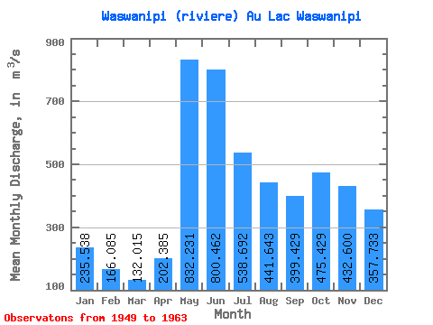
| Statistic | Jan | Feb | Mar | Apr | May | Jun | Jul | Aug | Sep | Oct | Nov | Dec | Annual |
|---|---|---|---|---|---|---|---|---|---|---|---|---|---|
| Mean | 235.54 | 166.09 | 132.01 | 202.38 | 832.23 | 800.46 | 538.69 | 441.64 | 399.43 | 475.43 | 432.60 | 357.73 | 425.77 |
| Standard Deviation | 62.51 | 40.27 | 32.91 | 149.33 | 189.68 | 231.22 | 156.86 | 172.47 | 141.30 | 128.02 | 111.33 | 91.14 | 57.35 |
| Min | 144.00 | 98.10 | 73.20 | 108.00 | 540.00 | 492.00 | 332.00 | 211.00 | 230.00 | 223.00 | 228.00 | 211.00 | 324.01 |
| Max | 363.00 | 254.00 | 187.00 | 680.00 | 1170.00 | 1230.00 | 810.00 | 758.00 | 626.00 | 715.00 | 660.00 | 527.00 | 520.50 |
| Coefficient of Variation | 0.27 | 0.24 | 0.25 | 0.74 | 0.23 | 0.29 | 0.29 | 0.39 | 0.35 | 0.27 | 0.26 | 0.26 | 0.14 |
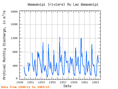
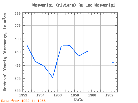
| Year | Jan | Feb | Mar | Apr | May | Jun | Jul | Aug | Sep | Oct | Nov | Dec | Annual | 1949 | 359.00 | 246.00 | 1950 | 187.00 | 149.00 | 121.00 | 123.00 | 477.00 | 230.00 | 304.00 | 479.00 | 419.00 | 1951 | 749.00 | 492.00 | 370.00 | 296.00 | 236.00 | 471.00 | 575.00 | 488.00 | 1952 | 279.00 | 160.00 | 99.90 | 157.00 | 775.00 | 806.00 | 636.00 | 757.00 | 626.00 | 567.00 | 436.00 | 423.00 | 476.82 | 1953 | 320.00 | 212.00 | 180.00 | 680.00 | 1070.00 | 636.00 | 361.00 | 243.00 | 314.00 | 403.00 | 283.00 | 278.00 | 415.00 | 1954 | 172.00 | 98.10 | 73.20 | 151.00 | 1020.00 | 787.00 | 510.00 | 390.00 | 301.00 | 512.00 | 410.00 | 339.00 | 396.94 | 1955 | 212.00 | 164.00 | 139.00 | 236.00 | 846.00 | 597.00 | 332.00 | 237.00 | 245.00 | 395.00 | 486.00 | 362.00 | 354.25 | 1956 | 203.00 | 150.00 | 127.00 | 130.00 | 616.00 | 1230.00 | 665.00 | 500.00 | 621.00 | 715.00 | 427.00 | 290.00 | 472.83 | 1957 | 201.00 | 159.00 | 131.00 | 190.00 | 828.00 | 757.00 | 810.00 | 571.00 | 474.00 | 520.00 | 531.00 | 527.00 | 474.92 | 1958 | 363.00 | 254.00 | 187.00 | 238.00 | 540.00 | 655.00 | 601.00 | 417.00 | 576.00 | 604.00 | 469.00 | 312.00 | 434.67 | 1959 | 198.00 | 154.00 | 123.00 | 108.00 | 861.00 | 924.00 | 548.00 | 389.00 | 456.00 | 575.00 | 660.00 | 435.00 | 452.58 | 1960 | 268.00 | 194.00 | 170.00 | 181.00 | 1170.00 | 1200.00 | 659.00 | 758.00 | 486.00 | 400.00 | 389.00 | 371.00 | 520.50 | 1961 | 240.00 | 168.00 | 135.00 | 178.00 | 822.00 | 686.00 | 335.00 | 211.00 | 352.00 | 542.00 | 440.00 | 395.00 | 375.33 | 1962 | 275.00 | 186.00 | 136.00 | 123.00 | 951.00 | 1020.00 | 470.00 | 433.00 | 390.00 | 425.00 | 317.00 | 211.00 | 411.42 | 1963 | 144.00 | 111.00 | 94.10 | 136.00 | 571.00 | 616.00 | 706.00 | 504.00 | 285.00 | 223.00 | 228.00 | 270.00 | 324.01 |
|---|
 Return to R-Arctic Net Home Page