|
|
|||||||||||||||||
| Point ID: 5077 | Downloads | Plots | Site Data | Code: 03AA002 |
|
|
|||||||||||||||||
| Download | |
|---|---|
| Site Descriptor Information | Site Time Series Data |
| Link to all available data | |
|
|
| View: | Statistics | Time Series |
| Units: | mm |
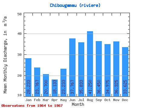
| Statistic | Jan | Feb | Mar | Apr | May | Jun | Jul | Aug | Sep | Oct | Nov | Dec | Annual |
|---|---|---|---|---|---|---|---|---|---|---|---|---|---|
| Mean | 28.23 | 23.77 | 20.70 | 18.13 | 23.23 | 37.77 | 35.83 | 41.25 | 36.45 | 34.98 | 36.33 | 33.62 | 30.11 |
| Standard Deviation | 5.22 | 3.17 | 1.87 | 1.42 | 2.00 | 7.09 | 6.00 | 12.88 | 11.61 | 8.91 | 5.68 | 6.53 | 3.65 |
| Min | 23.30 | 20.40 | 18.70 | 16.50 | 21.20 | 30.30 | 29.30 | 23.60 | 19.80 | 22.00 | 32.00 | 26.90 | 26.24 |
| Max | 33.70 | 26.70 | 22.40 | 19.10 | 25.20 | 44.40 | 41.10 | 54.50 | 46.70 | 41.40 | 44.60 | 42.50 | 33.50 |
| Coefficient of Variation | 0.18 | 0.13 | 0.09 | 0.08 | 0.09 | 0.19 | 0.17 | 0.31 | 0.32 | 0.26 | 0.16 | 0.19 | 0.12 |
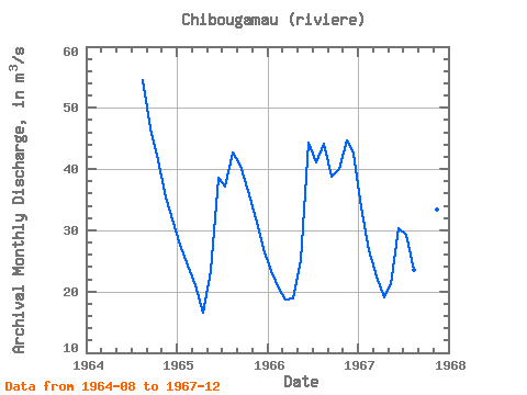
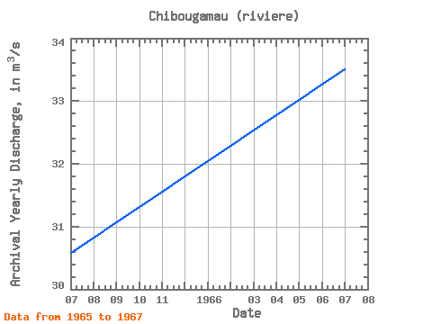
| Year | Jan | Feb | Mar | Apr | May | Jun | Jul | Aug | Sep | Oct | Nov | Dec | Annual | 1964 | 54.50 | 46.70 | 41.40 | 35.30 | 31.70 | 1965 | 27.70 | 24.20 | 21.00 | 16.50 | 23.30 | 38.60 | 37.10 | 42.70 | 40.60 | 36.40 | 32.00 | 26.90 | 30.58 | 1966 | 23.30 | 20.40 | 18.70 | 18.80 | 25.20 | 44.40 | 41.10 | 44.20 | 38.70 | 40.10 | 44.60 | 42.50 | 33.50 | 1967 | 33.70 | 26.70 | 22.40 | 19.10 | 21.20 | 30.30 | 29.30 | 23.60 | 19.80 | 22.00 | 33.40 | 33.40 | 26.24 |
|---|
 Return to R-Arctic Net Home Page