|
|
|||||||||||||||||
| Point ID: 461 | Downloads | Plots | Site Data | Code: 05DC004 |
|
|
|||||||||||||||||
| Download | |
|---|---|
| Site Descriptor Information | Site Time Series Data |
| Link to all available data | |
|
|
| View: | Statistics | Time Series |
| Units: | mm |
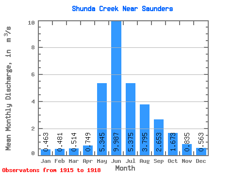
| Statistic | Jan | Feb | Mar | Apr | May | Jun | Jul | Aug | Sep | Oct | Nov | Dec | Annual |
|---|---|---|---|---|---|---|---|---|---|---|---|---|---|
| Mean | 0.46 | 0.48 | 0.51 | 0.75 | 5.34 | 9.99 | 5.38 | 3.79 | 2.65 | 1.67 | 0.83 | 0.56 | 2.45 |
| Standard Deviation | 0.11 | 0.07 | 0.11 | 0.04 | 3.53 | 6.35 | 2.50 | 3.54 | 1.99 | 0.64 | 0.20 | 0.05 | 0.44 |
| Min | 0.34 | 0.43 | 0.39 | 0.72 | 2.85 | 5.83 | 3.61 | 1.29 | 1.40 | 1.03 | 0.67 | 0.53 | 2.14 |
| Max | 0.53 | 0.55 | 0.58 | 0.78 | 7.84 | 17.30 | 7.14 | 6.30 | 4.95 | 2.31 | 1.05 | 0.62 | 2.76 |
| Coefficient of Variation | 0.24 | 0.14 | 0.21 | 0.06 | 0.66 | 0.64 | 0.46 | 0.93 | 0.75 | 0.38 | 0.23 | 0.09 | 0.18 |
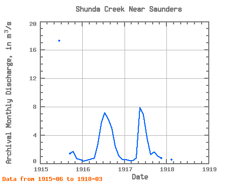
| Year | Jan | Feb | Mar | Apr | May | Jun | Jul | Aug | Sep | Oct | Nov | Dec | Annual | 1915 | 17.30 | 1.40 | 1.68 | 0.67 | 0.53 | 1916 | 0.34 | 0.46 | 0.57 | 0.78 | 2.85 | 5.83 | 7.14 | 6.30 | 4.95 | 2.31 | 1.05 | 0.54 | 2.76 | 1917 | 0.53 | 0.43 | 0.39 | 0.72 | 7.84 | 6.83 | 3.61 | 1.29 | 1.61 | 1.03 | 0.79 | 0.62 | 2.14 | 1918 | 0.52 | 0.55 | 0.58 |
|---|
 Return to R-Arctic Net Home Page