|
|
|||||||||||||||||
| Point ID: 4430 | Downloads | Plots | Site Data | Code: 05QA005 |
|
|
|||||||||||||||||
| Download | |
|---|---|
| Site Descriptor Information | Site Time Series Data |
| Link to all available data | |
|
|
| View: | Statistics | Time Series |
| Units: | mm |
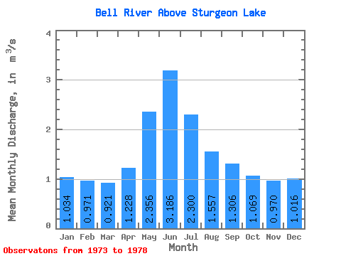
| Statistic | Jan | Feb | Mar | Apr | May | Jun | Jul | Aug | Sep | Oct | Nov | Dec | Annual |
|---|---|---|---|---|---|---|---|---|---|---|---|---|---|
| Mean | 1.03 | 0.97 | 0.92 | 1.23 | 2.36 | 3.19 | 2.30 | 1.56 | 1.31 | 1.07 | 0.97 | 1.02 | 1.45 |
| Standard Deviation | 0.53 | 0.44 | 0.31 | 0.35 | 1.43 | 2.67 | 1.50 | 0.87 | 0.72 | 0.64 | 0.56 | 0.54 | 0.77 |
| Min | 0.22 | 0.33 | 0.47 | 0.72 | 1.11 | 1.23 | 1.04 | 0.63 | 0.21 | 0.08 | 0.10 | 0.16 | 0.79 |
| Max | 1.53 | 1.36 | 1.22 | 1.65 | 4.82 | 7.67 | 4.73 | 2.81 | 2.14 | 1.81 | 1.67 | 1.52 | 2.70 |
| Coefficient of Variation | 0.52 | 0.45 | 0.34 | 0.28 | 0.61 | 0.84 | 0.65 | 0.56 | 0.55 | 0.59 | 0.58 | 0.54 | 0.53 |
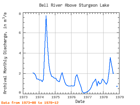
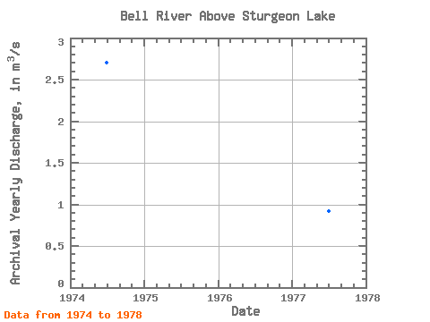
| Year | Jan | Feb | Mar | Apr | May | Jun | Jul | Aug | Sep | Oct | Nov | Dec | Annual | 1973 | 2.05 | 2.01 | 1.81 | 1.46 | 1.44 | 1974 | 1.33 | 1.36 | 1.19 | 1.44 | 4.82 | 7.67 | 4.73 | 2.81 | 2.14 | 1.71 | 1.67 | 1.52 | 2.70 | 1975 | 1.53 | 1.33 | 1.22 | 1.18 | 1.79 | 2.07 | 1.52 | 1.07 | 0.87 | 0.79 | 0.77 | 0.76 | 1.24 | 1976 | 0.78 | 0.75 | 0.79 | 1.65 | 1.87 | 1.40 | 1.04 | 0.63 | 0.21 | 0.08 | 0.10 | 0.16 | 0.79 | 1977 | 0.22 | 0.33 | 0.47 | 0.72 | 1.11 | 1.23 | 1.45 | 0.76 | 1.21 | 0.95 | 1.08 | 1.45 | 0.92 | 1978 | 1.31 | 1.09 | 0.93 | 1.15 | 2.19 | 3.56 | 2.76 | 2.02 | 1.40 | 1.07 | 0.74 | 0.77 | 1.58 |
|---|
 Return to R-Arctic Net Home Page