|
|
|||||||||||||||||
| Point ID: 4422 | Downloads | Plots | Site Data | Code: 05PE008 |
|
|
|||||||||||||||||
| Download | |
|---|---|
| Site Descriptor Information | Site Time Series Data |
| Link to all available data | |
|
|
| View: | Statistics | Time Series |
| Units: | mm |
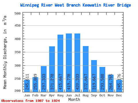
| Statistic | Jan | Feb | Mar | Apr | May | Jun | Jul | Aug | Sep | Oct | Nov | Dec | Annual |
|---|---|---|---|---|---|---|---|---|---|---|---|---|---|
| Mean | 245.61 | 255.89 | 297.33 | 371.28 | 415.67 | 419.78 | 420.33 | 372.67 | 319.67 | 293.59 | 264.76 | 245.18 | 335.25 |
| Standard Deviation | 99.66 | 110.22 | 121.25 | 153.97 | 208.22 | 237.59 | 265.70 | 228.71 | 168.60 | 152.37 | 126.26 | 108.62 | 122.65 |
| Min | 120.00 | 125.00 | 132.00 | 140.00 | 150.00 | 123.00 | 110.00 | 123.00 | 133.00 | 134.00 | 122.00 | 121.00 | 164.50 |
| Max | 527.00 | 503.00 | 570.00 | 594.00 | 872.00 | 1060.00 | 1130.00 | 990.00 | 801.00 | 686.00 | 581.00 | 541.00 | 668.50 |
| Coefficient of Variation | 0.41 | 0.43 | 0.41 | 0.41 | 0.50 | 0.57 | 0.63 | 0.61 | 0.53 | 0.52 | 0.48 | 0.44 | 0.37 |
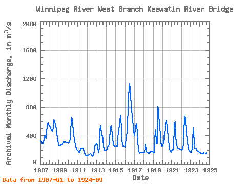
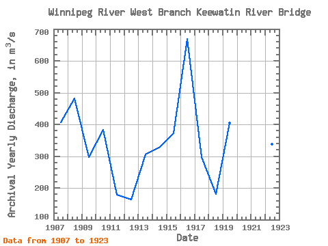
| Year | Jan | Feb | Mar | Apr | May | Jun | Jul | Aug | Sep | Oct | Nov | Dec | Annual | 1907 | 334.00 | 318.00 | 301.00 | 291.00 | 316.00 | 396.00 | 398.00 | 364.00 | 468.00 | 573.00 | 581.00 | 541.00 | 406.75 | 1908 | 527.00 | 495.00 | 474.00 | 463.00 | 506.00 | 628.00 | 599.00 | 556.00 | 498.00 | 419.00 | 345.00 | 281.00 | 482.58 | 1909 | 262.00 | 261.00 | 286.00 | 278.00 | 287.00 | 313.00 | 317.00 | 314.00 | 318.00 | 313.00 | 311.00 | 307.00 | 297.25 | 1910 | 299.00 | 305.00 | 379.00 | 594.00 | 666.00 | 593.00 | 438.00 | 354.00 | 309.00 | 258.00 | 216.00 | 194.00 | 383.75 | 1911 | 183.00 | 166.00 | 163.00 | 223.00 | 218.00 | 225.00 | 225.00 | 204.00 | 160.00 | 134.00 | 122.00 | 121.00 | 178.67 | 1912 | 120.00 | 125.00 | 132.00 | 140.00 | 150.00 | 123.00 | 110.00 | 123.00 | 133.00 | 247.00 | 279.00 | 292.00 | 164.50 | 1913 | 289.00 | 235.00 | 164.00 | 216.00 | 489.00 | 538.00 | 398.00 | 402.00 | 337.00 | 197.00 | 194.00 | 193.00 | 304.33 | 1914 | 196.00 | 208.00 | 264.00 | 255.00 | 325.00 | 498.00 | 542.00 | 490.00 | 358.00 | 297.00 | 254.00 | 245.00 | 327.67 | 1915 | 257.00 | 261.00 | 249.00 | 381.00 | 493.00 | 534.00 | 682.00 | 541.00 | 330.00 | 253.00 | 247.00 | 246.00 | 372.83 | 1916 | 242.00 | 359.00 | 400.00 | 490.00 | 872.00 | 1060.00 | 1130.00 | 990.00 | 801.00 | 686.00 | 542.00 | 450.00 | 668.50 | 1917 | 398.00 | 503.00 | 570.00 | 550.00 | 324.00 | 212.00 | 151.00 | 166.00 | 170.00 | 170.00 | 171.00 | 164.00 | 295.75 | 1918 | 166.00 | 171.00 | 281.00 | 188.00 | 166.00 | 168.00 | 153.00 | 155.00 | 175.00 | 181.00 | 177.00 | 175.00 | 179.67 | 1919 | 162.00 | 163.00 | 373.00 | 484.00 | 293.00 | 298.00 | 808.00 | 756.00 | 521.00 | 445.00 | 303.00 | 252.00 | 404.83 | 1920 | 258.00 | 312.00 | 428.00 | 497.00 | 619.00 | 577.00 | 521.00 | 342.00 | 292.00 | 209.00 | 175.00 | 166.00 | 366.33 | 1921 | 207.00 | 196.00 | 215.00 | 559.00 | 598.00 | 377.00 | 270.00 | 216.00 | 221.00 | 216.00 | 212.00 | 202.00 | 290.75 | 1922 | 197.00 | 209.00 | 204.00 | 416.00 | 675.00 | 639.00 | 442.00 | 371.00 | 308.00 | 212.00 | 190.00 | 177.00 | 336.67 | 1923 | 163.00 | 164.00 | 318.00 | 513.00 | 328.00 | 222.00 | 224.00 | 211.00 | 193.00 | 181.00 | 182.00 | 162.00 | 238.42 | 1924 | 161.00 | 155.00 | 151.00 | 145.00 | 157.00 | 155.00 | 158.00 | 153.00 | 162.00 |
|---|
 Return to R-Arctic Net Home Page