|
|
|||||||||||||||||
| Point ID: 4376 | Downloads | Plots | Site Data | Code: 04MD001 |
|
|
|||||||||||||||||
| Download | |
|---|---|
| Site Descriptor Information | Site Time Series Data |
| Link to all available data | |
|
|
| View: | Statistics | Time Series |
| Units: | mm |
| Statistic | Jan | Feb | Mar | Apr | May | Jun | Jul | Aug | Sep | Oct | Nov | Dec | Annual |
|---|---|---|---|---|---|---|---|---|---|---|---|---|---|
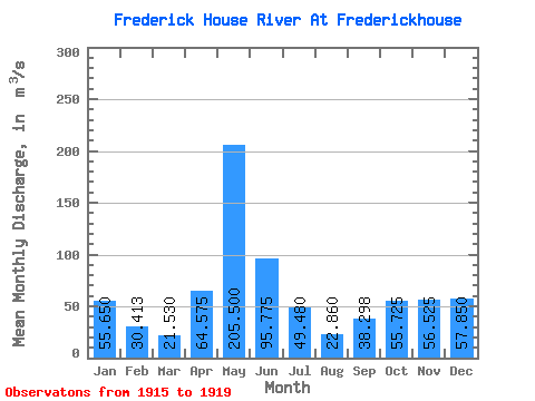
| Mean | 55.65 | 30.41 | 21.53 | 64.58 | 205.50 | 95.78 | 49.48 | 22.86 | 38.30 | 55.73 | 56.52 | 57.85 | 65.37 |
| Standard Deviation | 50.67 | 22.82 | 19.56 | 26.69 | 35.03 | 37.20 | 30.61 | 17.02 | 31.43 | 40.95 | 22.10 | 40.97 | 6.21 |
| Min | 12.80 | 8.45 | 9.12 | 45.20 | 168.00 | 59.30 | 9.22 | 11.90 | 9.29 | 12.40 | 25.60 | 19.80 | 58.20 |
| Max | 126.00 | 59.80 | 50.70 | 102.00 | 241.00 | 145.00 | 76.20 | 53.00 | 89.90 | 102.00 | 78.10 | 116.00 | 69.05 |
| Coefficient of Variation | 0.91 | 0.75 | 0.91 | 0.41 | 0.17 | 0.39 | 0.62 | 0.74 | 0.82 | 0.73 | 0.39 | 0.71 | 0.10 |
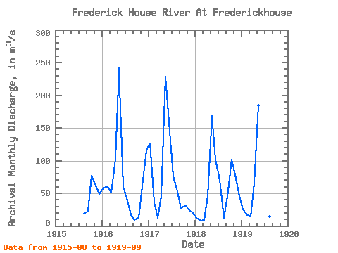
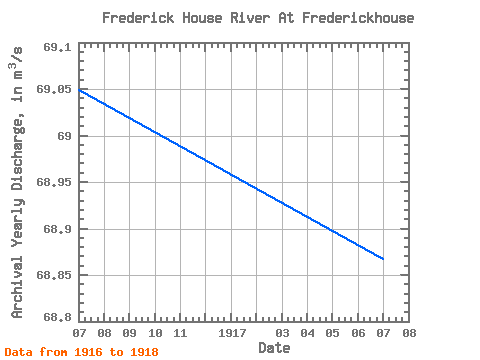
| Year | Jan | Feb | Mar | Apr | May | Jun | Jul | Aug | Sep | Oct | Nov | Dec | Annual | 1915 | 18.50 | 21.90 | 76.70 | 61.40 | 49.40 | 1916 | 58.30 | 59.80 | 50.70 | 102.00 | 241.00 | 59.30 | 42.40 | 16.40 | 9.29 | 12.40 | 61.00 | 116.00 | 69.05 | 1917 | 126.00 | 36.40 | 12.10 | 45.20 | 229.00 | 145.00 | 76.20 | 53.00 | 26.30 | 31.80 | 25.60 | 19.80 | 68.87 | 1918 | 12.80 | 8.45 | 9.12 | 45.60 | 168.00 | 102.00 | 70.10 | 11.90 | 44.10 | 102.00 | 78.10 | 46.20 | 58.20 | 1919 | 25.50 | 17.00 | 14.20 | 65.50 | 184.00 | 76.80 | 9.22 | 14.50 | 89.90 |
|---|
 Return to R-Arctic Net Home Page