|
|
|||||||||||||||||
| Point ID: 4367 | Downloads | Plots | Site Data | Other Close Sites | Code: 04LG002 |
|
|
|||||||||||||||||
| Download | |
|---|---|
| Site Descriptor Information | Site Time Series Data |
| Link to all available data | |
|
|
| View: | Statistics | Time Series |
| Units: | mm |
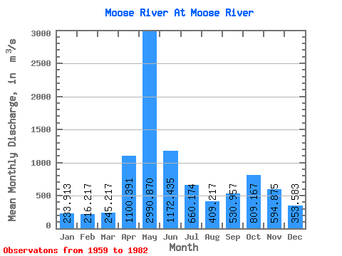
| Statistic | Jan | Feb | Mar | Apr | May | Jun | Jul | Aug | Sep | Oct | Nov | Dec | Annual |
|---|---|---|---|---|---|---|---|---|---|---|---|---|---|
| Mean | 233.91 | 216.22 | 245.22 | 1100.39 | 2990.87 | 1172.43 | 660.17 | 409.22 | 530.96 | 809.17 | 594.88 | 353.58 | 777.07 |
| Standard Deviation | 63.62 | 52.65 | 59.57 | 710.43 | 921.12 | 355.31 | 346.53 | 178.99 | 345.94 | 445.67 | 247.72 | 118.07 | 150.71 |
| Min | 143.00 | 144.00 | 156.00 | 234.00 | 1440.00 | 507.00 | 340.00 | 128.00 | 144.00 | 213.00 | 207.00 | 164.00 | 546.25 |
| Max | 377.00 | 342.00 | 382.00 | 2450.00 | 5310.00 | 1890.00 | 1720.00 | 806.00 | 1550.00 | 1590.00 | 1150.00 | 619.00 | 1088.33 |
| Coefficient of Variation | 0.27 | 0.24 | 0.24 | 0.65 | 0.31 | 0.30 | 0.53 | 0.44 | 0.65 | 0.55 | 0.42 | 0.33 | 0.19 |
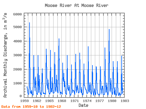
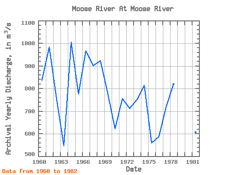
| Year | Jan | Feb | Mar | Apr | May | Jun | Jul | Aug | Sep | Oct | Nov | Dec | Annual | 1959 | 768.00 | 563.00 | 246.00 | 1960 | 199.00 | 228.00 | 228.00 | 923.00 | 5310.00 | 1050.00 | 340.00 | 412.00 | 242.00 | 291.00 | 509.00 | 301.00 | 836.08 | 1961 | 154.00 | 157.00 | 156.00 | 1270.00 | 2970.00 | 1310.00 | 1210.00 | 475.00 | 1280.00 | 1460.00 | 839.00 | 515.00 | 983.00 | 1962 | 285.00 | 232.00 | 215.00 | 376.00 | 2970.00 | 1320.00 | 358.00 | 709.00 | 1550.00 | 450.00 | 301.00 | 301.00 | 755.58 | 1963 | 197.00 | 175.00 | 182.00 | 747.00 | 2040.00 | 1360.00 | 460.00 | 262.00 | 303.00 | 272.00 | 263.00 | 294.00 | 546.25 | 1964 | 224.00 | 230.00 | 230.00 | 1450.00 | 3430.00 | 1720.00 | 925.00 | 786.00 | 575.00 | 1230.00 | 834.00 | 413.00 | 1003.92 | 1965 | 251.00 | 220.00 | 250.00 | 348.00 | 3340.00 | 903.00 | 367.00 | 406.00 | 827.00 | 1410.00 | 594.00 | 394.00 | 775.83 | 1966 | 289.00 | 294.00 | 323.00 | 1590.00 | 3190.00 | 1430.00 | 540.00 | 411.00 | 416.00 | 1590.00 | 893.00 | 619.00 | 965.42 | 1967 | 377.00 | 342.00 | 306.00 | 2130.00 | 4160.00 | 1350.00 | 503.00 | 453.00 | 195.00 | 332.00 | 378.00 | 298.00 | 902.00 | 1968 | 262.00 | 244.00 | 234.00 | 2450.00 | 1440.00 | 1130.00 | 1720.00 | 806.00 | 752.00 | 1120.00 | 633.00 | 284.00 | 922.92 | 1969 | 253.00 | 228.00 | 210.00 | 973.00 | 2980.00 | 1120.00 | 647.00 | 458.00 | 567.00 | 855.00 | 658.00 | 387.00 | 778.00 | 1970 | 192.00 | 144.00 | 157.00 | 300.00 | 2320.00 | 1330.00 | 796.00 | 342.00 | 484.00 | 499.00 | 460.00 | 439.00 | 621.92 | 1971 | 327.00 | 273.00 | 197.00 | 752.00 | 3070.00 | 940.00 | 493.00 | 342.00 | 649.00 | 867.00 | 700.00 | 445.00 | 754.58 | 1972 | 312.00 | 304.00 | 341.00 | 435.00 | 3150.00 | 1300.00 | 675.00 | 368.00 | 336.00 | 708.00 | 395.00 | 211.00 | 711.25 | 1973 | 170.00 | 173.00 | 382.00 | 1430.00 | 2370.00 | 840.00 | 872.00 | 663.00 | 578.00 | 573.00 | 548.00 | 417.00 | 751.33 | 1974 | 312.00 | 269.00 | 293.00 | 360.00 | 3610.00 | 1450.00 | 533.00 | 367.00 | 384.00 | 1040.00 | 767.00 | 359.00 | 812.00 | 1975 | 238.00 | 203.00 | 238.00 | 502.00 | 2270.00 | 1250.00 | 402.00 | 248.00 | 144.00 | 242.00 | 615.00 | 368.00 | 560.00 | 1976 | 245.00 | 182.00 | 230.00 | 2180.00 | 2100.00 | 658.00 | 349.00 | 297.00 | 233.00 | 213.00 | 207.00 | 164.00 | 588.17 | 1977 | 157.00 | 180.00 | 313.00 | 2190.00 | 1700.00 | 564.00 | 605.00 | 231.00 | 782.00 | 676.00 | 801.00 | 437.00 | 719.67 | 1978 | 215.00 | 189.00 | 209.00 | 234.00 | 3520.00 | 1890.00 | 1120.00 | 362.00 | 405.00 | 1020.00 | 429.00 | 237.00 | 819.17 | 1979 | 181.00 | 172.00 | 279.00 | 1620.00 | 4820.00 | 1650.00 | 541.00 | 380.00 | 572.00 | 1350.00 | 1040.00 | 455.00 | 1088.33 | 1980 | 252.00 | 213.00 | 218.00 | 1030.00 | 2540.00 | 928.00 | 360.00 | 194.00 | 213.00 | 709.00 | 361.00 | 177.00 | 599.58 | 1981 | 143.00 | 164.00 | 271.00 | 1700.00 | 2550.00 | 966.00 | 371.00 | 128.00 | 166.00 | 275.00 | 339.00 | 203.00 | 606.33 | 1982 | 145.00 | 157.00 | 178.00 | 319.00 | 2940.00 | 507.00 | 997.00 | 312.00 | 559.00 | 1470.00 | 1150.00 | 522.00 | 771.33 |
|---|
| Other Close Sites | ||||||
|---|---|---|---|---|---|---|
| PointID | Latitude | Longitude | Drainage Area | Source | Name | |
| 4369 | "MOOSE RIVER ABOVE MOOSE RIVER" | 50.74 | -636431 | Hydat | ||
| 4381 | "ABITIBI RIVER AT ONAKAWANA" | 50.60 | -641576 | Hydat | ||
 Return to R-Arctic Net Home Page