|
|
|||||||||||||||||
| Point ID: 435 | Downloads | Plots | Site Data | Code: 05CK002 |
|
|
|||||||||||||||||
| Download | |
|---|---|
| Site Descriptor Information | Site Time Series Data |
| Link to all available data | |
|
|
| View: | Statistics | Time Series |
| Units: | mm |
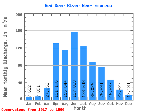
| Statistic | Jan | Feb | Mar | Apr | May | Jun | Jul | Aug | Sep | Oct | Nov | Dec | Annual |
|---|---|---|---|---|---|---|---|---|---|---|---|---|---|
| Mean | 7.63 | 7.89 | 27.06 | 131.11 | 115.64 | 157.07 | 123.65 | 88.03 | 76.59 | 46.90 | 23.82 | 12.13 | 70.28 |
| Standard Deviation | 4.76 | 4.65 | 32.63 | 96.38 | 112.92 | 95.50 | 61.04 | 46.30 | 74.70 | 26.82 | 15.34 | 7.50 | 28.79 |
| Min | 1.64 | 0.98 | 3.20 | 20.20 | 34.50 | 52.70 | 45.10 | 51.90 | 27.00 | 19.40 | 8.08 | 3.23 | 36.71 |
| Max | 20.30 | 18.60 | 140.00 | 412.00 | 591.00 | 475.00 | 358.00 | 282.00 | 362.00 | 135.00 | 66.60 | 28.80 | 136.93 |
| Coefficient of Variation | 0.62 | 0.59 | 1.21 | 0.73 | 0.98 | 0.61 | 0.49 | 0.53 | 0.97 | 0.57 | 0.64 | 0.62 | 0.41 |
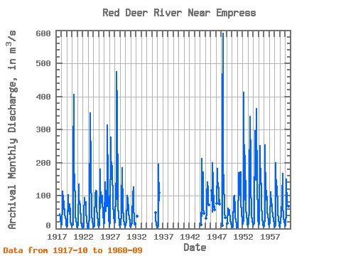
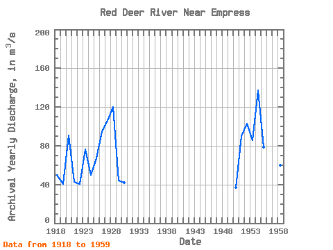
| Year | Jan | Feb | Mar | Apr | May | Jun | Jul | Aug | Sep | Oct | Nov | Dec | Annual | 1917 | 43.30 | 32.20 | 12.30 | 1918 | 12.40 | 12.30 | 73.90 | 112.00 | 58.40 | 99.50 | 65.00 | 51.90 | 40.40 | 38.40 | 22.50 | 8.79 | 49.62 | 1919 | 6.20 | 6.05 | 8.29 | 103.00 | 89.20 | 60.00 | 45.10 | 73.40 | 49.30 | 23.00 | 11.00 | 7.91 | 40.20 | 1920 | 8.45 | 10.70 | 11.40 | 211.00 | 406.00 | 130.00 | 164.00 | 63.30 | 37.60 | 24.90 | 11.80 | 6.26 | 90.45 | 1921 | 4.02 | 5.40 | 10.50 | 135.00 | 82.50 | 82.30 | 68.10 | 54.30 | 32.50 | 19.40 | 9.57 | 4.12 | 42.31 | 1922 | 1.67 | 0.98 | 6.34 | 48.50 | 92.90 | 89.00 | 73.00 | 80.40 | 49.50 | 25.70 | 10.30 | 3.88 | 40.18 | 1923 | 1.64 | 1.56 | 3.20 | 40.90 | 46.60 | 350.00 | 179.00 | 141.00 | 72.90 | 43.00 | 22.20 | 10.10 | 76.01 | 1924 | 3.59 | 5.54 | 6.73 | 32.20 | 97.00 | 102.00 | 114.00 | 113.00 | 57.70 | 39.40 | 19.10 | 9.98 | 50.02 | 1925 | 4.64 | 4.28 | 12.20 | 179.00 | 62.30 | 111.00 | 78.40 | 101.00 | 99.50 | 86.00 | 42.60 | 21.20 | 66.84 | 1926 | 14.60 | 16.10 | 140.00 | 103.00 | 52.70 | 114.00 | 97.70 | 68.10 | 312.00 | 135.00 | 61.20 | 27.60 | 95.17 | 1927 | 16.10 | 7.52 | 20.00 | 277.00 | 162.00 | 201.00 | 179.00 | 137.00 | 126.00 | 79.50 | 36.40 | 23.00 | 105.38 | 1928 | 20.30 | 18.60 | 116.00 | 137.00 | 90.20 | 475.00 | 358.00 | 90.90 | 65.50 | 38.90 | 20.40 | 11.40 | 120.18 | 1929 | 6.21 | 3.88 | 17.70 | 40.70 | 78.20 | 183.00 | 57.20 | 52.30 | 39.70 | 26.80 | 14.40 | 7.05 | 43.93 | 1930 | 4.11 | 12.90 | 23.00 | 55.90 | 55.40 | 99.70 | 87.80 | 57.90 | 47.60 | 31.80 | 22.20 | 8.14 | 42.20 | 1931 | 6.04 | 5.71 | 9.11 | 20.20 | 34.50 | 102.00 | 125.00 | 51.90 | 41.90 | 24.50 | 14.90 | 1932 | 36.90 | 1935 | 48.80 | 34.30 | 8.75 | 6.41 | 1936 | 4.02 | 4.28 | 7.39 | 195.00 | 85.00 | 109.00 | 1944 | 10.90 | 48.20 | 37.40 | 211.00 | 113.00 | 171.00 | 61.80 | 46.20 | 1945 | 30.70 | 43.40 | 97.90 | 141.00 | 117.00 | 74.50 | 73.00 | 72.10 | 1946 | 115.00 | 49.60 | 199.00 | 139.00 | 62.40 | 80.70 | 56.80 | 1947 | 76.30 | 182.00 | 124.00 | 138.00 | 110.00 | 76.30 | 86.40 | 74.90 | 1948 | 10.70 | 345.00 | 591.00 | 215.00 | 113.00 | 92.60 | 45.70 | 34.10 | 1949 | 15.70 | 61.00 | 49.00 | 52.70 | 56.70 | 52.90 | 27.00 | 24.10 | 18.60 | 6.98 | 1950 | 2.91 | 3.44 | 4.94 | 50.60 | 49.60 | 91.70 | 101.00 | 63.10 | 31.90 | 30.00 | 8.08 | 3.23 | 36.71 | 1951 | 3.99 | 3.99 | 3.63 | 167.00 | 168.00 | 135.00 | 172.00 | 103.00 | 172.00 | 80.00 | 46.50 | 27.20 | 90.19 | 1952 | 14.70 | 13.10 | 26.80 | 412.00 | 87.70 | 253.00 | 190.00 | 103.00 | 56.90 | 41.80 | 22.50 | 11.40 | 102.74 | 1953 | 7.08 | 8.84 | 13.70 | 67.10 | 137.00 | 338.00 | 197.00 | 108.00 | 75.20 | 38.80 | 24.40 | 13.60 | 85.73 | 1954 | 10.20 | 11.00 | 18.50 | 105.00 | 207.00 | 296.00 | 147.00 | 282.00 | 362.00 | 109.00 | 66.60 | 28.80 | 136.93 | 1955 | 11.80 | 15.40 | 13.50 | 250.00 | 218.00 | 146.00 | 127.00 | 66.30 | 42.70 | 37.90 | 10.60 | 6.43 | 78.80 | 1956 | 6.56 | 8.40 | 35.50 | 252.00 | 86.60 | 118.00 | 114.00 | 78.10 | 52.20 | 35.70 | 26.90 | 12.90 | 68.91 | 1957 | 8.02 | 6.59 | 21.10 | 111.00 | 100.00 | 85.10 | 62.60 | 55.30 | 42.60 | 37.00 | 29.50 | 14.40 | 47.77 | 1958 | 5.85 | 6.22 | 12.00 | 198.00 | 98.60 | 113.00 | 129.00 | 63.40 | 45.90 | 31.00 | 12.30 | 7.01 | 60.19 | 1959 | 5.22 | 3.26 | 23.70 | 41.90 | 37.40 | 94.60 | 166.00 | 72.70 | 36.30 | 37.40 | 17.70 | 15.40 | 45.97 | 1960 | 8.12 | 9.13 | 55.30 | 150.00 | 68.90 | 91.60 | 87.50 | 67.80 | 37.80 |
|---|
 Return to R-Arctic Net Home Page