|
|
|||||||||||||||||
| Point ID: 4348 | Downloads | Plots | Site Data | Code: 04JA001 |
|
|
|||||||||||||||||
| Download | |
|---|---|
| Site Descriptor Information | Site Time Series Data |
| Link to all available data | |
|
|
| View: | Statistics | Time Series |
| Units: | mm |
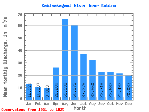
| Statistic | Jan | Feb | Mar | Apr | May | Jun | Jul | Aug | Sep | Oct | Nov | Dec | Annual |
|---|---|---|---|---|---|---|---|---|---|---|---|---|---|
| Mean | 12.92 | 10.40 | 9.88 | 26.20 | 65.53 | 60.38 | 37.27 | 32.56 | 22.72 | 22.68 | 21.49 | 20.03 | 25.26 |
| Standard Deviation | 6.97 | 4.13 | 3.94 | 19.94 | 34.73 | 32.51 | 18.35 | 21.48 | 11.34 | 9.98 | 15.83 | 16.25 | 7.47 |
| Min | 6.06 | 5.69 | 5.35 | 10.70 | 30.00 | 27.10 | 21.20 | 10.20 | 8.09 | 5.71 | 5.97 | 6.60 | 19.98 |
| Max | 20.00 | 13.40 | 12.50 | 48.70 | 99.40 | 105.00 | 62.20 | 62.60 | 37.00 | 32.10 | 43.60 | 38.10 | 30.54 |
| Coefficient of Variation | 0.54 | 0.40 | 0.40 | 0.76 | 0.53 | 0.54 | 0.49 | 0.66 | 0.50 | 0.44 | 0.74 | 0.81 | 0.30 |
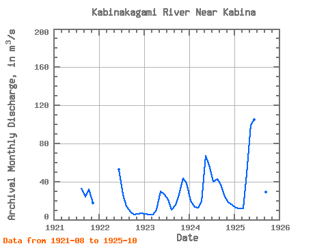
| Year | Jan | Feb | Mar | Apr | May | Jun | Jul | Aug | Sep | Oct | Nov | Dec | Annual | 1921 | 32.70 | 23.70 | 32.10 | 17.80 | 1922 | 52.70 | 26.10 | 14.30 | 8.09 | 5.71 | 5.97 | 6.60 | 1923 | 6.06 | 5.69 | 5.35 | 10.70 | 30.00 | 27.10 | 21.20 | 10.20 | 15.50 | 26.20 | 43.60 | 38.10 | 19.98 | 1924 | 20.00 | 13.40 | 12.50 | 19.20 | 67.20 | 56.70 | 39.60 | 43.00 | 37.00 | 23.90 | 18.60 | 15.40 | 30.54 | 1925 | 12.70 | 12.10 | 11.80 | 48.70 | 99.40 | 105.00 | 62.20 | 62.60 | 29.30 | 25.50 |
|---|
 Return to R-Arctic Net Home Page