|
|
|||||||||||||||||
| Point ID: 4341 | Downloads | Plots | Site Data | Code: 04GB004 |
|
|
|||||||||||||||||
| Download | |
|---|---|
| Site Descriptor Information | Site Time Series Data |
| Link to all available data | |
|
|
| View: | Statistics | Time Series |
| Units: | mm |
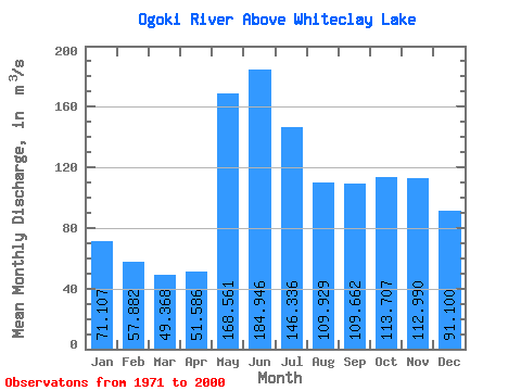
| Statistic | Jan | Feb | Mar | Apr | May | Jun | Jul | Aug | Sep | Oct | Nov | Dec | Annual |
|---|---|---|---|---|---|---|---|---|---|---|---|---|---|
| Mean | 71.11 | 57.88 | 49.37 | 51.59 | 168.56 | 184.95 | 146.34 | 109.93 | 109.66 | 113.71 | 112.99 | 91.10 | 104.83 |
| Standard Deviation | 23.77 | 14.81 | 9.47 | 9.66 | 73.82 | 95.91 | 54.89 | 35.59 | 75.86 | 77.39 | 67.22 | 45.30 | 29.46 |
| Min | 30.70 | 30.00 | 29.60 | 30.70 | 56.50 | 66.30 | 53.00 | 42.10 | 33.90 | 26.90 | 22.50 | 20.10 | 53.15 |
| Max | 124.00 | 87.90 | 72.10 | 76.80 | 363.00 | 539.00 | 292.00 | 167.00 | 346.00 | 319.00 | 295.00 | 206.00 | 169.15 |
| Coefficient of Variation | 0.33 | 0.26 | 0.19 | 0.19 | 0.44 | 0.52 | 0.38 | 0.32 | 0.69 | 0.68 | 0.59 | 0.50 | 0.28 |
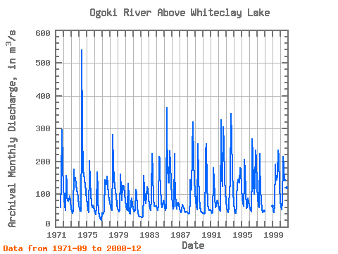
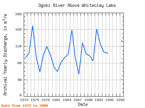
| Year | Jan | Feb | Mar | Apr | May | Jun | Jul | Aug | Sep | Oct | Nov | Dec | Annual | 1971 | 59.60 | 138.00 | 295.00 | 191.00 | 1972 | 119.00 | 85.50 | 64.60 | 50.70 | 156.00 | 137.00 | 91.70 | 81.70 | 78.60 | 83.70 | 93.20 | 76.20 | 93.16 | 1973 | 57.30 | 46.10 | 41.80 | 47.80 | 175.00 | 139.00 | 147.00 | 150.00 | 130.00 | 108.00 | 105.00 | 86.30 | 102.78 | 1974 | 64.90 | 54.40 | 48.40 | 48.10 | 273.00 | 539.00 | 292.00 | 167.00 | 163.00 | 144.00 | 129.00 | 107.00 | 169.15 | 1975 | 83.20 | 69.80 | 54.80 | 44.10 | 180.00 | 201.00 | 137.00 | 99.50 | 70.10 | 60.20 | 66.50 | 58.70 | 93.74 | 1976 | 49.90 | 41.70 | 36.70 | 62.30 | 167.00 | 110.00 | 78.70 | 49.10 | 33.90 | 26.90 | 22.50 | 20.10 | 58.23 | 1977 | 41.70 | 40.00 | 39.80 | 47.80 | 143.00 | 122.00 | 141.00 | 131.00 | 154.00 | 131.00 | 95.70 | 83.90 | 97.58 | 1978 | 73.60 | 63.60 | 54.30 | 51.50 | 180.00 | 281.00 | 186.00 | 147.00 | 124.00 | 106.00 | 95.80 | 67.60 | 119.20 | 1979 | 55.10 | 49.70 | 47.10 | 49.50 | 155.00 | 160.00 | 116.00 | 81.50 | 125.00 | 125.00 | 123.00 | 101.00 | 98.99 | 1980 | 79.10 | 63.40 | 53.10 | 50.30 | 133.00 | 90.50 | 53.00 | 42.10 | 39.10 | 76.90 | 86.20 | 68.50 | 69.60 | 1981 | 58.00 | 49.10 | 45.30 | 50.90 | 106.00 | 112.00 | 99.00 | 62.20 | 41.60 | 33.80 | 30.90 | 30.50 | 59.94 | 1982 | 30.70 | 30.00 | 29.60 | 30.70 | 97.70 | 156.00 | 115.00 | 85.90 | 71.90 | 90.90 | 121.00 | 114.00 | 81.12 | 1983 | 85.90 | 68.10 | 56.60 | 50.00 | 86.20 | 105.00 | 223.00 | 164.00 | 85.00 | 64.30 | 64.10 | 64.00 | 93.02 | 1984 | 63.70 | 56.80 | 49.80 | 64.60 | 213.00 | 207.00 | 164.00 | 119.00 | 73.10 | 60.10 | 62.60 | 79.90 | 101.13 | 1985 | 77.40 | 61.90 | 51.40 | 58.60 | 363.00 | 283.00 | 186.00 | 135.00 | 134.00 | 232.00 | 192.00 | 135.00 | 159.11 | 1986 | 92.20 | 69.10 | 55.90 | 64.30 | 222.00 | 170.00 | 101.00 | 67.70 | 55.50 | 72.70 | 74.80 | 67.10 | 92.69 | 1987 | 55.20 | 47.80 | 43.30 | 49.80 | 67.90 | 66.30 | 61.00 | 60.20 | 51.00 | 44.60 | 45.20 | 45.50 | 53.15 | 1988 | 43.40 | 41.50 | 39.90 | 40.90 | 83.50 | 144.00 | 139.00 | 112.00 | 232.00 | 319.00 | 202.00 | 142.00 | 128.27 | 1989 | 105.00 | 78.00 | 61.30 | 52.90 | 235.00 | 253.00 | 153.00 | 89.00 | 61.80 | 47.70 | 43.30 | 43.30 | 101.94 | 1990 | 42.70 | 41.40 | 39.30 | 41.70 | 167.00 | 226.00 | 253.00 | 130.00 | 69.00 | 55.60 | 50.90 | 52.20 | 97.40 | 1991 | 51.60 | 46.80 | 41.10 | 44.20 | 146.00 | 179.00 | 143.00 | 91.20 | 58.50 | 62.60 | 78.00 | 79.70 | 85.14 | 1992 | 65.80 | 57.70 | 51.30 | 49.30 | 325.00 | 300.00 | 151.00 | 124.00 | 304.00 | 251.00 | 150.00 | 104.00 | 161.09 | 1993 | 78.20 | 60.20 | 48.10 | 43.80 | 56.50 | 67.90 | 109.00 | 136.00 | 346.00 | 273.00 | 171.00 | 108.00 | 124.81 | 1994 | 70.50 | 53.00 | 42.80 | 41.00 | 65.90 | 89.80 | 128.00 | 144.00 | 146.00 | 134.00 | 180.00 | 175.00 | 105.83 | 1995 | 115.00 | 87.70 | 72.10 | 64.00 | 139.00 | 205.00 | 166.00 | 110.00 | 57.40 | 58.90 | 86.60 | 77.10 | 103.23 | 1996 | 64.00 | 56.40 | 51.00 | 46.00 | 168.00 | 268.00 | 217.00 | 132.00 | 101.00 | 133.00 | 234.00 | 206.00 | 139.70 | 1997 | 124.00 | 87.90 | 65.30 | 58.20 | 222.00 | 194.00 | 113.00 | 80.90 | 53.10 | 43.30 | 46.40 | 48.70 | 94.73 | 1999 | 62.90 | 51.10 | 44.50 | 64.60 | 190.00 | 158.00 | 154.00 | 142.00 | 157.00 | 233.00 | 213.00 | 120.00 | 132.51 | 2000 | 81.00 | 62.00 | 53.10 | 76.80 | 204.00 | 215.00 | 180.00 | 144.00 | 105.00 | 88.30 | 119.00 | 89.60 | 118.15 |
|---|
 Return to R-Arctic Net Home Page