|
|
|||||||||||||||||
| Point ID: 4336 | Downloads | Plots | Site Data | Code: 04FB001 |
|
|
|||||||||||||||||
| Download | |
|---|---|
| Site Descriptor Information | Site Time Series Data |
| Link to all available data | |
|
|
| View: | Statistics | Time Series |
| Units: | mm |
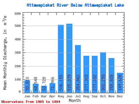
| Statistic | Jan | Feb | Mar | Apr | May | Jun | Jul | Aug | Sep | Oct | Nov | Dec | Annual |
|---|---|---|---|---|---|---|---|---|---|---|---|---|---|
| Mean | 93.81 | 68.55 | 53.73 | 71.97 | 506.15 | 515.38 | 354.86 | 277.30 | 277.03 | 302.29 | 258.83 | 149.63 | 245.32 |
| Standard Deviation | 24.25 | 15.63 | 11.60 | 38.73 | 245.55 | 291.35 | 178.82 | 140.21 | 166.66 | 159.39 | 119.99 | 52.72 | 80.31 |
| Min | 54.10 | 39.60 | 25.20 | 17.70 | 98.50 | 121.00 | 124.00 | 92.80 | 67.90 | 82.20 | 117.00 | 76.90 | 118.58 |
| Max | 151.00 | 97.00 | 82.40 | 242.00 | 1170.00 | 1340.00 | 915.00 | 604.00 | 681.00 | 664.00 | 514.00 | 275.00 | 389.62 |
| Coefficient of Variation | 0.26 | 0.23 | 0.22 | 0.54 | 0.48 | 0.56 | 0.50 | 0.51 | 0.60 | 0.53 | 0.46 | 0.35 | 0.33 |
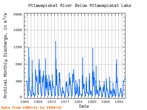
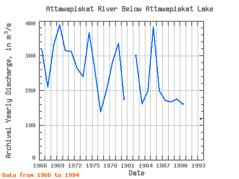
| Year | Jan | Feb | Mar | Apr | May | Jun | Jul | Aug | Sep | Oct | Nov | Dec | Annual | 1965 | 404.00 | 220.00 | 1966 | 127.00 | 84.20 | 62.20 | 60.50 | 691.00 | 1190.00 | 721.00 | 250.00 | 168.00 | 165.00 | 174.00 | 117.00 | 317.49 | 1967 | 76.10 | 54.30 | 49.70 | 65.20 | 457.00 | 892.00 | 282.00 | 221.00 | 115.00 | 82.20 | 121.00 | 107.00 | 210.21 | 1968 | 81.60 | 57.20 | 44.20 | 76.90 | 496.00 | 676.00 | 595.00 | 457.00 | 416.00 | 396.00 | 514.00 | 178.00 | 332.32 | 1969 | 112.00 | 97.00 | 82.40 | 105.00 | 696.00 | 728.00 | 915.00 | 346.00 | 386.00 | 664.00 | 358.00 | 186.00 | 389.62 | 1970 | 118.00 | 85.00 | 64.80 | 57.40 | 452.00 | 502.00 | 369.00 | 413.00 | 480.00 | 644.00 | 405.00 | 179.00 | 314.10 | 1971 | 105.00 | 75.90 | 59.60 | 76.40 | 927.00 | 468.00 | 248.00 | 540.00 | 188.00 | 332.00 | 457.00 | 275.00 | 312.66 | 1972 | 151.00 | 93.40 | 67.20 | 71.70 | 540.00 | 465.00 | 294.00 | 368.00 | 206.00 | 419.00 | 306.00 | 178.00 | 263.27 | 1973 | 111.00 | 77.90 | 61.00 | 64.50 | 553.00 | 398.00 | 397.00 | 262.00 | 272.00 | 255.00 | 261.00 | 172.00 | 240.37 | 1974 | 110.00 | 77.70 | 62.80 | 58.00 | 476.00 | 1340.00 | 527.00 | 310.00 | 680.00 | 377.00 | 230.00 | 146.00 | 366.21 | 1975 | 97.90 | 72.40 | 58.30 | 59.60 | 590.00 | 509.00 | 420.00 | 604.00 | 299.00 | 180.00 | 175.00 | 114.00 | 264.93 | 1976 | 79.30 | 63.00 | 53.30 | 96.90 | 261.00 | 270.00 | 213.00 | 138.00 | 127.00 | 160.00 | 117.00 | 77.60 | 138.01 | 1977 | 54.50 | 41.30 | 34.90 | 75.70 | 245.00 | 312.00 | 383.00 | 291.00 | 379.00 | 278.00 | 182.00 | 139.00 | 201.28 | 1978 | 110.00 | 83.70 | 58.40 | 53.50 | 581.00 | 594.00 | 313.00 | 344.00 | 487.00 | 335.00 | 282.00 | 159.00 | 283.38 | 1979 | 97.90 | 70.40 | 53.40 | 81.60 | 560.00 | 476.00 | 364.00 | 425.00 | 681.00 | 507.00 | 474.00 | 238.00 | 335.69 | 1980 | 146.00 | 96.00 | 60.50 | 99.60 | 418.00 | 193.00 | 124.00 | 108.00 | 134.00 | 349.00 | 244.00 | 127.00 | 174.93 | 1981 | 79.40 | 56.70 | 45.60 | 57.40 | 451.00 | 353.00 | 189.00 | 92.80 | 1982 | 81.00 | 58.20 | 47.50 | 83.50 | 950.00 | 740.00 | 365.00 | 217.00 | 284.00 | 338.00 | 293.00 | 148.00 | 300.43 | 1983 | 90.40 | 67.80 | 56.40 | 55.40 | 214.00 | 261.00 | 483.00 | 222.00 | 116.00 | 123.00 | 133.00 | 108.00 | 160.83 | 1984 | 97.00 | 81.20 | 63.00 | 242.00 | 581.00 | 423.00 | 248.00 | 142.00 | 82.20 | 101.00 | 177.00 | 143.00 | 198.37 | 1985 | 102.00 | 78.80 | 62.50 | 54.40 | 1170.00 | 750.00 | 577.00 | 284.00 | 368.00 | 616.00 | 362.00 | 180.00 | 383.73 | 1986 | 110.00 | 76.60 | 64.80 | 102.00 | 753.00 | 341.00 | 218.00 | 149.00 | 100.00 | 185.00 | 180.00 | 108.00 | 198.95 | 1987 | 80.70 | 65.20 | 52.00 | 88.90 | 413.00 | 247.00 | 185.00 | 197.00 | 280.00 | 194.00 | 160.00 | 98.90 | 171.81 | 1988 | 67.50 | 51.40 | 41.30 | 45.30 | 172.00 | 255.00 | 210.00 | 152.00 | 248.00 | 381.00 | 238.00 | 139.00 | 166.71 | 1989 | 92.30 | 64.90 | 43.70 | 29.70 | 311.00 | 463.00 | 295.00 | 199.00 | 203.00 | 192.00 | 129.00 | 76.90 | 174.96 | 1990 | 54.10 | 39.60 | 25.20 | 17.70 | 298.00 | 501.00 | 301.00 | 141.00 | 87.80 | 143.00 | 179.00 | 148.00 | 161.28 | 1991 | 81.60 | 52.50 | 39.70 | 55.10 | 363.00 | 276.00 | 198.00 | 117.00 | 67.90 | 205.00 | 188.00 | 111.00 | 146.23 | 1992 | 74.60 | 60.40 | 55.00 | 61.30 | 701.00 | 910.00 | 370.00 | 499.00 | 388.00 | 289.00 | 153.00 | 86.80 | 304.01 | 1993 | 61.10 | 52.00 | 45.90 | 45.50 | 98.50 | 121.00 | 125.00 | 146.00 | 243.00 | 220.00 | 159.00 | 106.00 | 118.58 | 1994 | 71.50 | 53.20 | 42.80 | 46.30 | 260.00 | 292.00 | 362.00 | 407.00 | 271.00 | 334.00 | 451.00 | 273.00 | 238.65 |
|---|
 Return to R-Arctic Net Home Page