|
|
|||||||||||||||||
| Point ID: 369 | Downloads | Plots | Site Data | Code: 05CB004 |
|
|
|||||||||||||||||
| Download | |
|---|---|
| Site Descriptor Information | Site Time Series Data |
| Link to all available data | |
| View: | Time Series | All |
| Units: | m3/s |
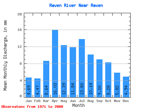
| Statistic | Jan | Feb | Mar | Apr | May | Jun | Jul | Aug | Sep | Oct | Nov | Dec | Annual |
|---|---|---|---|---|---|---|---|---|---|---|---|---|---|
| Mean | 4.62 | 4.43 | 8.50 | 15.79 | 12.20 | 11.65 | 13.59 | 9.98 | 8.86 | 8.15 | 5.73 | 4.87 | 108.32 |
| Standard Deviation | 0.80 | 1.00 | 3.35 | 7.11 | 5.14 | 6.20 | 9.10 | 3.46 | 2.70 | 2.49 | 1.24 | 0.85 | 22.68 |
| Min | 3.49 | 2.95 | 4.47 | 6.77 | 5.79 | 5.77 | 4.00 | 4.30 | 5.41 | 4.39 | 3.35 | 3.30 | 62.83 |
| Max | 7.12 | 7.69 | 17.05 | 34.25 | 28.06 | 35.94 | 48.43 | 19.83 | 18.11 | 18.96 | 9.37 | 6.83 | 168.19 |
| Coefficient of Variation | 0.17 | 0.23 | 0.39 | 0.45 | 0.42 | 0.53 | 0.67 | 0.35 | 0.30 | 0.31 | 0.22 | 0.17 | 0.21 |
 Return to R-Arctic Net Home Page