|
|
|||||||||||||||||
| Point ID: 3673 | Downloads | Plots | Site Data | Code: 10ND005 |
|
|
|||||||||||||||||
| Download | |
|---|---|
| Site Descriptor Information | Site Time Series Data |
| Link to all available data | |
|
|
| View: | Statistics | Time Series |
| Units: | mm |
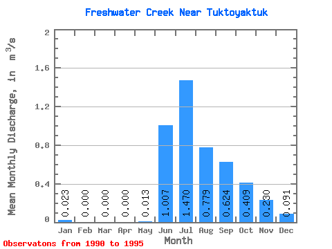
| Statistic | Jan | Feb | Mar | Apr | May | Jun | Jul | Aug | Sep | Oct | Nov | Dec | Annual |
|---|---|---|---|---|---|---|---|---|---|---|---|---|---|
| Mean | 0.02 | 0.00 | 0.00 | 0.00 | 0.01 | 1.01 | 1.47 | 0.78 | 0.62 | 0.41 | 0.23 | 0.09 | 0.42 |
| Standard Deviation | 0.05 | 0.00 | 0.00 | 0.00 | 0.01 | 0.23 | 0.57 | 0.34 | 0.30 | 0.28 | 0.29 | 0.17 | 0.17 |
| Min | 0.00 | 0.00 | 0.00 | 0.00 | 0.00 | 0.83 | 0.94 | 0.47 | 0.26 | 0.07 | 0.00 | 0.00 | 0.25 |
| Max | 0.09 | 0.00 | 0.00 | 0.00 | 0.03 | 1.42 | 2.34 | 1.23 | 0.86 | 0.74 | 0.60 | 0.35 | 0.60 |
| Coefficient of Variation | 2.00 | 1.05 | 0.23 | 0.39 | 0.44 | 0.47 | 0.68 | 1.25 | 1.89 | 0.39 |
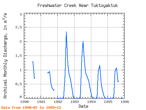
| Year | Jan | Feb | Mar | Apr | May | Jun | Jul | Aug | Sep | Oct | Nov | Dec | Annual | 1990 | 1.30 | 0.71 | 1991 | 0.90 | 0.94 | 0.47 | 0.34 | 0.28 | 1992 | 0.00 | 0.00 | 0.00 | 0.00 | 0.00 | 0.83 | 2.34 | 1.19 | 0.85 | 0.65 | 0.32 | 0.01 | 0.52 | 1993 | 0.00 | 0.00 | 0.00 | 0.00 | 0.02 | 1.42 | 2.01 | 1.23 | 0.86 | 0.74 | 0.60 | 0.35 | 0.60 | 1994 | 0.09 | 0.00 | 0.00 | 0.00 | 0.00 | 0.95 | 1.16 | 0.49 | 0.26 | 0.07 | 0.00 | 0.00 | 0.25 | 1995 | 0.00 | 0.00 | 0.00 | 0.00 | 0.03 | 0.94 | 1.07 | 0.58 | 0.81 | 0.31 | 0.01 | 0.00 | 0.31 |
|---|
 Return to R-Arctic Net Home Page