|
|
|||||||||||||||||
| Point ID: 3670 | Downloads | Plots | Site Data | Code: 10ND002 |
|
|
|||||||||||||||||
| Download | |
|---|---|
| Site Descriptor Information | Site Time Series Data |
| Link to all available data | |
| View: | Time Series | All |
| Units: | m3/s |
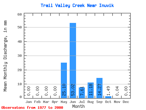
| Statistic | Jan | Feb | Mar | Apr | May | Jun | Jul | Aug | Sep | Oct | Nov | Dec | Annual |
|---|---|---|---|---|---|---|---|---|---|---|---|---|---|
| Mean | 0.00 | 0.00 | 0.00 | 0.00 | 25.11 | 53.01 | 7.59 | 11.17 | 14.28 | 1.48 | 0.03 | 0.00 | 104.65 |
| Standard Deviation | 0.00 | 0.00 | 0.00 | 0.00 | 24.61 | 27.14 | 11.17 | 10.21 | 13.06 | 1.49 | 0.12 | 0.01 | 33.43 |
| Min | 0.00 | 0.00 | 0.00 | 0.00 | 0.00 | 5.96 | 0.31 | 0.04 | 0.00 | 0.00 | 0.00 | 0.00 | 60.76 |
| Max | 0.00 | 0.00 | 0.00 | 0.00 | 83.12 | 109.30 | 44.70 | 28.86 | 42.50 | 4.24 | 0.53 | 0.04 | 199.16 |
| Coefficient of Variation | 0.98 | 0.51 | 1.47 | 0.91 | 0.91 | 1.01 | 3.60 | 4.58 | 0.32 |
 Return to R-Arctic Net Home Page