|
|
|||||||||||||||||
| Point ID: 3663 | Downloads | Plots | Site Data | Code: 10MC003 |
|
|
|||||||||||||||||
| Download | |
|---|---|
| Site Descriptor Information | Site Time Series Data |
| Link to all available data | |
|
|
| View: | Statistics | Time Series |
| Units: | mm |
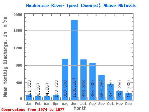
| Statistic | Jan | Feb | Mar | Apr | May | Jun | Jul | Aug | Sep | Oct | Nov | Dec | Annual |
|---|---|---|---|---|---|---|---|---|---|---|---|---|---|
| Mean | 121.33 | 96.37 | 94.87 | 109.73 | 950.50 | 1836.67 | 933.33 | 856.00 | 580.75 | 374.75 | 207.25 | 154.00 | 513.40 |
| Standard Deviation | 9.07 | 23.40 | 13.33 | 10.40 | 154.86 | 151.44 | 80.43 | 298.34 | 68.78 | 43.34 | 36.07 | 29.13 | 41.64 |
| Min | 113.00 | 70.10 | 80.10 | 99.20 | 841.00 | 1730.00 | 844.00 | 668.00 | 520.00 | 334.00 | 172.00 | 116.00 | 483.96 |
| Max | 131.00 | 115.00 | 106.00 | 120.00 | 1060.00 | 2010.00 | 1000.00 | 1200.00 | 667.00 | 436.00 | 253.00 | 183.00 | 542.85 |
| Coefficient of Variation | 0.07 | 0.24 | 0.14 | 0.10 | 0.16 | 0.08 | 0.09 | 0.35 | 0.12 | 0.12 | 0.17 | 0.19 | 0.08 |
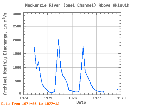
| Year | Jan | Feb | Mar | Apr | May | Jun | Jul | Aug | Sep | Oct | Nov | Dec | Annual | 1974 | 1730.00 | 956.00 | 1200.00 | 667.00 | 367.00 | 253.00 | 183.00 | 1975 | 113.00 | 70.10 | 80.10 | 120.00 | 1060.00 | 2010.00 | 1000.00 | 700.00 | 605.00 | 436.00 | 172.00 | 148.00 | 542.85 | 1976 | 120.00 | 104.00 | 98.50 | 110.00 | 841.00 | 1770.00 | 844.00 | 668.00 | 531.00 | 334.00 | 218.00 | 169.00 | 483.96 | 1977 | 131.00 | 115.00 | 106.00 | 99.20 | 520.00 | 362.00 | 186.00 | 116.00 |
|---|
 Return to R-Arctic Net Home Page