|
|
|||||||||||||||||
| Point ID: 3661 | Downloads | Plots | Site Data | Code: 10LD002 |
|
|
|||||||||||||||||
| Download | |
|---|---|
| Site Descriptor Information | Site Time Series Data |
| Link to all available data | |
|
|
| View: | Statistics | Time Series |
| Units: | mm |
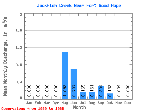
| Statistic | Jan | Feb | Mar | Apr | May | Jun | Jul | Aug | Sep | Oct | Nov | Dec | Annual |
|---|---|---|---|---|---|---|---|---|---|---|---|---|---|
| Mean | 0.00 | 0.00 | 0.00 | 0.00 | 1.09 | 0.71 | 0.17 | 0.16 | 0.30 | 0.13 | 0.00 | 0.00 | 0.23 |
| Standard Deviation | 0.00 | 0.00 | 0.00 | 0.00 | 0.60 | 0.28 | 0.14 | 0.19 | 0.48 | 0.20 | 0.01 | 0.00 | 0.07 |
| Min | 0.00 | 0.00 | 0.00 | 0.00 | 0.48 | 0.33 | 0.04 | 0.01 | 0.04 | 0.02 | 0.00 | 0.00 | 0.12 |
| Max | 0.00 | 0.00 | 0.00 | 0.00 | 2.15 | 1.00 | 0.41 | 0.44 | 1.33 | 0.56 | 0.01 | 0.00 | 0.28 |
| Coefficient of Variation | 0.55 | 0.39 | 0.82 | 1.17 | 1.59 | 1.47 | 1.70 | 0.29 |
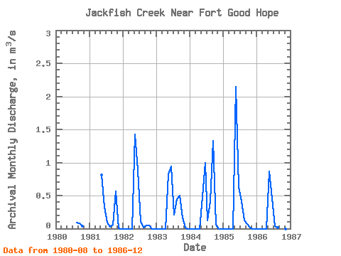
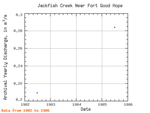
| Year | Jan | Feb | Mar | Apr | May | Jun | Jul | Aug | Sep | Oct | Nov | Dec | Annual | 1980 | 0.09 | 0.08 | 0.04 | 1981 | 0.81 | 0.33 | 0.09 | 0.03 | 0.06 | 0.56 | 0.01 | 0.00 | 1982 | 0.00 | 0.00 | 0.00 | 0.00 | 1.42 | 0.89 | 0.10 | 0.01 | 0.04 | 0.04 | 0.00 | 0.00 | 0.21 | 1983 | 0.00 | 0.00 | 0.00 | 0.00 | 0.82 | 0.94 | 0.21 | 0.44 | 0.50 | 0.16 | 0.01 | 0.00 | 0.26 | 1984 | 0.00 | 0.00 | 0.00 | 0.00 | 0.48 | 1.00 | 0.13 | 0.42 | 1.33 | 0.06 | 0.00 | 0.00 | 0.28 | 1985 | 0.00 | 0.00 | 0.00 | 0.00 | 2.15 | 0.63 | 0.41 | 0.12 | 0.07 | 0.02 | 0.00 | 0.00 | 0.28 | 1986 | 0.00 | 0.00 | 0.00 | 0.00 | 0.87 | 0.46 | 0.04 | 0.01 | 0.04 | 0.04 | 0.00 | 0.00 | 0.12 |
|---|
 Return to R-Arctic Net Home Page