|
|
|||||||||||||||||
| Point ID: 3657 | Downloads | Plots | Site Data | Code: 10LC008 |
|
|
|||||||||||||||||
| Download | |
|---|---|
| Site Descriptor Information | Site Time Series Data |
| Link to all available data | |
|
|
| View: | Statistics | Time Series |
| Units: | mm |
| Statistic | Jan | Feb | Mar | Apr | May | Jun | Jul | Aug | Sep | Oct | Nov | Dec | Annual |
|---|---|---|---|---|---|---|---|---|---|---|---|---|---|
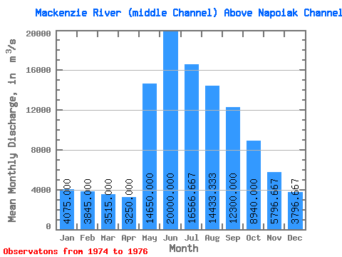
| Mean | 4075.00 | 3845.00 | 3515.00 | 3250.00 | 14650.00 | 20000.00 | 16566.67 | 14433.33 | 12300.00 | 8940.00 | 5796.67 | 3796.67 | 8700.83 |
| Standard Deviation | 671.75 | 346.48 | 162.63 | 14.14 | 2050.61 | 2381.17 | 1401.19 | 3696.39 | 1808.31 | 1583.70 | 3101.71 | 1827.80 | 40.07 |
| Min | 3600.00 | 3600.00 | 3400.00 | 3240.00 | 13200.00 | 18200.00 | 15000.00 | 12200.00 | 10400.00 | 7630.00 | 3800.00 | 2180.00 | 8672.50 |
| Max | 4550.00 | 4090.00 | 3630.00 | 3260.00 | 16100.00 | 22700.00 | 17700.00 | 18700.00 | 14000.00 | 10700.00 | 9370.00 | 5780.00 | 8729.17 |
| Coefficient of Variation | 0.17 | 0.09 | 0.05 | 0.00 | 0.14 | 0.12 | 0.09 | 0.26 | 0.15 | 0.18 | 0.54 | 0.48 | 0.01 |
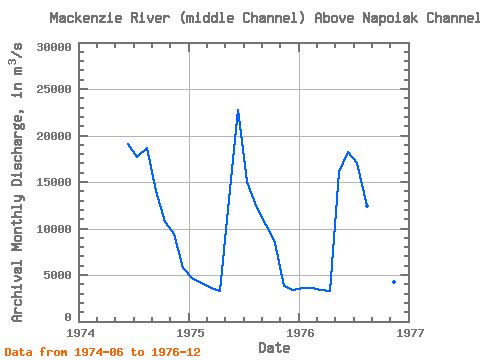
| Year | Jan | Feb | Mar | Apr | May | Jun | Jul | Aug | Sep | Oct | Nov | Dec | Annual | 1974 | 19100.00 | 17700.00 | 18700.00 | 14000.00 | 10700.00 | 9370.00 | 5780.00 | 1975 | 4550.00 | 4090.00 | 3630.00 | 3260.00 | 13200.00 | 22700.00 | 15000.00 | 12200.00 | 10400.00 | 8490.00 | 3800.00 | 3430.00 | 8729.17 | 1976 | 3600.00 | 3600.00 | 3400.00 | 3240.00 | 16100.00 | 18200.00 | 17000.00 | 12400.00 | 12500.00 | 7630.00 | 4220.00 | 2180.00 | 8672.50 |
|---|
 Return to R-Arctic Net Home Page