|
|
|||||||||||||||||
| Point ID: 3654 | Downloads | Plots | Site Data | Code: 10LC004 |
|
|
|||||||||||||||||
| Download | |
|---|---|
| Site Descriptor Information | Site Time Series Data |
| Link to all available data | |
|
|
| View: | Statistics | Time Series |
| Units: | mm |
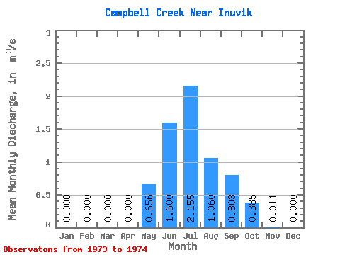
| Statistic | Jan | Feb | Mar | Apr | May | Jun | Jul | Aug | Sep | Oct | Nov | Dec | Annual |
|---|---|---|---|---|---|---|---|---|---|---|---|---|---|
| Mean | 0.00 | 0.00 | 0.00 | 0.00 | 0.66 | 1.60 | 2.15 | 1.06 | 0.80 | 0.39 | 0.01 | 0.00 | 0.58 |
| Standard Deviation | 0.83 | 0.52 | 0.58 | 0.28 | 0.02 | 0.00 | |||||||
| Min | 0.00 | 0.00 | 0.00 | 0.00 | 0.66 | 1.60 | 1.57 | 0.69 | 0.40 | 0.19 | 0.00 | 0.00 | 0.58 |
| Max | 0.00 | 0.00 | 0.00 | 0.00 | 0.66 | 1.60 | 2.74 | 1.43 | 1.21 | 0.58 | 0.02 | 0.00 | 0.58 |
| Coefficient of Variation | 0.38 | 0.49 | 0.72 | 0.72 | 1.41 |
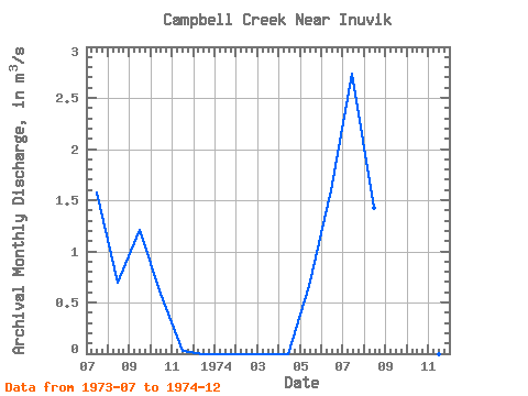
| Year | Jan | Feb | Mar | Apr | May | Jun | Jul | Aug | Sep | Oct | Nov | Dec | Annual | 1973 | 1.57 | 0.69 | 1.21 | 0.58 | 0.02 | 0.00 | 1974 | 0.00 | 0.00 | 0.00 | 0.00 | 0.66 | 1.60 | 2.74 | 1.43 | 0.40 | 0.19 | 0.00 | 0.00 | 0.58 |
|---|
 Return to R-Arctic Net Home Page