|
|
|||||||||||||||||
| Point ID: 3648 | Downloads | Plots | Site Data | Code: 10KC001 |
|
|
|||||||||||||||||
| Download | |
|---|---|
| Site Descriptor Information | Site Time Series Data |
| Link to all available data | |
|
|
| View: | Statistics | Time Series |
| Units: | mm |
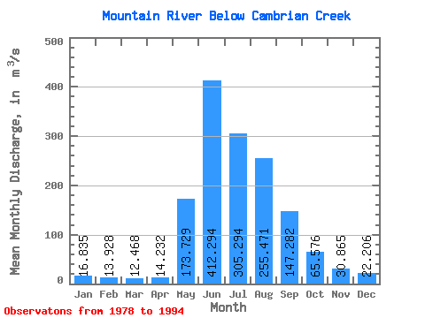
| Statistic | Jan | Feb | Mar | Apr | May | Jun | Jul | Aug | Sep | Oct | Nov | Dec | Annual |
|---|---|---|---|---|---|---|---|---|---|---|---|---|---|
| Mean | 16.84 | 13.93 | 12.47 | 14.23 | 173.73 | 412.29 | 305.29 | 255.47 | 147.28 | 65.58 | 30.86 | 22.21 | 122.52 |
| Standard Deviation | 3.10 | 3.09 | 3.04 | 3.99 | 57.47 | 85.80 | 78.49 | 82.57 | 45.45 | 15.53 | 4.56 | 3.25 | 14.70 |
| Min | 11.50 | 9.66 | 8.66 | 9.03 | 88.40 | 266.00 | 171.00 | 165.00 | 84.10 | 40.20 | 24.20 | 16.60 | 103.31 |
| Max | 20.90 | 18.60 | 18.30 | 22.80 | 275.00 | 575.00 | 419.00 | 439.00 | 241.00 | 99.70 | 39.70 | 28.00 | 163.32 |
| Coefficient of Variation | 0.18 | 0.22 | 0.24 | 0.28 | 0.33 | 0.21 | 0.26 | 0.32 | 0.31 | 0.24 | 0.15 | 0.15 | 0.12 |
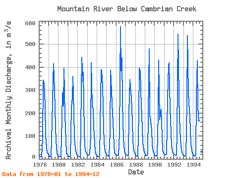
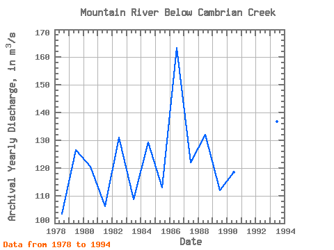
| Year | Jan | Feb | Mar | Apr | May | Jun | Jul | Aug | Sep | Oct | Nov | Dec | Annual | 1978 | 13.10 | 11.10 | 9.54 | 9.03 | 88.40 | 344.00 | 328.00 | 235.00 | 101.00 | 48.20 | 27.70 | 24.70 | 103.31 | 1979 | 16.60 | 9.93 | 8.69 | 11.10 | 160.00 | 340.00 | 413.00 | 299.00 | 144.00 | 75.50 | 24.20 | 16.60 | 126.55 | 1980 | 11.50 | 9.66 | 9.18 | 12.50 | 175.00 | 287.00 | 230.00 | 395.00 | 192.00 | 79.00 | 26.80 | 16.60 | 120.35 | 1981 | 11.90 | 10.90 | 10.30 | 10.30 | 222.00 | 266.00 | 357.00 | 205.00 | 89.70 | 46.80 | 25.70 | 18.60 | 106.18 | 1982 | 13.70 | 10.30 | 8.66 | 9.51 | 144.00 | 442.00 | 336.00 | 377.00 | 120.00 | 54.90 | 32.20 | 22.30 | 130.88 | 1983 | 18.60 | 16.90 | 16.10 | 22.80 | 103.00 | 418.00 | 229.00 | 219.00 | 138.00 | 71.40 | 31.00 | 18.90 | 108.56 | 1984 | 13.10 | 9.69 | 8.68 | 14.50 | 151.00 | 389.00 | 387.00 | 314.00 | 140.00 | 69.20 | 31.90 | 22.00 | 129.17 | 1985 | 17.60 | 15.10 | 12.90 | 11.80 | 114.00 | 386.00 | 295.00 | 239.00 | 157.00 | 61.20 | 25.20 | 21.10 | 112.99 | 1986 | 18.90 | 17.00 | 15.30 | 13.70 | 108.00 | 575.00 | 384.00 | 439.00 | 241.00 | 88.10 | 34.10 | 25.80 | 163.32 | 1987 | 20.90 | 17.00 | 14.00 | 14.20 | 201.00 | 345.00 | 282.00 | 270.00 | 162.00 | 76.20 | 36.30 | 24.00 | 121.88 | 1988 | 17.90 | 14.20 | 11.80 | 11.60 | 193.00 | 395.00 | 382.00 | 227.00 | 193.00 | 69.40 | 39.70 | 28.00 | 131.88 | 1989 | 20.70 | 16.50 | 14.80 | 19.30 | 198.00 | 479.00 | 192.00 | 165.00 | 125.00 | 60.70 | 30.60 | 21.70 | 111.94 | 1990 | 16.90 | 14.10 | 12.70 | 13.40 | 194.00 | 429.00 | 171.00 | 191.00 | 216.00 | 99.70 | 37.40 | 24.70 | 118.33 | 1991 | 20.10 | 18.60 | 18.30 | 20.40 | 265.00 | 408.00 | 419.00 | 218.00 | 116.00 | 53.80 | 29.90 | 24.30 | 134.28 | 1992 | 19.60 | 17.40 | 16.50 | 15.10 | 118.00 | 542.00 | 275.00 | 177.00 | 84.10 | 40.20 | 26.20 | 19.90 | 112.58 | 1993 | 16.20 | 13.80 | 12.50 | 13.50 | 244.00 | 537.00 | 288.00 | 207.00 | 183.00 | 66.60 | 35.00 | 25.10 | 136.81 | 1994 | 18.90 | 14.60 | 12.00 | 19.20 | 275.00 | 427.00 | 222.00 | 166.00 | 102.00 | 53.90 | 30.80 | 23.20 | 113.72 |
|---|
 Return to R-Arctic Net Home Page