|
|
|||||||||||||||||
| Point ID: 3633 | Downloads | Plots | Site Data | Code: 10HC005 |
|
|
|||||||||||||||||
| Download | |
|---|---|
| Site Descriptor Information | Site Time Series Data |
| Link to all available data | |
|
|
| View: | Statistics | Time Series |
| Units: | mm |
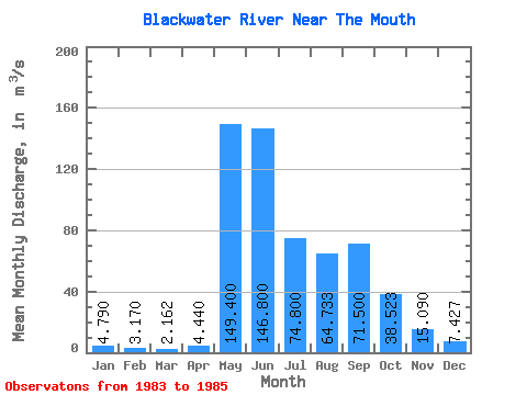
| Statistic | Jan | Feb | Mar | Apr | May | Jun | Jul | Aug | Sep | Oct | Nov | Dec | Annual |
|---|---|---|---|---|---|---|---|---|---|---|---|---|---|
| Mean | 4.79 | 3.17 | 2.16 | 4.44 | 149.40 | 146.80 | 74.80 | 64.73 | 71.50 | 38.52 | 15.09 | 7.43 | 53.76 |
| Standard Deviation | 4.50 | 2.52 | 1.99 | 1.99 | 89.94 | 89.74 | 10.96 | 54.67 | 79.31 | 39.53 | 16.88 | 7.32 | 0.36 |
| Min | 1.61 | 1.39 | 0.75 | 3.03 | 85.80 | 45.40 | 62.40 | 24.60 | 14.10 | 8.47 | 3.87 | 1.80 | 53.51 |
| Max | 7.97 | 4.95 | 3.57 | 5.85 | 213.00 | 216.00 | 83.20 | 127.00 | 162.00 | 83.30 | 34.50 | 15.70 | 54.02 |
| Coefficient of Variation | 0.94 | 0.79 | 0.92 | 0.45 | 0.60 | 0.61 | 0.15 | 0.84 | 1.11 | 1.03 | 1.12 | 0.98 | 0.01 |
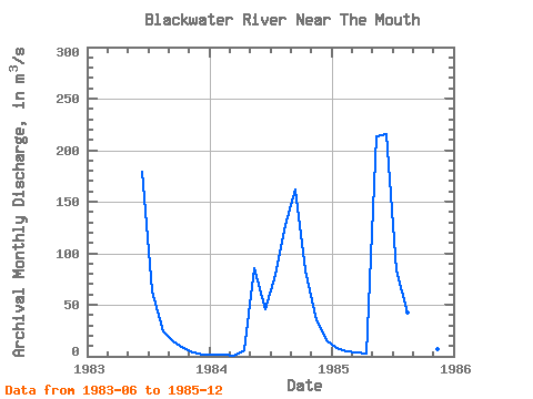
| Year | Jan | Feb | Mar | Apr | May | Jun | Jul | Aug | Sep | Oct | Nov | Dec | Annual | 1983 | 179.00 | 62.40 | 24.60 | 14.10 | 8.47 | 3.87 | 1.80 | 1984 | 1.61 | 1.39 | 0.75 | 5.85 | 85.80 | 45.40 | 78.80 | 127.00 | 162.00 | 83.30 | 34.50 | 15.70 | 53.51 | 1985 | 7.97 | 4.95 | 3.57 | 3.03 | 213.00 | 216.00 | 83.20 | 42.60 | 38.40 | 23.80 | 6.90 | 4.78 | 54.02 |
|---|
 Return to R-Arctic Net Home Page