|
|
| Point ID: 3619 | Downloads | Plots | Site Data | Other Close Sites | Code: 10GB001 |
|
| Download | |
|---|---|
| Site Descriptor Information | Site Time Series Data |
| Link to all available data | |
|
|
|
| View: | Statistics | All |
| Units: | mm |
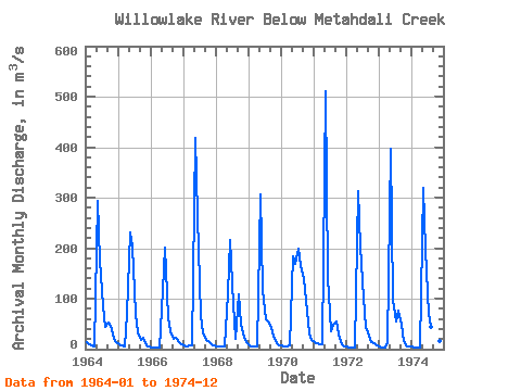
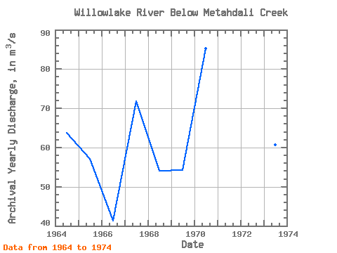
| Year | Jan | Feb | Mar | Apr | May | Jun | Jul | Aug | Sep | Oct | Nov | Dec | Annual | 1964 | 13.40 | 8.78 | 6.82 | 5.49 | 294.00 | 176.00 | 84.50 | 43.60 | 52.50 | 45.70 | 20.90 | 13.50 | 63.77 | 1965 | 10.50 | 7.77 | 5.02 | 69.20 | 232.00 | 204.00 | 69.30 | 32.40 | 19.00 | 23.00 | 7.77 | 4.68 | 57.05 | 1966 | 3.05 | 3.12 | 2.32 | 2.35 | 118.00 | 201.00 | 64.30 | 35.10 | 19.40 | 23.50 | 13.40 | 9.74 | 41.27 | 1967 | 7.20 | 6.21 | 7.01 | 8.37 | 419.00 | 263.00 | 65.70 | 32.80 | 18.80 | 16.40 | 9.69 | 7.04 | 71.77 | 1968 | 5.22 | 5.21 | 5.10 | 4.69 | 111.00 | 216.00 | 88.40 | 19.80 | 108.00 | 49.00 | 21.70 | 13.80 | 53.99 | 1969 | 8.31 | 5.66 | 4.90 | 5.86 | 306.00 | 117.00 | 58.40 | 55.90 | 42.90 | 25.80 | 12.10 | 8.25 | 54.26 | 1970 | 6.83 | 5.84 | 5.20 | 6.84 | 183.00 | 168.00 | 199.00 | 164.00 | 138.00 | 96.80 | 30.50 | 19.30 | 85.28 | 1971 | 14.90 | 12.00 | 9.26 | 10.10 | 510.00 | 143.00 | 36.50 | 48.60 | 55.00 | 30.00 | 9.52 | 5.09 | 73.66 | 1972 | 4.53 | 4.26 | 3.86 | 3.64 | 313.00 | 203.00 | 102.00 | 44.30 | 26.70 | 14.30 | 11.20 | 7.43 | 61.52 | 1973 | 5.08 | 3.75 | 3.88 | 13.80 | 397.00 | 98.30 | 54.00 | 76.70 | 48.60 | 17.20 | 4.38 | 4.85 | 60.63 | 1974 | 4.73 | 3.71 | 3.37 | 3.74 | 320.00 | 197.00 | 70.70 | 45.10 | 41.50 | 26.20 | 15.30 | 8.65 | 61.67 |
|---|
| Other Close Sites | ||||||
|---|---|---|---|---|---|---|
| PointID | Latitude | Longitude | Drainage Area | Source | Name | |
| 3621 | "WILLOWLAKE RIVER ABOVE METAHDALI CREEK" | 62.65 | 1635870 | Hydat | ||
 Return to R-Arctic Net Home Page