|
|
|||||||||||||||||
| Point ID: 3614 | Downloads | Plots | Site Data | Code: 10FB001 |
|
|
|||||||||||||||||
| Download | |
|---|---|
| Site Descriptor Information | Site Time Series Data |
| Link to all available data | |
|
|
| View: | Statistics | Time Series |
| Units: | mm |
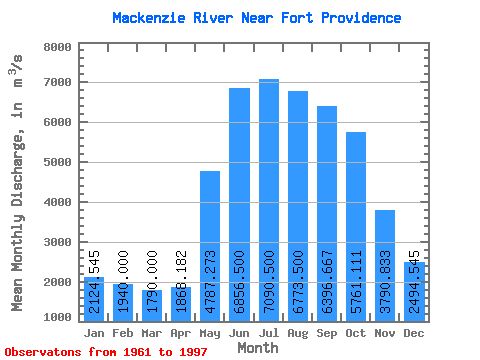
| Statistic | Jan | Feb | Mar | Apr | May | Jun | Jul | Aug | Sep | Oct | Nov | Dec | Annual |
|---|---|---|---|---|---|---|---|---|---|---|---|---|---|
| Mean | 2124.55 | 1940.00 | 1790.00 | 1868.18 | 4787.27 | 6856.50 | 7090.50 | 6773.50 | 6396.67 | 5761.11 | 3790.83 | 2494.55 | 4268.58 |
| Standard Deviation | 549.32 | 511.92 | 455.52 | 430.41 | 806.97 | 880.66 | 1161.20 | 1313.88 | 1277.59 | 1220.32 | 1109.33 | 500.75 | 718.99 |
| Min | 1280.00 | 1190.00 | 1270.00 | 1220.00 | 3900.00 | 4950.00 | 4550.00 | 4200.00 | 3990.00 | 3820.00 | 2260.00 | 1500.00 | 3502.50 |
| Max | 2840.00 | 2670.00 | 2560.00 | 2490.00 | 6180.00 | 8350.00 | 8610.00 | 8840.00 | 8420.00 | 7920.00 | 5990.00 | 3290.00 | 5420.83 |
| Coefficient of Variation | 0.26 | 0.26 | 0.25 | 0.23 | 0.17 | 0.13 | 0.16 | 0.19 | 0.20 | 0.21 | 0.29 | 0.20 | 0.17 |
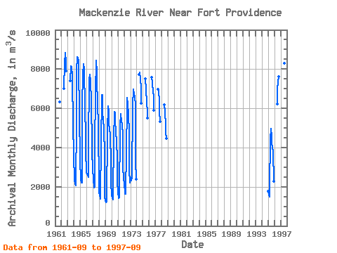
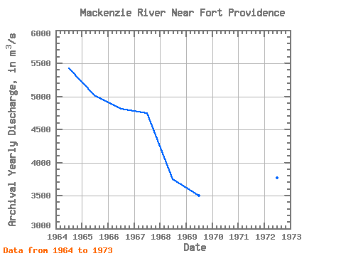
| Year | Jan | Feb | Mar | Apr | May | Jun | Jul | Aug | Sep | Oct | Nov | Dec | Annual | 1961 | 6330.00 | 1962 | 7000.00 | 8310.00 | 8840.00 | 8370.00 | 7920.00 | 1963 | 7400.00 | 8160.00 | 8110.00 | 7660.00 | 7120.00 | 5550.00 | 3290.00 | 1964 | 2680.00 | 2360.00 | 2140.00 | 2060.00 | 5380.00 | 7940.00 | 8610.00 | 8590.00 | 8420.00 | 7830.00 | 5990.00 | 3050.00 | 5420.83 | 1965 | 2620.00 | 2400.00 | 2190.00 | 2220.00 | 6180.00 | 7740.00 | 8260.00 | 8000.00 | 7270.00 | 6780.00 | 3820.00 | 2750.00 | 5019.17 | 1966 | 2710.00 | 2670.00 | 2560.00 | 2490.00 | 4190.00 | 7440.00 | 7730.00 | 7400.00 | 7160.00 | 6600.00 | 3740.00 | 2990.00 | 4806.67 | 1967 | 2840.00 | 2420.00 | 1970.00 | 2000.00 | 4040.00 | 6790.00 | 8430.00 | 7830.00 | 7080.00 | 6560.00 | 4790.00 | 2280.00 | 4752.50 | 1968 | 1690.00 | 1610.00 | 1370.00 | 1510.00 | 4150.00 | 6680.00 | 6700.00 | 5890.00 | 5270.00 | 5070.00 | 3510.00 | 1500.00 | 3745.83 | 1969 | 1280.00 | 1190.00 | 1270.00 | 1220.00 | 4840.00 | 6120.00 | 5870.00 | 5160.00 | 5010.00 | 4610.00 | 3280.00 | 2180.00 | 3502.50 | 1970 | 1610.00 | 1420.00 | 1360.00 | 1550.00 | 4380.00 | 5830.00 | 5770.00 | 5390.00 | 4800.00 | 4310.00 | 3420.00 | 2330.00 | 3514.17 | 1971 | 1680.00 | 1490.00 | 1400.00 | 1440.00 | 5080.00 | 5700.00 | 5560.00 | 5440.00 | 5110.00 | 4690.00 | 2920.00 | 2480.00 | 3582.50 | 1972 | 2050.00 | 1790.00 | 1620.00 | 1620.00 | 3900.00 | 6020.00 | 6530.00 | 6180.00 | 5680.00 | 4760.00 | 2900.00 | 2210.00 | 3771.67 | 1973 | 2450.00 | 2380.00 | 2310.00 | 2490.00 | 6100.00 | 6980.00 | 6980.00 | 6670.00 | 6630.00 | 6160.00 | 3310.00 | 2380.00 | 4570.00 | 1974 | 7730.00 | 7840.00 | 7510.00 | 7040.00 | 6270.00 | 1975 | 7500.00 | 6970.00 | 6290.00 | 5780.00 | 5510.00 | 1976 | 7590.00 | 7290.00 | 6840.00 | 6610.00 | 5880.00 | 1977 | 6960.00 | 6860.00 | 6400.00 | 5850.00 | 5330.00 | 1978 | 6190.00 | 5810.00 | 5090.00 | 4770.00 | 4480.00 | 1995 | 1760.00 | 1610.00 | 1500.00 | 1950.00 | 4420.00 | 4950.00 | 4550.00 | 4200.00 | 3990.00 | 3820.00 | 2260.00 | 1996 | 6220.00 | 6980.00 | 7360.00 | 7610.00 | 1997 | 8350.00 | 8600.00 | 8280.00 | 7890.00 |
|---|
 Return to R-Arctic Net Home Page