|
|
|||||||||||||||||
| Point ID: 3612 | Downloads | Plots | Site Data | Code: 10FA001 |
|
|
|||||||||||||||||
| Download | |
|---|---|
| Site Descriptor Information | Site Time Series Data |
| Link to all available data | |
|
|
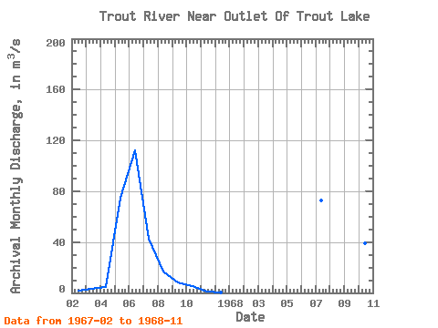
| View: | Statistics | Time Series |
| Units: | mm |
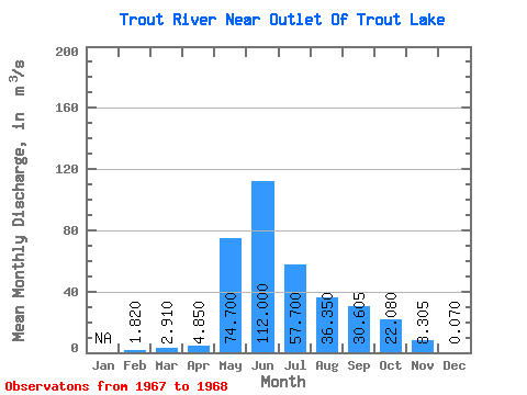
| Statistic | Jan | Feb | Mar | Apr | May | Jun | Jul | Aug | Sep | Oct | Nov | Dec | Annual |
|---|---|---|---|---|---|---|---|---|---|---|---|---|---|
| Mean | 1.82 | 2.91 | 4.85 | 74.70 | 112.00 | 57.70 | 36.35 | 30.61 | 22.08 | 8.30 | 0.07 | ||
| Standard Deviation | 21.64 | 27.51 | 31.53 | 23.65 | 10.18 | ||||||||
| Min | 1.82 | 2.91 | 4.85 | 74.70 | 112.00 | 42.40 | 16.90 | 8.31 | 5.36 | 1.11 | 0.07 | ||
| Max | 1.82 | 2.91 | 4.85 | 74.70 | 112.00 | 73.00 | 55.80 | 52.90 | 38.80 | 15.50 | 0.07 | ||
| Coefficient of Variation | 0.38 | 0.76 | 1.03 | 1.07 | 1.23 |
| Year | Jan | Feb | Mar | Apr | May | Jun | Jul | Aug | Sep | Oct | Nov | Dec | Annual | 1967 | 1.82 | 2.91 | 4.85 | 74.70 | 112.00 | 42.40 | 16.90 | 8.31 | 5.36 | 1.11 | 0.07 | 1968 | 73.00 | 55.80 | 52.90 | 38.80 | 15.50 |
|---|
 Return to R-Arctic Net Home Page