|
|
|||||||||||||||||
| Point ID: 3611 | Downloads | Plots | Site Data | Code: 10ED008 |
|
|
|||||||||||||||||
| Download | |
|---|---|
| Site Descriptor Information | Site Time Series Data |
| Link to all available data | |
|
|
| View: | Statistics | Time Series |
| Units: | mm |
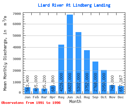
| Statistic | Jan | Feb | Mar | Apr | May | Jun | Jul | Aug | Sep | Oct | Nov | Dec | Annual |
|---|---|---|---|---|---|---|---|---|---|---|---|---|---|
| Mean | 563.40 | 465.00 | 435.20 | 681.80 | 4226.00 | 6822.00 | 5302.00 | 3752.00 | 2768.00 | 2050.00 | 748.00 | 657.17 | 2362.97 |
| Standard Deviation | 62.08 | 48.52 | 52.28 | 210.00 | 482.21 | 2323.26 | 1334.98 | 550.47 | 815.15 | 370.30 | 197.42 | 72.02 | 373.92 |
| Min | 491.00 | 397.00 | 385.00 | 420.00 | 3630.00 | 4060.00 | 3050.00 | 3150.00 | 2220.00 | 1530.00 | 517.00 | 542.00 | 1735.42 |
| Max | 654.00 | 529.00 | 522.00 | 994.00 | 4800.00 | 10500.00 | 6390.00 | 4400.00 | 4190.00 | 2510.00 | 1110.00 | 752.00 | 2731.33 |
| Coefficient of Variation | 0.11 | 0.10 | 0.12 | 0.31 | 0.11 | 0.34 | 0.25 | 0.15 | 0.29 | 0.18 | 0.26 | 0.11 | 0.16 |
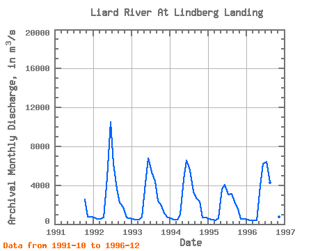
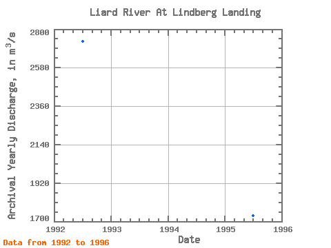
| Year | Jan | Feb | Mar | Apr | May | Jun | Jul | Aug | Sep | Oct | Nov | Dec | Annual | 1991 | 2510.00 | 768.00 | 752.00 | 1992 | 654.00 | 529.00 | 522.00 | 661.00 | 4800.00 | 10500.00 | 6210.00 | 3610.00 | 2220.00 | 1770.00 | 661.00 | 639.00 | 2731.33 | 1993 | 523.00 | 449.00 | 432.00 | 736.00 | 4220.00 | 6770.00 | 5340.00 | 4400.00 | 2420.00 | 1930.00 | 1110.00 | 710.00 | 2420.00 | 1994 | 581.00 | 486.00 | 431.00 | 994.00 | 4590.00 | 6560.00 | 5520.00 | 3350.00 | 2700.00 | 2330.00 | 701.00 | 665.00 | 2409.00 | 1995 | 568.00 | 464.00 | 406.00 | 598.00 | 3630.00 | 4060.00 | 3050.00 | 3150.00 | 2310.00 | 1530.00 | 517.00 | 542.00 | 1735.42 | 1996 | 491.00 | 397.00 | 385.00 | 420.00 | 3890.00 | 6220.00 | 6390.00 | 4250.00 | 4190.00 | 2230.00 | 731.00 | 635.00 | 2519.08 |
|---|
 Return to R-Arctic Net Home Page