|
|
|||||||||||||||||
| Point ID: 3602 | Downloads | Plots | Site Data | Code: 10EC001 |
|
|
|||||||||||||||||
| Download | |
|---|---|
| Site Descriptor Information | Site Time Series Data |
| Link to all available data | |
|
|
| View: | Statistics | Time Series |
| Units: | mm |
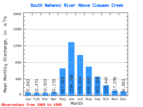
| Statistic | Jan | Feb | Mar | Apr | May | Jun | Jul | Aug | Sep | Oct | Nov | Dec | Annual |
|---|---|---|---|---|---|---|---|---|---|---|---|---|---|
| Mean | 75.84 | 63.47 | 59.91 | 85.18 | 657.83 | 1286.93 | 978.00 | 695.69 | 453.31 | 249.44 | 117.30 | 96.86 | 402.17 |
| Standard Deviation | 11.54 | 9.58 | 8.99 | 26.62 | 152.18 | 260.78 | 243.24 | 147.08 | 97.67 | 56.98 | 21.26 | 16.39 | 44.23 |
| Min | 52.60 | 46.10 | 45.40 | 52.20 | 368.00 | 855.00 | 640.00 | 454.00 | 309.00 | 185.00 | 78.00 | 68.70 | 334.18 |
| Max | 98.70 | 90.70 | 88.50 | 155.00 | 907.00 | 2120.00 | 1600.00 | 1130.00 | 716.00 | 362.00 | 171.00 | 135.00 | 504.57 |
| Coefficient of Variation | 0.15 | 0.15 | 0.15 | 0.31 | 0.23 | 0.20 | 0.25 | 0.21 | 0.21 | 0.23 | 0.18 | 0.17 | 0.11 |
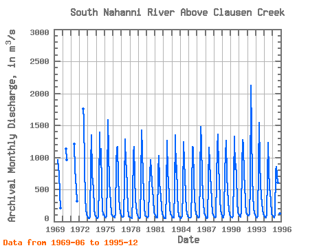
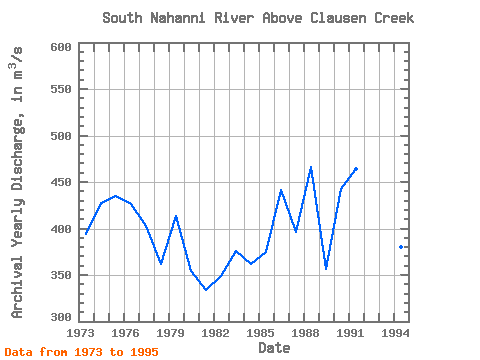
| Year | Jan | Feb | Mar | Apr | May | Jun | Jul | Aug | Sep | Oct | Nov | Dec | Annual | 1969 | 962.00 | 829.00 | 742.00 | 423.00 | 214.00 | 1970 | 1130.00 | 963.00 | 1971 | 1210.00 | 814.00 | 522.00 | 321.00 | 1972 | 1760.00 | 1600.00 | 851.00 | 358.00 | 195.00 | 103.00 | 77.80 | 1973 | 56.40 | 46.10 | 47.70 | 81.90 | 878.00 | 1350.00 | 748.00 | 593.00 | 540.00 | 192.00 | 115.00 | 82.80 | 394.24 | 1974 | 61.00 | 55.80 | 49.00 | 69.40 | 561.00 | 1390.00 | 883.00 | 1130.00 | 531.00 | 195.00 | 99.50 | 109.00 | 427.81 | 1975 | 81.00 | 68.00 | 59.70 | 83.30 | 651.00 | 1590.00 | 1090.00 | 626.00 | 446.00 | 305.00 | 123.00 | 96.20 | 434.93 | 1976 | 78.50 | 65.10 | 58.90 | 130.00 | 907.00 | 1160.00 | 1170.00 | 705.00 | 377.00 | 225.00 | 133.00 | 101.00 | 425.88 | 1977 | 82.40 | 66.80 | 66.70 | 83.00 | 612.00 | 1290.00 | 882.00 | 865.00 | 515.00 | 225.00 | 78.00 | 72.60 | 403.21 | 1978 | 71.50 | 63.80 | 57.30 | 52.80 | 368.00 | 1060.00 | 1170.00 | 697.00 | 336.00 | 239.00 | 136.00 | 92.30 | 361.98 | 1979 | 70.60 | 59.30 | 53.00 | 59.50 | 627.00 | 1430.00 | 1100.00 | 729.00 | 441.00 | 216.00 | 92.80 | 79.50 | 413.14 | 1980 | 76.80 | 68.10 | 63.10 | 93.60 | 506.00 | 960.00 | 804.00 | 604.00 | 469.00 | 362.00 | 135.00 | 110.00 | 354.30 | 1981 | 97.10 | 64.30 | 56.50 | 61.70 | 776.00 | 1030.00 | 640.00 | 454.00 | 414.00 | 207.00 | 110.00 | 99.50 | 334.18 | 1982 | 71.50 | 50.90 | 45.40 | 52.20 | 488.00 | 1260.00 | 763.00 | 641.00 | 396.00 | 207.00 | 110.00 | 98.80 | 348.65 | 1983 | 75.50 | 59.30 | 57.80 | 59.80 | 491.00 | 1350.00 | 768.00 | 871.00 | 429.00 | 196.00 | 85.00 | 71.40 | 376.15 | 1984 | 52.60 | 50.00 | 63.80 | 87.30 | 464.00 | 1240.00 | 925.00 | 698.00 | 416.00 | 192.00 | 85.80 | 68.70 | 361.93 | 1985 | 57.70 | 56.70 | 56.10 | 68.90 | 514.00 | 1170.00 | 1150.00 | 642.00 | 371.00 | 207.00 | 108.00 | 98.90 | 375.02 | 1986 | 81.90 | 61.00 | 57.20 | 68.70 | 690.00 | 1480.00 | 1220.00 | 678.00 | 427.00 | 281.00 | 139.00 | 107.00 | 440.90 | 1987 | 76.60 | 56.10 | 51.90 | 64.20 | 614.00 | 1160.00 | 932.00 | 683.00 | 558.00 | 318.00 | 136.00 | 99.30 | 395.76 | 1988 | 79.30 | 68.30 | 59.80 | 73.70 | 669.00 | 1160.00 | 1360.00 | 834.00 | 635.00 | 350.00 | 171.00 | 135.00 | 466.26 | 1989 | 75.70 | 63.50 | 58.20 | 123.00 | 803.00 | 1260.00 | 706.00 | 499.00 | 309.00 | 185.00 | 112.00 | 84.90 | 356.61 | 1990 | 71.30 | 64.70 | 64.10 | 84.50 | 695.00 | 1330.00 | 816.00 | 899.00 | 716.00 | 318.00 | 135.00 | 117.00 | 442.55 | 1991 | 88.60 | 79.40 | 74.10 | 155.00 | 866.00 | 1270.00 | 1200.00 | 716.00 | 575.00 | 292.00 | 134.00 | 118.00 | 464.01 | 1992 | 98.70 | 90.70 | 88.50 | 108.00 | 563.00 | 2120.00 | 1430.00 | 686.00 | 415.00 | 215.00 | 128.00 | 112.00 | 504.57 | 1993 | 76.50 | 64.20 | 63.30 | 80.80 | 884.00 | 1540.00 | 928.00 | 577.00 | 410.00 | 269.00 | 109.00 | 89.60 | 424.28 | 1994 | 76.90 | 64.20 | 63.60 | 118.00 | 707.00 | 1230.00 | 792.00 | 536.00 | 424.00 | 337.00 | 114.00 | 98.40 | 380.09 | 1995 | 86.30 | 73.50 | 62.20 | 99.80 | 796.00 | 855.00 | 723.00 | 610.00 | 534.00 | 294.00 | 123.00 | 105.00 | 363.48 |
|---|
 Return to R-Arctic Net Home Page