|
|
|||||||||||||||||
| Point ID: 3576 | Downloads | Plots | Site Data | Other Close Sites | Code: 07SA001 |
|
|
|||||||||||||||||
| Download | |
|---|---|
| Site Descriptor Information | Site Time Series Data |
| Link to all available data | |
|
|
| View: | Statistics | Time Series |
| Units: | mm |
| Statistic | Jan | Feb | Mar | Apr | May | Jun | Jul | Aug | Sep | Oct | Nov | Dec | Annual |
|---|---|---|---|---|---|---|---|---|---|---|---|---|---|
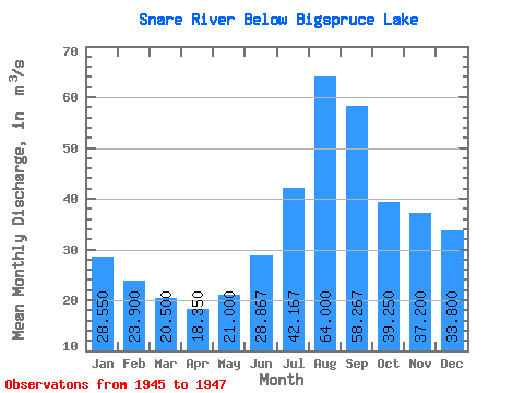
| Mean | 28.55 | 23.90 | 20.50 | 18.35 | 21.00 | 28.87 | 42.17 | 64.00 | 58.27 | 39.25 | 37.20 | 33.80 | 34.97 |
| Standard Deviation | 11.53 | 9.76 | 8.77 | 8.98 | 6.51 | 8.96 | 11.66 | 36.17 | 29.97 | 7.14 | 12.73 | 13.29 | |
| Min | 20.40 | 17.00 | 14.30 | 12.00 | 16.80 | 23.20 | 28.70 | 33.60 | 39.10 | 34.20 | 28.20 | 24.40 | 34.97 |
| Max | 36.70 | 30.80 | 26.70 | 24.70 | 28.50 | 39.20 | 48.90 | 104.00 | 92.80 | 44.30 | 46.20 | 43.20 | 34.97 |
| Coefficient of Variation | 0.40 | 0.41 | 0.43 | 0.49 | 0.31 | 0.31 | 0.28 | 0.56 | 0.51 | 0.18 | 0.34 | 0.39 |
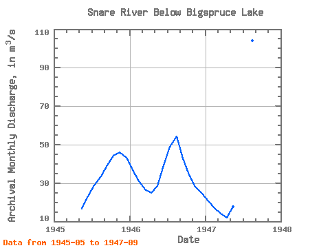
| Year | Jan | Feb | Mar | Apr | May | Jun | Jul | Aug | Sep | Oct | Nov | Dec | Annual | 1945 | 16.80 | 23.20 | 28.70 | 33.60 | 39.10 | 44.30 | 46.20 | 43.20 | 1946 | 36.70 | 30.80 | 26.70 | 24.70 | 28.50 | 39.20 | 48.90 | 54.40 | 42.90 | 34.20 | 28.20 | 24.40 | 34.97 | 1947 | 20.40 | 17.00 | 14.30 | 12.00 | 17.70 | 24.20 | 48.90 | 104.00 | 92.80 |
|---|
| Other Close Sites | ||||||
|---|---|---|---|---|---|---|
| PointID | Latitude | Longitude | Drainage Area | Source | Name | |
| 3578 | "SNARE RIVER AT BIGSPRUCE LAKE" | 63.51 | 1279822 | Hydat | ||
 Return to R-Arctic Net Home Page