|
|
|||||||||||||||||
| Point ID: 3559 | Downloads | Plots | Site Data | Code: 07NC008 |
|
|
|||||||||||||||||
| Download | |
|---|---|
| Site Descriptor Information | Site Time Series Data |
| Link to all available data | |
|
|
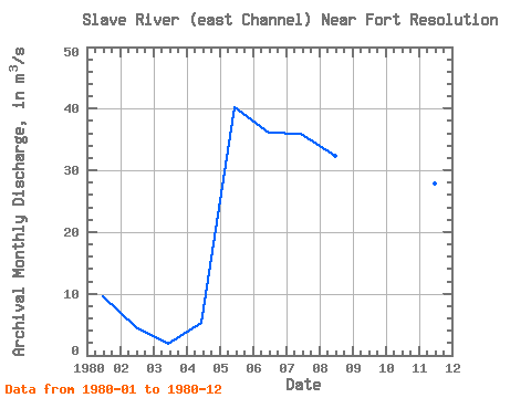
| View: | Statistics | Time Series |
| Units: | mm |
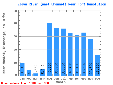
| Statistic | Jan | Feb | Mar | Apr | May | Jun | Jul | Aug | Sep | Oct | Nov | Dec | Annual |
|---|---|---|---|---|---|---|---|---|---|---|---|---|---|
| Mean | 9.61 | 4.50 | 1.95 | 5.24 | 40.30 | 36.20 | 35.90 | 32.40 | 31.10 | 32.90 | 27.90 | 15.90 | 22.82 |
| Standard Deviation | |||||||||||||
| Min | 9.61 | 4.50 | 1.95 | 5.24 | 40.30 | 36.20 | 35.90 | 32.40 | 31.10 | 32.90 | 27.90 | 15.90 | 22.82 |
| Max | 9.61 | 4.50 | 1.95 | 5.24 | 40.30 | 36.20 | 35.90 | 32.40 | 31.10 | 32.90 | 27.90 | 15.90 | 22.82 |
| Coefficient of Variation |
| Year | Jan | Feb | Mar | Apr | May | Jun | Jul | Aug | Sep | Oct | Nov | Dec | Annual | 1980 | 9.61 | 4.50 | 1.95 | 5.24 | 40.30 | 36.20 | 35.90 | 32.40 | 31.10 | 32.90 | 27.90 | 15.90 | 22.82 |
|---|
 Return to R-Arctic Net Home Page