|
|
|||||||||||||||||
| Point ID: 3555 | Downloads | Plots | Site Data | Code: 07NC003 |
|
|
|||||||||||||||||
| Download | |
|---|---|
| Site Descriptor Information | Site Time Series Data |
| Link to all available data | |
|
|
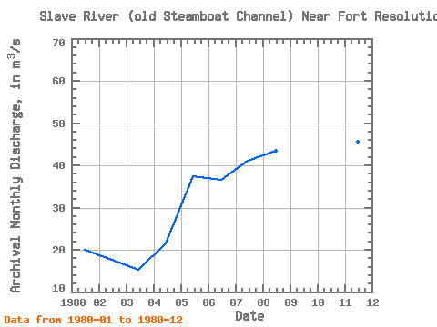
| View: | Statistics | Time Series |
| Units: | mm |
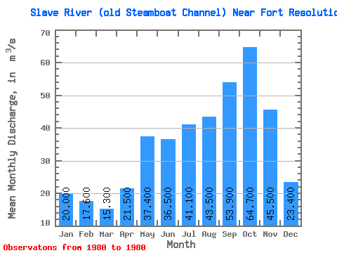
| Statistic | Jan | Feb | Mar | Apr | May | Jun | Jul | Aug | Sep | Oct | Nov | Dec | Annual |
|---|---|---|---|---|---|---|---|---|---|---|---|---|---|
| Mean | 20.00 | 17.60 | 15.30 | 21.50 | 37.40 | 36.50 | 41.10 | 43.50 | 53.90 | 64.70 | 45.50 | 23.40 | 35.03 |
| Standard Deviation | |||||||||||||
| Min | 20.00 | 17.60 | 15.30 | 21.50 | 37.40 | 36.50 | 41.10 | 43.50 | 53.90 | 64.70 | 45.50 | 23.40 | 35.03 |
| Max | 20.00 | 17.60 | 15.30 | 21.50 | 37.40 | 36.50 | 41.10 | 43.50 | 53.90 | 64.70 | 45.50 | 23.40 | 35.03 |
| Coefficient of Variation |
| Year | Jan | Feb | Mar | Apr | May | Jun | Jul | Aug | Sep | Oct | Nov | Dec | Annual | 1980 | 20.00 | 17.60 | 15.30 | 21.50 | 37.40 | 36.50 | 41.10 | 43.50 | 53.90 | 64.70 | 45.50 | 23.40 | 35.03 |
|---|
 Return to R-Arctic Net Home Page