|
|
|||||||||||||||||
| Point ID: 3550 | Downloads | Plots | Site Data | Code: 06OA005 |
|
|
|||||||||||||||||
| Download | |
|---|---|
| Site Descriptor Information | Site Time Series Data |
| Link to all available data | |
|
|
| View: | Statistics | Time Series |
| Units: | mm |
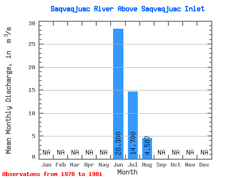
| Statistic | Jan | Feb | Mar | Apr | May | Jun | Jul | Aug | Sep | Oct | Nov | Dec | Annual |
|---|---|---|---|---|---|---|---|---|---|---|---|---|---|
| Mean | 28.30 | 14.70 | 4.59 | ||||||||||
| Standard Deviation | 2.97 | 3.28 | |||||||||||
| Min | 28.30 | 12.60 | 2.06 | ||||||||||
| Max | 28.30 | 16.80 | 8.29 | ||||||||||
| Coefficient of Variation | 0.20 | 0.71 |
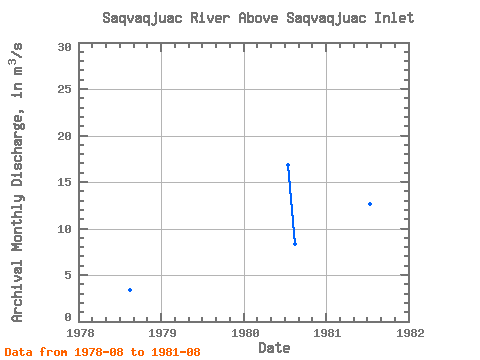
| Year | Jan | Feb | Mar | Apr | May | Jun | Jul | Aug | Sep | Oct | Nov | Dec | Annual | 1978 | 3.41 | 1980 | 16.80 | 8.29 | 1981 | 28.30 | 12.60 | 2.06 |
|---|
 Return to R-Arctic Net Home Page