|
|
|||||||||||||||||
| Point ID: 3541 | Downloads | Plots | Site Data | Code: 06MA006 |
|
|
|||||||||||||||||
| Download | |
|---|---|
| Site Descriptor Information | Site Time Series Data |
| Link to all available data | |
|
|
| View: | Statistics | Time Series |
| Units: | mm |
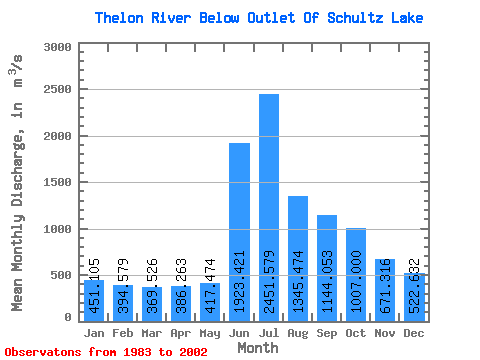
| Statistic | Jan | Feb | Mar | Apr | May | Jun | Jul | Aug | Sep | Oct | Nov | Dec | Annual |
|---|---|---|---|---|---|---|---|---|---|---|---|---|---|
| Mean | 451.11 | 394.58 | 369.53 | 386.26 | 417.47 | 1923.42 | 2451.58 | 1345.47 | 1144.05 | 1007.00 | 671.32 | 522.63 | 923.70 |
| Standard Deviation | 87.77 | 85.17 | 83.14 | 80.99 | 79.89 | 676.18 | 608.50 | 277.06 | 230.37 | 187.66 | 80.16 | 101.53 | 139.61 |
| Min | 276.00 | 228.00 | 226.00 | 232.00 | 238.00 | 965.00 | 1480.00 | 829.00 | 749.00 | 626.00 | 522.00 | 386.00 | 668.67 |
| Max | 619.00 | 536.00 | 529.00 | 543.00 | 546.00 | 3470.00 | 3440.00 | 1820.00 | 1450.00 | 1270.00 | 829.00 | 726.00 | 1195.08 |
| Coefficient of Variation | 0.20 | 0.22 | 0.23 | 0.21 | 0.19 | 0.35 | 0.25 | 0.21 | 0.20 | 0.19 | 0.12 | 0.19 | 0.15 |
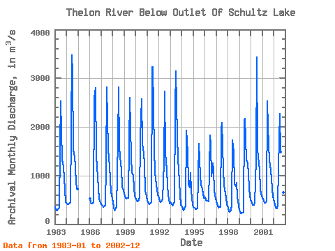
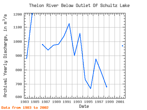
| Year | Jan | Feb | Mar | Apr | May | Jun | Jul | Aug | Sep | Oct | Nov | Dec | Annual | 1983 | 345.00 | 285.00 | 282.00 | 304.00 | 339.00 | 1570.00 | 2530.00 | 1310.00 | 1250.00 | 1170.00 | 704.00 | 455.00 | 878.67 | 1984 | 418.00 | 405.00 | 406.00 | 423.00 | 464.00 | 3470.00 | 3110.00 | 1520.00 | 1390.00 | 1180.00 | 829.00 | 726.00 | 1195.08 | 1986 | 521.00 | 439.00 | 419.00 | 418.00 | 472.00 | 2600.00 | 2800.00 | 1400.00 | 965.00 | 732.00 | 522.00 | 431.00 | 976.58 | 1987 | 413.00 | 381.00 | 351.00 | 360.00 | 384.00 | 1220.00 | 2820.00 | 1540.00 | 1350.00 | 1190.00 | 656.00 | 593.00 | 938.17 | 1988 | 449.00 | 330.00 | 275.00 | 318.00 | 346.00 | 1720.00 | 2820.00 | 1570.00 | 1230.00 | 1150.00 | 773.00 | 701.00 | 973.50 | 1989 | 619.00 | 536.00 | 529.00 | 543.00 | 535.00 | 1660.00 | 2600.00 | 1380.00 | 1050.00 | 994.00 | 737.00 | 564.00 | 978.92 | 1990 | 525.00 | 474.00 | 460.00 | 489.00 | 546.00 | 1790.00 | 2580.00 | 1650.00 | 1450.00 | 1220.00 | 683.00 | 574.00 | 1036.75 | 1991 | 486.00 | 419.00 | 415.00 | 426.00 | 450.00 | 3240.00 | 3230.00 | 1520.00 | 1070.00 | 922.00 | 712.00 | 612.00 | 1125.17 | 1992 | 535.00 | 472.00 | 445.00 | 475.00 | 520.00 | 1260.00 | 2730.00 | 1450.00 | 1110.00 | 798.00 | 597.00 | 419.00 | 900.92 | 1993 | 453.00 | 420.00 | 378.00 | 395.00 | 448.00 | 2400.00 | 3150.00 | 1820.00 | 1340.00 | 891.00 | 591.00 | 394.00 | 1056.67 | 1994 | 365.00 | 302.00 | 285.00 | 344.00 | 376.00 | 1930.00 | 1480.00 | 829.00 | 749.00 | 1050.00 | 678.00 | 398.00 | 732.17 | 1995 | 354.00 | 343.00 | 315.00 | 309.00 | 320.00 | 965.00 | 1660.00 | 1000.00 | 794.00 | 776.00 | 644.00 | 544.00 | 668.67 | 1996 | 555.00 | 501.00 | 474.00 | 487.00 | 460.00 | 1830.00 | 1630.00 | 984.00 | 1260.00 | 1130.00 | 685.00 | 518.00 | 876.17 | 1997 | 459.00 | 386.00 | 344.00 | 369.00 | 351.00 | 1950.00 | 2090.00 | 1110.00 | 794.00 | 626.00 | 541.00 | 404.00 | 785.33 | 1998 | 343.00 | 259.00 | 249.00 | 284.00 | 406.00 | 1730.00 | 1480.00 | 831.00 | 775.00 | 856.00 | 566.00 | 386.00 | 680.42 | 1999 | 276.00 | 228.00 | 226.00 | 232.00 | 238.00 | 2130.00 | 2170.00 | 1320.00 | 1290.00 | 1270.00 | 746.00 | 569.00 | 891.25 | 2000 | 461.00 | 443.00 | 394.00 | 396.00 | 430.00 | 1360.00 | 3440.00 | 1540.00 | 1240.00 | 1130.00 | 716.00 | 566.00 | 1009.67 | 2001 | 540.00 | 481.00 | 433.00 | 440.00 | 471.00 | 2530.00 | 1990.00 | 1300.00 | 1230.00 | 938.00 | 716.00 | 566.00 | 969.58 | 2002 | 454.00 | 393.00 | 341.00 | 327.00 | 376.00 | 1190.00 | 2270.00 | 1490.00 | 1400.00 | 1110.00 | 659.00 | 510.00 | 876.67 |
|---|
 Return to R-Arctic Net Home Page