|
|
|||||||||||||||||
| Point ID: 3533 | Downloads | Plots | Site Data | Code: 06LA001 |
|
|
|||||||||||||||||
| Download | |
|---|---|
| Site Descriptor Information | Site Time Series Data |
| Link to all available data | |
|
|
| View: | Statistics | Time Series |
| Units: | mm |
| Statistic | Jan | Feb | Mar | Apr | May | Jun | Jul | Aug | Sep | Oct | Nov | Dec | Annual |
|---|---|---|---|---|---|---|---|---|---|---|---|---|---|
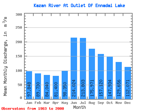
| Mean | 97.85 | 89.73 | 84.04 | 81.40 | 98.35 | 214.02 | 213.80 | 175.97 | 157.12 | 147.93 | 129.66 | 112.07 | 134.16 |
| Standard Deviation | 28.44 | 27.46 | 26.45 | 22.03 | 23.17 | 64.06 | 64.38 | 46.09 | 49.09 | 58.90 | 48.18 | 35.79 | 31.96 |
| Min | 49.30 | 45.90 | 46.40 | 47.60 | 55.10 | 92.80 | 91.60 | 88.00 | 66.30 | 59.70 | 56.30 | 52.90 | 75.71 |
| Max | 177.00 | 162.00 | 150.00 | 131.00 | 141.00 | 335.00 | 373.00 | 300.00 | 303.00 | 376.00 | 297.00 | 211.00 | 223.25 |
| Coefficient of Variation | 0.29 | 0.31 | 0.32 | 0.27 | 0.24 | 0.30 | 0.30 | 0.26 | 0.31 | 0.40 | 0.37 | 0.32 | 0.24 |
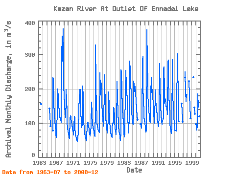
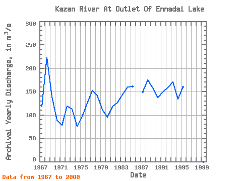
| Year | Jan | Feb | Mar | Apr | May | Jun | Jul | Aug | Sep | Oct | Nov | Dec | Annual | 1963 | 159.00 | 156.00 | 1965 | 142.00 | 115.00 | 101.00 | 90.80 | 1966 | 77.60 | 233.00 | 228.00 | 159.00 | 129.00 | 118.00 | 107.00 | 90.00 | 1967 | 77.30 | 66.50 | 57.90 | 63.90 | 70.90 | 147.00 | 200.00 | 173.00 | 154.00 | 153.00 | 134.00 | 121.00 | 118.21 | 1968 | 117.00 | 115.00 | 115.00 | 113.00 | 102.00 | 296.00 | 355.00 | 300.00 | 282.00 | 376.00 | 297.00 | 211.00 | 223.25 | 1969 | 177.00 | 162.00 | 146.00 | 131.00 | 117.00 | 169.00 | 199.00 | 167.00 | 133.00 | 104.00 | 85.80 | 75.10 | 138.82 | 1970 | 71.60 | 67.50 | 60.00 | 55.70 | 55.10 | 112.00 | 121.00 | 120.00 | 113.00 | 106.00 | 94.80 | 84.40 | 88.42 | 1971 | 79.40 | 76.90 | 70.40 | 64.70 | 88.10 | 120.00 | 114.00 | 88.00 | 66.30 | 59.70 | 56.30 | 52.90 | 78.06 | 1972 | 49.30 | 45.90 | 46.40 | 59.10 | 69.30 | 150.00 | 149.00 | 167.00 | 199.00 | 198.00 | 162.00 | 131.00 | 118.83 | 1973 | 107.00 | 91.00 | 86.90 | 96.00 | 134.00 | 208.00 | 174.00 | 134.00 | 102.00 | 86.50 | 69.60 | 61.90 | 112.58 | 1974 | 62.30 | 55.40 | 49.80 | 47.60 | 58.20 | 92.80 | 91.60 | 102.00 | 100.00 | 89.70 | 82.80 | 76.30 | 75.71 | 1975 | 67.90 | 61.70 | 64.80 | 68.20 | 96.10 | 158.00 | 161.00 | 127.00 | 95.90 | 86.10 | 87.10 | 81.00 | 96.23 | 1976 | 76.50 | 70.90 | 65.50 | 60.40 | 141.00 | 329.00 | 216.00 | 148.00 | 122.00 | 99.70 | 91.60 | 84.20 | 125.40 | 1977 | 80.90 | 79.10 | 74.70 | 72.40 | 111.00 | 247.00 | 205.00 | 183.00 | 213.00 | 217.00 | 186.00 | 157.00 | 152.18 | 1978 | 128.00 | 110.00 | 97.50 | 91.00 | 106.00 | 201.00 | 241.00 | 206.00 | 164.00 | 133.00 | 115.00 | 99.40 | 140.99 | 1979 | 83.90 | 74.20 | 70.30 | 82.00 | 113.00 | 192.00 | 189.00 | 142.00 | 116.00 | 101.00 | 88.30 | 77.60 | 110.78 | 1980 | 70.60 | 65.70 | 60.70 | 58.30 | 83.50 | 98.00 | 97.90 | 105.00 | 145.00 | 141.00 | 119.00 | 101.00 | 95.47 | 1981 | 87.00 | 77.10 | 70.10 | 67.30 | 93.60 | 220.00 | 222.00 | 177.00 | 127.00 | 104.00 | 87.90 | 77.10 | 117.51 | 1982 | 68.60 | 61.70 | 55.70 | 49.90 | 72.10 | 256.00 | 251.00 | 192.00 | 152.00 | 137.00 | 122.00 | 103.00 | 126.75 | 1983 | 85.00 | 71.20 | 58.90 | 72.80 | 82.40 | 194.00 | 254.00 | 215.00 | 189.00 | 188.00 | 171.00 | 136.00 | 143.11 | 1984 | 112.00 | 88.90 | 74.10 | 70.70 | 124.00 | 282.00 | 253.00 | 211.00 | 206.00 | 195.00 | 166.00 | 134.00 | 159.72 | 1985 | 113.00 | 106.00 | 99.70 | 95.00 | 129.00 | 223.00 | 208.00 | 193.00 | 201.00 | 207.00 | 188.00 | 164.00 | 160.56 | 1986 | 144.00 | 137.00 | 123.00 | 110.00 | 1987 | 96.80 | 90.90 | 86.30 | 84.80 | 114.00 | 288.00 | 295.00 | 208.00 | 163.00 | 134.00 | 117.00 | 109.00 | 148.90 | 1988 | 100.00 | 88.70 | 79.70 | 74.20 | 76.50 | 335.00 | 373.00 | 281.00 | 211.00 | 181.00 | 159.00 | 137.00 | 174.68 | 1989 | 121.00 | 112.00 | 105.00 | 102.00 | 107.00 | 184.00 | 235.00 | 195.00 | 190.00 | 199.00 | 179.00 | 155.00 | 157.00 | 1990 | 138.00 | 124.00 | 111.00 | 100.00 | 104.00 | 197.00 | 182.00 | 165.00 | 148.00 | 134.00 | 125.00 | 114.00 | 136.83 | 1991 | 105.00 | 97.70 | 92.20 | 89.30 | 122.00 | 274.00 | 261.00 | 202.00 | 164.00 | 148.00 | 124.00 | 107.00 | 148.85 | 1992 | 94.80 | 97.80 | 107.00 | 109.00 | 115.00 | 260.00 | 264.00 | 199.00 | 159.00 | 171.00 | 167.00 | 156.00 | 158.30 | 1993 | 149.00 | 148.00 | 150.00 | 126.00 | 130.00 | 279.00 | 284.00 | 223.00 | 181.00 | 151.00 | 123.00 | 99.20 | 170.27 | 1994 | 82.10 | 79.70 | 76.50 | 69.10 | 90.10 | 286.00 | 250.00 | 184.00 | 144.00 | 131.00 | 120.00 | 98.10 | 134.22 | 1995 | 85.50 | 78.20 | 78.60 | 78.60 | 76.00 | 163.00 | 204.00 | 231.00 | 303.00 | 249.00 | 197.00 | 168.00 | 159.32 | 1996 | 106.00 | 157.00 | 135.00 | 117.00 | 104.00 | 1997 | 233.00 | 250.00 | 193.00 | 163.00 | 183.00 | 1998 | 223.00 | 183.00 | 146.00 | 120.00 | 114.00 | 1999 | 235.00 | 146.00 | 127.00 | 2000 | 96.80 | 91.20 | 87.50 | 80.00 | 92.00 | 178.00 | 186.00 | 149.00 | 126.00 | 120.00 | 119.00 | 109.00 | 119.54 |
|---|
 Return to R-Arctic Net Home Page