|
|
|||||||||||||||||
| Point ID: 3528 | Downloads | Plots | Site Data | Code: 06HE001 |
|
|
|||||||||||||||||
| Download | |
|---|---|
| Site Descriptor Information | Site Time Series Data |
| Link to all available data | |
|
|
| View: | Statistics | Time Series |
| Units: | mm |
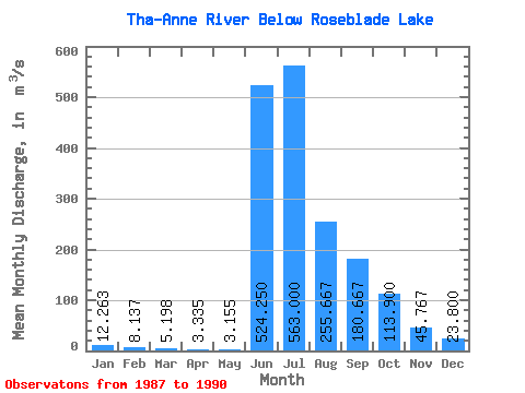
| Statistic | Jan | Feb | Mar | Apr | May | Jun | Jul | Aug | Sep | Oct | Nov | Dec | Annual |
|---|---|---|---|---|---|---|---|---|---|---|---|---|---|
| Mean | 12.26 | 8.14 | 5.20 | 3.33 | 3.15 | 524.25 | 563.00 | 255.67 | 180.67 | 113.90 | 45.77 | 23.80 | 142.07 |
| Standard Deviation | 7.20 | 3.63 | 1.08 | 1.10 | 1.54 | 193.69 | 205.26 | 13.28 | 54.15 | 46.86 | 20.26 | 10.82 | 37.70 |
| Min | 4.00 | 3.75 | 3.59 | 1.78 | 0.88 | 274.00 | 331.00 | 248.00 | 129.00 | 85.90 | 24.20 | 11.40 | 98.98 |
| Max | 20.70 | 12.50 | 5.88 | 4.36 | 4.14 | 708.00 | 721.00 | 271.00 | 237.00 | 168.00 | 64.40 | 31.30 | 168.99 |
| Coefficient of Variation | 0.59 | 0.45 | 0.21 | 0.33 | 0.49 | 0.37 | 0.36 | 0.05 | 0.30 | 0.41 | 0.44 | 0.46 | 0.27 |
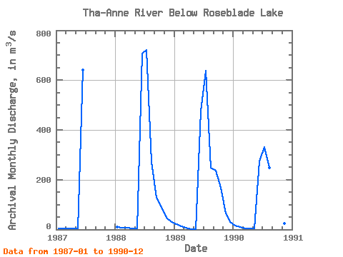
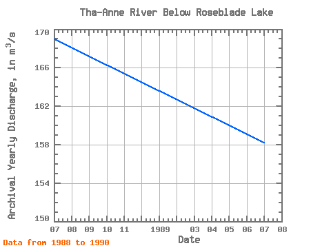
| Year | Jan | Feb | Mar | Apr | May | Jun | Jul | Aug | Sep | Oct | Nov | Dec | Annual | 1987 | 4.00 | 3.75 | 3.59 | 3.50 | 3.52 | 641.00 | 1988 | 9.35 | 7.35 | 5.88 | 4.36 | 4.14 | 708.00 | 721.00 | 271.00 | 129.00 | 87.80 | 48.70 | 31.30 | 168.99 | 1989 | 20.70 | 12.50 | 5.77 | 1.78 | 0.88 | 474.00 | 637.00 | 248.00 | 237.00 | 168.00 | 64.40 | 28.70 | 158.23 | 1990 | 15.00 | 8.95 | 5.55 | 3.70 | 4.08 | 274.00 | 331.00 | 248.00 | 176.00 | 85.90 | 24.20 | 11.40 | 98.98 |
|---|
 Return to R-Arctic Net Home Page