|
|
|||||||||||||||||
| Point ID: 351 | Downloads | Plots | Site Data | Other Close Sites | Code: 05BN012 |
|
|
|||||||||||||||||
| Download | |
|---|---|
| Site Descriptor Information | Site Time Series Data |
| Link to all available data | |
|
|
| View: | Statistics | Time Series |
| Units: | mm |
| Statistic | Jan | Feb | Mar | Apr | May | Jun | Jul | Aug | Sep | Oct | Nov | Dec | Annual |
|---|---|---|---|---|---|---|---|---|---|---|---|---|---|
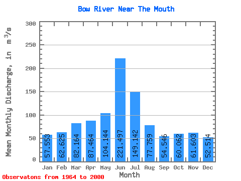
| Mean | 57.55 | 62.62 | 82.16 | 87.46 | 104.14 | 221.50 | 149.14 | 77.76 | 54.55 | 60.06 | 61.60 | 52.51 | 89.38 |
| Standard Deviation | 9.51 | 10.22 | 20.80 | 41.67 | 56.48 | 122.40 | 96.89 | 47.06 | 33.17 | 29.05 | 14.70 | 13.88 | 28.63 |
| Min | 38.20 | 38.30 | 51.40 | 11.70 | 16.20 | 35.20 | 26.60 | 25.60 | 16.90 | 10.30 | 26.10 | 25.70 | 43.93 |
| Max | 77.40 | 82.90 | 134.00 | 185.00 | 232.00 | 591.00 | 387.00 | 190.00 | 166.00 | 135.00 | 103.00 | 88.40 | 145.73 |
| Coefficient of Variation | 0.17 | 0.16 | 0.25 | 0.48 | 0.54 | 0.55 | 0.65 | 0.60 | 0.61 | 0.48 | 0.24 | 0.26 | 0.32 |
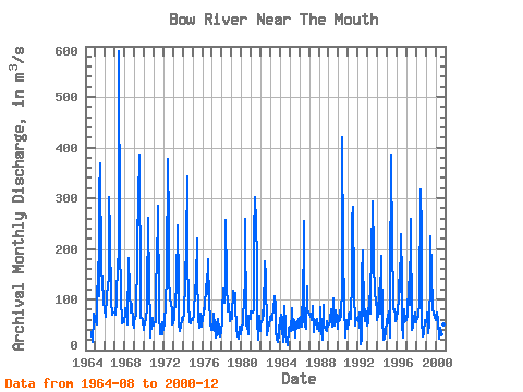
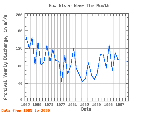
| Year | Jan | Feb | Mar | Apr | May | Jun | Jul | Aug | Sep | Oct | Nov | Dec | Annual | 1964 | 35.50 | 16.90 | 63.40 | 72.40 | 64.70 | 1965 | 55.60 | 50.70 | 80.80 | 173.00 | 107.00 | 309.00 | 369.00 | 158.00 | 133.00 | 135.00 | 103.00 | 74.70 | 145.73 | 1966 | 76.70 | 66.60 | 110.00 | 123.00 | 145.00 | 302.00 | 229.00 | 96.70 | 72.20 | 70.40 | 75.10 | 74.80 | 120.12 | 1967 | 70.50 | 70.40 | 96.80 | 175.00 | 185.00 | 591.00 | 223.00 | 96.60 | 62.60 | 51.80 | 54.20 | 54.60 | 144.29 | 1968 | 72.90 | 82.90 | 78.80 | 61.70 | 50.30 | 181.00 | 117.00 | 73.40 | 83.50 | 92.30 | 54.40 | 44.50 | 82.72 | 1969 | 61.80 | 60.90 | 72.60 | 185.00 | 217.00 | 298.00 | 387.00 | 105.00 | 63.50 | 63.10 | 60.20 | 39.40 | 134.46 | 1970 | 45.70 | 53.60 | 62.70 | 83.60 | 106.00 | 261.00 | 126.00 | 55.00 | 25.80 | 57.00 | 62.80 | 47.50 | 82.22 | 1971 | 51.50 | 55.50 | 54.90 | 144.00 | 157.00 | 284.00 | 93.40 | 71.80 | 30.90 | 39.70 | 55.00 | 30.50 | 89.02 | 1972 | 45.60 | 48.50 | 96.50 | 89.70 | 151.00 | 378.00 | 248.00 | 143.00 | 100.00 | 90.40 | 80.20 | 51.00 | 126.83 | 1973 | 53.60 | 64.40 | 103.00 | 89.70 | 132.00 | 247.00 | 131.00 | 49.70 | 37.20 | 46.50 | 59.30 | 63.10 | 89.71 | 1974 | 59.80 | 73.20 | 71.10 | 138.00 | 208.00 | 344.00 | 184.00 | 96.30 | 55.80 | 51.90 | 61.60 | 62.30 | 117.17 | 1975 | 59.20 | 66.70 | 68.40 | 124.00 | 134.00 | 221.00 | 155.00 | 60.70 | 45.10 | 54.50 | 72.80 | 46.00 | 92.28 | 1976 | 63.40 | 74.80 | 82.40 | 80.90 | 131.00 | 111.00 | 122.00 | 179.00 | 95.10 | 56.50 | 52.90 | 40.70 | 90.81 | 1977 | 39.10 | 60.60 | 72.30 | 49.30 | 24.10 | 55.60 | 28.50 | 60.50 | 42.70 | 33.00 | 26.10 | 37.60 | 44.12 | 1978 | 56.90 | 73.60 | 122.00 | 94.10 | 126.00 | 257.00 | 136.00 | 76.70 | 90.60 | 90.60 | 57.20 | 66.20 | 103.91 | 1979 | 60.30 | 67.00 | 118.00 | 98.60 | 112.00 | 91.90 | 41.10 | 28.80 | 21.80 | 26.00 | 46.50 | 30.80 | 61.90 | 1980 | 43.90 | 46.00 | 51.40 | 111.00 | 127.00 | 260.00 | 49.30 | 48.70 | 31.30 | 66.70 | 61.60 | 60.60 | 79.79 | 1981 | 77.40 | 74.00 | 74.90 | 79.40 | 232.00 | 302.00 | 252.00 | 177.00 | 60.00 | 20.00 | 66.70 | 37.10 | 121.04 | 1982 | 48.80 | 56.70 | 60.20 | 98.20 | 66.90 | 176.00 | 146.00 | 35.80 | 29.30 | 43.80 | 51.00 | 60.10 | 72.73 | 1983 | 64.80 | 68.00 | 60.00 | 85.00 | 78.40 | 107.00 | 84.10 | 36.90 | 23.00 | 15.50 | 48.80 | 25.70 | 58.10 | 1984 | 57.10 | 70.20 | 61.40 | 43.20 | 16.20 | 86.70 | 50.60 | 31.30 | 18.20 | 10.30 | 39.50 | 42.50 | 43.93 | 1985 | 46.60 | 38.30 | 77.90 | 83.30 | 39.40 | 58.60 | 26.60 | 25.60 | 55.70 | 56.30 | 43.70 | 59.10 | 50.92 | 1986 | 63.00 | 46.00 | 85.30 | 46.70 | 62.20 | 255.00 | 117.00 | 45.20 | 42.20 | 125.00 | 80.20 | 75.20 | 86.92 | 1987 | 70.90 | 68.30 | 68.30 | 58.50 | 86.80 | 35.50 | 56.00 | 50.40 | 59.50 | 41.50 | 61.20 | 43.30 | 58.35 | 1988 | 38.20 | 44.30 | 84.90 | 38.80 | 20.00 | 89.40 | 48.20 | 46.50 | 40.30 | 38.50 | 57.40 | 45.70 | 49.35 | 1989 | 50.10 | 55.90 | 60.40 | 79.60 | 45.60 | 103.00 | 48.80 | 47.80 | 75.30 | 78.70 | 63.50 | 42.40 | 62.59 | 1990 | 67.30 | 58.70 | 77.50 | 66.00 | 125.00 | 421.00 | 192.00 | 89.30 | 24.30 | 57.80 | 59.80 | 41.60 | 106.69 | 1991 | 54.40 | 69.80 | 74.60 | 61.50 | 143.00 | 257.00 | 282.00 | 119.00 | 49.20 | 53.20 | 62.80 | 58.60 | 107.09 | 1992 | 57.60 | 56.70 | 75.00 | 11.70 | 20.10 | 147.00 | 197.00 | 74.10 | 57.00 | 81.60 | 74.70 | 48.50 | 75.08 | 1993 | 52.60 | 59.70 | 106.00 | 72.50 | 112.00 | 187.00 | 293.00 | 190.00 | 166.00 | 119.00 | 89.60 | 88.40 | 127.98 | 1994 | 58.80 | 68.80 | 122.00 | 72.00 | 101.00 | 186.00 | 54.50 | 29.20 | 19.70 | 22.10 | 38.00 | 56.80 | 69.08 | 1995 | 58.30 | 66.10 | 76.00 | 25.40 | 119.00 | 387.00 | 199.00 | 108.00 | 79.60 | 79.80 | 69.70 | 56.20 | 110.34 | 1996 | 63.00 | 77.40 | 104.00 | 138.00 | 115.00 | 229.00 | 138.00 | 52.10 | 24.10 | 80.30 | 56.50 | 58.00 | 94.62 | 1997 | 58.70 | 68.60 | 134.00 | 103.00 | 88.60 | 259.00 | 42.00 | 40.00 | 44.00 | 62.50 | 73.50 | 58.80 | 86.06 | 1998 | 54.20 | 65.60 | 65.20 | 72.30 | 91.70 | 317.00 | 234.00 | 58.10 | 27.80 | 33.80 | 59.70 | 51.40 | 94.23 | 1999 | 55.20 | 58.90 | 73.50 | 33.10 | 51.50 | 144.00 | 224.00 | 154.00 | 84.10 | 70.20 | 76.20 | 63.20 | 90.66 | 2000 | 58.40 | 67.10 | 75.10 | 59.90 | 22.40 | 35.20 | 45.00 | 31.40 | 30.90 | 43.60 | 51.50 | 41.40 | 46.83 |
|---|
| Other Close Sites | ||||||
|---|---|---|---|---|---|---|
| PointID | Latitude | Longitude | Drainage Area | Source | Name | |
| 177 | "OLDMAN RIVER NEAR THE MOUTH" | 49.91 | 1621979 | Hydat | ||
 Return to R-Arctic Net Home Page