|
|
|||||||||||||||||
| Point ID: 337 | Downloads | Plots | Site Data | Code: 05BM016 |
|
|
|||||||||||||||||
| Download | |
|---|---|
| Site Descriptor Information | Site Time Series Data |
| Link to all available data | |
|
|
| View: | Statistics | Time Series |
| Units: | mm |
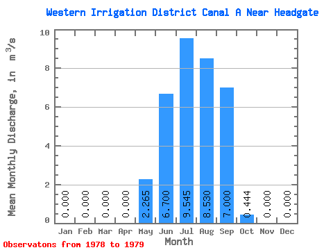
| Statistic | Jan | Feb | Mar | Apr | May | Jun | Jul | Aug | Sep | Oct | Nov | Dec | Annual |
|---|---|---|---|---|---|---|---|---|---|---|---|---|---|
| Mean | 0.00 | 0.00 | 0.00 | 0.00 | 2.27 | 6.70 | 9.54 | 8.53 | 7.00 | 0.44 | 0.00 | 0.00 | 2.87 |
| Standard Deviation | 0.00 | 0.00 | 0.00 | 0.00 | 0.70 | 3.39 | 3.47 | 1.26 | 0.40 | 0.22 | 0.00 | 0.00 | 0.63 |
| Min | 0.00 | 0.00 | 0.00 | 0.00 | 1.77 | 4.30 | 7.09 | 7.64 | 6.72 | 0.29 | 0.00 | 0.00 | 2.43 |
| Max | 0.00 | 0.00 | 0.00 | 0.00 | 2.76 | 9.10 | 12.00 | 9.42 | 7.28 | 0.60 | 0.00 | 0.00 | 3.32 |
| Coefficient of Variation | 0.31 | 0.51 | 0.36 | 0.15 | 0.06 | 0.50 | 0.22 |
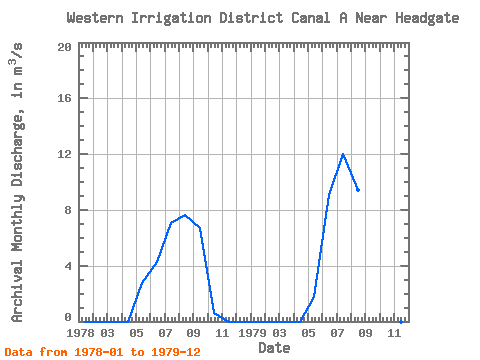
| Year | Jan | Feb | Mar | Apr | May | Jun | Jul | Aug | Sep | Oct | Nov | Dec | Annual | 1978 | 0.00 | 0.00 | 0.00 | 0.00 | 2.76 | 4.30 | 7.09 | 7.64 | 6.72 | 0.60 | 0.00 | 0.00 | 2.43 | 1979 | 0.00 | 0.00 | 0.00 | 0.00 | 1.77 | 9.10 | 12.00 | 9.42 | 7.28 | 0.29 | 0.00 | 0.00 | 3.32 |
|---|
 Return to R-Arctic Net Home Page