|
|
|||||||||||||||||
| Point ID: 33 | Downloads | Plots | Site Data | Code: 05AB015 |
|
|
|||||||||||||||||
| Download | |
|---|---|
| Site Descriptor Information | Site Time Series Data |
| Link to all available data | |
| View: | Time Series | All |
| Units: | m3/s |
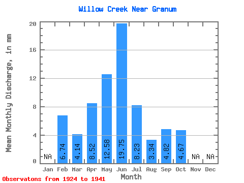
| Statistic | Jan | Feb | Mar | Apr | May | Jun | Jul | Aug | Sep | Oct | Nov | Dec | Annual |
|---|---|---|---|---|---|---|---|---|---|---|---|---|---|
| Mean | 6.26 | 3.81 | 7.84 | 11.58 | 18.17 | 7.58 | 3.07 | 4.44 | 4.30 | ||||
| Standard Deviation | 3.43 | 4.42 | 11.84 | 17.22 | 10.50 | 4.22 | 7.75 | 6.33 | |||||
| Min | 6.26 | 0.45 | 1.88 | 1.90 | 1.74 | 0.14 | 0.00 | 0.00 | 0.00 | ||||
| Max | 6.26 | 14.19 | 16.46 | 43.25 | 60.01 | 40.57 | 12.32 | 25.14 | 22.63 | ||||
| Coefficient of Variation | 0.90 | 0.56 | 1.02 | 0.95 | 1.39 | 1.38 | 1.75 | 1.47 |
 Return to R-Arctic Net Home Page