|
|
|||||||||||||||||
| Point ID: 319 | Downloads | Plots | Site Data | Code: 05BL022 |
|
|
|||||||||||||||||
| Download | |
|---|---|
| Site Descriptor Information | Site Time Series Data |
| Link to all available data | |
| View: | Time Series | All |
| Units: | m3/s |
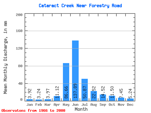
| Statistic | Jan | Feb | Mar | Apr | May | Jun | Jul | Aug | Sep | Oct | Nov | Dec | Annual |
|---|---|---|---|---|---|---|---|---|---|---|---|---|---|
| Mean | 3.92 | 3.27 | 3.97 | 11.11 | 86.65 | 137.88 | 50.86 | 22.52 | 14.52 | 11.50 | 7.45 | 5.24 | 355.96 |
| Standard Deviation | 1.42 | 0.91 | 1.11 | 5.39 | 37.95 | 68.35 | 28.47 | 15.57 | 9.54 | 5.69 | 3.17 | 2.17 | 125.98 |
| Min | 1.73 | 1.62 | 2.21 | 3.45 | 36.14 | 29.67 | 15.70 | 9.31 | 6.29 | 6.42 | 3.53 | 2.39 | 187.82 |
| Max | 7.49 | 4.85 | 7.13 | 21.24 | 183.91 | 299.80 | 136.97 | 88.41 | 51.06 | 28.88 | 15.46 | 11.52 | 572.15 |
| Coefficient of Variation | 0.36 | 0.28 | 0.28 | 0.48 | 0.44 | 0.50 | 0.56 | 0.69 | 0.66 | 0.49 | 0.42 | 0.41 | 0.35 |
 Return to R-Arctic Net Home Page